If you look at a map of the North Cascades mountains east of North Cascades National Park, it’s hard not to notice how many trails there are. Every drainage seems to have one. The connect every which way, forming all manner of possible routes for a weekend (or longer) excursion. I’ve explored the mapped trails between Ross Lake and the PCT extensively and was curious if similarly grand, though perhaps less manicured, experiences were available just a few ridge lines east. As other plans for the weekend had fallen through, I decided to eat the 5hr drive to Billy Goat Trailhead on Friday night.
Trip reports were sparse, though I found one mentioning that the Hidden Lakes trail was clear. Another recently reported a successful “Billy Goat Loop” (not the route described here) but didn’t describe trail conditions. I decided to go outbound towards Sheep Mountain up the Larch Creek Trail with the whimsical goal of playing tag with Canada by visiting Border Lake and, after a connection via Bunker Hill for which I couldn’t find a trip report, Monument 85. Hopefully, the relatively level Hidden Lakes Trail would carry my back to my car early enough to be home before work on Monday. This seemed like it would put most physically demanding parts of the route for which I also had the least information, as early in the trip as possible. If things got tough, it would be easy to turn around. What I worry most about on any new loop is not being able to close the loop and having to hike out over half the distance after having used over half the time. If you hike enough, eventually, you get to face your fears.
Purple (right) – Park Pass & Border Lake Trails – Mixed quality
Red – Boundary Trail – Very difficult to follow in places
Purple (left) – Monument Trail – Northern part doesn’t really exist. Connection over Pasayten re-routed.
Orange – Hidden Lakes Trail (not maintained) – Disappears south of mapped intersection with Boundary Trail
Yellow (left) -Hidden Lakes Trail (maintained) – Intended return route. Couldn’t get there from Boundary Trail
Green – a route extension for a 3rd border touch – Didn’t attempt.
Friday, July 17 – Prologue
I pulled in to the Billy Goat Trailhead just after dusk, having beaten the estimated arrival time by half an hour. Doing 15 over on the highway when the speed limit is 60 doesn’t change your arrival time that much. Doing 15 over on a dirt road where 15 is the safe driving speed changes your arrival time a lot. I did slow down after a minor loss of traction.
My plan had been to camp near the trailhead so that I could pack up in the morning and be sure I wasn’t missing anything. At the end of the parking lot where there might have been campsites, there was a large tent, which looked like an MSR Hubba Hubba, and it was a shaking. I figured that if there was some hubba hubba going on in the Hubba Hubba, the tent occupants wouldn’t notice if I slipped by looking for a campsite further down the way. It turns out that the tent’s single occupant was just arranging a bulky air mattress while his friend cooked dinner. I introduced myself and wound up chatting with Noah and Milo. Noah had hiked down the Hidden Lakes Trail and knew it to be clear as far as the Tatoosh Trail intersection as of three weeks prior. He also knew that there wouldn’t be any snow which was a relief as I’d brought microspikes and an ice axe because of some large white patches on the low-res satellite imagery I’d studied in preparation for this trip. In the end, there weren’t any more flat spots so after hanging out for a while, I returned to my car for the night.
Saturday, July 18
As I became conscious, laid out in the back of my station wagon, it was clear that while there were stars in the sky, the edge of the world was just beginning to get lighter. If I were at home, this would mean turning over and going back to sleep. For some reason, it’s just not easy to do that on a big hiking day. Maybe it’s because dawn and dusk are the best hours for hiking. Maybe it’s because air mattresses just aren’t as comfortable as spring mattresses with foam toppers. Either way, I fumbled around until I’d changed into hiking clothes, packed up my bag, and filled out a self-service trailhead permit. About a mile after starting up the hill, I realized I’d left my hiking poles at the car. Along with being useful hiking aids, I use them to set up my tarp at night and so the smart thing might have been to go back and get them. I hate hiking unintended miles and so I just kept on.
Billy Goat Pass and Three Fools Pass passed quickly as the sun rose slowly behind the eastern ridge line. Much of the area was an old burn and so the lack of direct sun was a blessing. The trail was well maintained and the rich ground cover made up for the spindly trees.
After Three Fools Pass, the trail descends to a stream where the Diamond Jack trail continues up valley. The Larch Creek Trail crosses the stream and after a quick jog west, heads north at an incline so shallow it feels flat. The East Fork Pasayten Trail splits off after you leave the burn area and are contouring along a densely treed slope. Looking up both Diamond Jack and East Fork Pasayten Trails, it’s clear that there Larch Creek Trail gets singled out for special treatment from trail crews.
About half way between Three Fools Pass and Larch Pass, I slipped on a rock and fell crossing a small stream, but in such a way that I didn’t get wet. It was one of those falls where you don’t get much of a chance to save yourself and I was fortunate to be wearing a backpack. On of my fingers tore slightly under the nail which, combined with hands swollen from not having anything to do (usually not a problem with poles), meant my hands were the source of most of my displeasure. On hiking trips, it’s usually feet and shoulders that hurt. I guess variety is the spice of life.
Larch Pass did have larches. It was about 11:10am and I took my first sit-down break there since starting at about 4:40am. I was making little voice recordings thinking I might post them and save myself the time writing a trip report. Usually they captured shallow, momentary thoughts. Just as I would finish recording, I’d think of something else I wish I’d recorded. For all their lack of narrative and detail, they capture some interesting impressions. At Larch Pass, I said that, “the mountains are soft and the trail is soft.” Thus far, the trail had been well maintained and not tightly compressed or rocky. The mountains tended to be round, like hills, not jagged and rocky like the classic pictures of the North Cascades. One side would have fallen off and form the head of a drainage but the other looked like a walk-up. The mountains were also generally covered in grass or dirt, perhaps with some amount of stones mixed in, but not edifices of rock. While I don’t know the geologic processes made these mountains, perhaps this softer shape is because I was on the east of the range and whatever tectonic, volcanic, or glacial forces created the North Cascades aren’t as strong here.
The trail just after Larch Pass descended to a signed turn-off to McCall Basin. There was only the slightest hint of a trail at the turn-off, something that would soon become a theme of this trip. However, the meadow spreading down the basin and up to the turn-off for Corral Lake, was incredible. While I had intended to walk at whatever pace came to me and found that pace was much slower until Peeve Pass for all the pictures I took.
Sand Ridge, which starts near the Corral Lake turn-off appears to have a trail up it which wasn’t on my map. The Larch Creek Trail runs through the bowl under the ridge and up to a point near the end of the ridge before dropping to Peeve Pass. If I’d been in a more exploratory mindset, I might have tried to see if it went since it would have provided sweeping views of the area. My voice recordings for the area use “awe” and “a whole lot of pretty” to describe it. There was a trail coming down off the ridge at the other end, so I expect that it goes.
Peeve Pass is one of those odd passes which you descend to instead of climb to. It’s been burned recently and while plants are beginning to come back, the ash on the surface makes digging a cat hole easy. I turned left for a short jaunt on the Boundary Trail to the Park Pass Trail. It’s a good thing that there’s a sign for the Park Pass Trail because, the trail itself isn’t really visible.
I thought that this might stop my first attempt to tag Canada just short of the border. Fortunately, after walking a dozen or so yards, it’s pretty easy to see the cut of a trail in the earth where it crosses a streamlet. Usually, trails are distinct in color from the surrounding dirt but the fire made everything a uniform grey. While plants are a little less likely to grow on the trail, there were plenty of them coming up through the trail floor. When they grow up, they’ll obscure the subtle cut of the trail in the side of the hill and make it impossible to follow. While it’s easy enough to follow for now, I hope a trail crew gets there in the next few years before we lose the Park Pass Trail completely.
While the Park Pass Trail is still in good condition north of the fire scar, I was looking for the turn-off to the Border Lake Trail and if I hadn’t had a GPS, I wouldn’t have realized that I’d walked past it. There is a turn-off in the area but it leads a short distance to what must have been a camp full of discarded metal cans before the fire swept through. The terrain here is open and gentle and I could see what was probably a trail (and not just where water carved a trail-looking rut) and so walked to it. This turned out to be the Border Lake Trail which brought me to the border, then disappeared.
At this point, I was split about whether I really wanted to go to Border Lake. I’d tagged the border which was my primary objective and didn’t particularly care to climb a hill. Still, I’d gotten this far and wasn’t likely to do that again just to visit Border Lake so I took a bearing with the GPS and followed it to a low point on the ridge. A trail materialized just below the top. Just over the top, a lake materialized. The combination of gentle, open travel on one side and sudden drop-off on the other is quite dramatic, even if the features are slightly rounded.
I ate lunch on the ridge above Border Lake. I’d brought hard boiled eggs and avocado and didn’t want to let these perishable, crushable, delicious foodstuffs stay in my backpack any longer than necessary. Unfortunately, I’d also been snacking heavily and so was significantly stuffed on the trip back to the Border Trail.
I hadn’t committed to a specific itinerary, knowing that it might be hard to predict trail quality and conditions. Feeling lethargic after a big lunch, I didn’t want to be ambitious, and decided to work my way at a comfortable pace as far as I felt like going.
The Border Trail clearly had receives less maintenance than the Larch Creek Trail but was easy enough to follow through meadows and burn areas. In some places it was very well maintained, in other places it was a relatively indistinct. There were several unmarked side trails which I mistook as the Quartz Lake Trail. Clearly, this area has more to offer than an official map would show.
The gem of the afternoon was a walk along a level section of trail high on the south side of Quartz Mountain. The views swept from west to east. The travel was through alpine meadow and few trees interfered with the view. The camera on my phone can’t zoom in on the rest of the Cascades which guarded the horizon with variations in color and form. The two words most immediately in my mind were “divine” and “sublime”.
This slice of heaven ended abruptly, in classic Boundary Trail fashion, at an intersection where the trail forked. One forked looked grey and little used. The tan trail in good condition bent slightly uphill and disappeared within 10 feet at a cairn. Which to follow? The GPS said follow the cairns. It felt schizophrenic.
As the slope began to roll over, the trail picked up again and carried quickly down to stream where where the climb to Bunker Hill started. The fire damage early in the climb was significant. There were also a significant number of cut logs. The trail would have been very difficult to follow but for a significant presence of cairns which had been placed liberally and creatively to mark the way. Before a trail crew had cleared those logs, it might have been impossible to follow the trail as opposed to making your own way. Perhaps the significant quantity of blowdowns had been left for so long that the trail didn’t receive enough traffic to beat the plants back.
I’d been moving slowly and breathing hard due to a heavy stomach from a late lunch. Attaining the top of the ridge which climbed slowly to Bunker Hill took much more effort than the map would have implied. The dramatic views last seen on Quartz Mountain returned along with a clear trail and I was relieved.
It was now a little before 7pm and I’d considered the top of Bunker Hill as a potential place to stop for the night. The views wouldn’t hurt and there were several campsites sheltered in small stands of trees. Four cement blocks with what looked like metal axles were on the east side of the summit which makes me wonder about the history of the area. Perhaps they were footings for a fire watch?
Unfortunately, I hadn’t been thinking ahead and was down to a little less than a half liter of water which would not have been enough for dinner, much less the night. There were two hours of daylight and a little less than 6 miles down to the Pasayten River. While good campsites may appear in the most unlikely places, the map showed only one area which appeared to flatten out. The route seemed to mostly follow the nose of a ridge and so it seemed unlikely to have water until the Pasayten. Six downhill miles in two hours with the motivation of waning daylight would be clearly doable on a normal trail but the Boundary Trail seemed to appear and disappear as it pleased. Also, the front of my left-leg just above the ankle had be aching when stepping downhill. If the sun went down, following it might be very difficult to figure out where to go. Camping on the top of Bunker Hill would have been and been a pleasant experience but with so much daylight, it seemed better to try to do something about the water situation. The trail ran above what the map showed as a seasonal stream and so perhaps there’d be water there. If I got to the flat area without finding water, I decided that I would camp and not risk losing my way in the dark. Decision made, I stood up with the grace of a rusty robot and continued on.
There’s are two routes down from Bunker Hill. On my map, there’s a climbers route marked in small dots on which comes up from the south. It follows a long, broad, soft ridge rising up from the valley which I’d seen on on my approach. It looked enticing, though maps show things getting more complicated below the treeline and that’s what I was hoping to avoid. My intended route followed a different ridge west along the official Boundary Trail and is marked in a bold line. In a classic case of the map not matching the ground, the climbers route was a deep, double rutted line and the main route was invisible where it turned off, marked only by a cairn.
At the point where the main trail turns invisibly off the secondary route, the ridge to the east began forming and on it were several patches of snow. Above the patches of snow were sheltered campsites. I’d brought a stove on this trip and so had everything I wanted: water, a sheltered camp, and a beautiful view. While there was more daylight, I’d logged 14+ hours on my feet and my left leg was hurting in in a “repetitive stress injury” way not a “tired and sore” kind of way. More miles might make tomorrow easier but they weren’t going to improve the situation now so I put down my pack. Camp routine followed: I melted water, cleaned my feet, ate dinner, tied my tarp up between a few trees, enjoyed the sunset, then crawled under my tarp and neslted into my bug bivvy and under my quilt.
Sunday, July 19
I slept well and woke easily at the first hint of light. The morning was dry and warm. This made packing up so much easier than when dew or frost makes everything damp and sloppy while your fingers hurt when you need them to be dexterous. By 4:30am I was following cairns across a broad slope by headlamp. At one point I felt the hoof-falls of a herd of deer through the soil of the ridge as they galloped away, just smudges in the dark at the edge of a clearing. As the edge of the sky turned the color of egg yolk, I picked up a trail again.
The trail ran downhill steeply at first, then shallowly across the drainage under the ridge where I’d camped. There was a stream here and an established campsite. It was comforting knowing that I’ve have had a good situation the night before, even if I hadn’t made the decision to camp where I did.
After that, the trail began degrading. There was a critical left turn onto the ridge which sloped to the Pasayten which I almost missed. I did miss a turn which happened just where a large log had fallen, making it look as though the trail continued underneath. For a while I wandered in an open forest of blowdowns and snags, generally following my GPS until suddenly a section of trail reappeared.
Eventually, signs of the trail became faint again and at a critical moment, I was unable to find another cairn in my direction of travel. On the GPS, the trail took a hard left down a narrow, steep gulley then began to traverse a steep hillside. I’d seen a few places where there might have been trails diving over the side and I could see what might have been scuffs in the dirt from people (or deer). Nothing was clear but the GPS really did seem to indicate that you turned off the gently sloping ridge here, only to meet back up with it later. I’d have been better served by just following the ridge.
The gulley was very steep but mostly grass covered which made for more solid footing. I slipped twice where bare dirt slid under foot from the angle. I naturally lean back away from perceived danger which reduces traction and makes me more likely to slip. Trees were frequent companions which I used to steady myself. I couldn’t quite stay on the line the GPS indicated and decided to find the easiest way and meet back up with it later. As the the trail on the GPS’s map began to travel across the slop and not just down it, I was very glad to have brought stiff shoes intended for kicking steps in snow as they held better for the steep traverse.
Eventually I came to look across a dip where the trail was supposed to cross and contour below a small knob. I saw what might have been a hint of the scar of a trail on the knob but it didn’t seem to come from anywhere or go to anything. I have plenty of experience chasing lines in the dirt which turn out not to be trails and so ignored it. The GPS showed me as being below the trail and so I planned to walk along a bench of sorts and wait for the trail to come down to me. Some deadfall pushed me up a dozen feet or so onto the knob and… I saw a cut log. Looking along the path it indicated, I could see trail. This was a most welcome surprise. Measuring on a map now, I looks like I was off trail for a little over half a mile.
The trail from here was easy to follow. One of the advantages of it cutting across a slope is that you know it probably won’t go to the right or left very far. There were some blowdowns and eventually the trail degraded under wetter conditions as it switch backed down to a water crossing. I was actually quite happy that the water crossing wasn’t overgrown or excessively muddy. The trail just climbed out and contoured out of the drainage.
This brought me to an unexpected, unwelcome, and foreboding sign. It was a three-way intersection between the Hidden Lakes Trail (Not Maintained) and Boundary Trail Re-Route, but was about a mile earlier than expected, apparently because the Boundary Trail had been re-routed. I was expecting to cross the Pasayten River near the site of the Pasayten Cabin and then turn north on the Monument Trail to tag the Canadian border again. Would this re-route connect? What did it mean that the Hidden Lakes Trail was not maintained, especially given the poor state of the Boundary Trail which apparently was maintained. The Hidden Lakes Trail was supposed to be my route home.
What I probably should have done at this point, was to try and take the Hidden Lakes Trail back to my car. If it didn’t go, then I’d learn that as soon as possible and so would have as much time go retrace my steps the long way I’d already come. I considered the option but, the sun hadn’t yet crested the mountains and the Hidden Lakes Trail seemed like it should run a pretty clear course along the Pasayten River. I’d worked my way past so many blowdowns that it didn’t seem like it could be much worse. Maybe the Not Maintained was just a warning because it was a more popular trail and the rangers were trying to scare less experienced hikers. I turned onto the Boundary Trail Re-Route and hoped for the based.
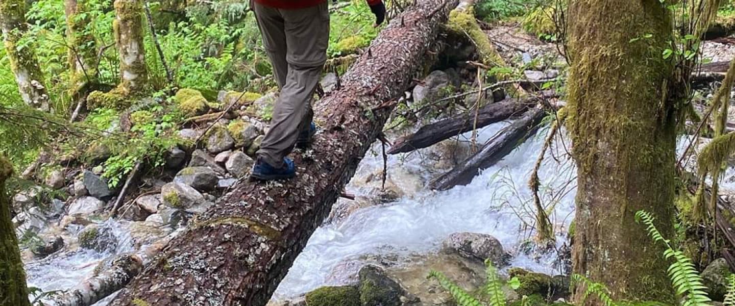
The Boundary Trail Re-Route brought me quickly to the Pasayten which might have been difficult to cross given that we’d had a cold spring and the snowpack was still melting. However, the ford was well chosen and after grabbing a pair of sticks to substitute for the hiking poles I’d forgotten in my car, I crossed and found that the water went only just above my knees and didn’t press hard.
The trail from here wound its way to the edge of a bank of earth and climbed out. I guess this bank represents how wide the Pasayten gets at flood stage or some previous course it had taken. The trail was clear and turned south on top of the bank. I took that left turn and walked for several minutes expecting to find an intersection with the Monument Trail to take me the 1.5 or so miles to the border. Not finding an intersection, I checked the GPS and discovered that I was on the Monument Trail. Retracing my steps to the point where I’d the Boundary Trail Re-Route had climbed the bank, I was stymied that there was no indication of a northbound trail.
I wanted that to tag the border and expecting that a trail might pick up if I persevered just a little bit, I picked the most promising looking line through the grass and followed it, pushing my way through closely packed trees. As I was about to give up, I discovered an old, degrading trail! I followed this north feeling very satisfied with myself. Unfortunately, it too quickly degraded and I found myself making forward progress by walking on blowdowns and taking hints from cut logs which indicated old trial maintenance. Eventually, I looked around and saw nothing but fields of blowdowns. Previously, the hints of a trail had followed an embankment but as that degraded, there was no guidance as to where to go other than to follow a bearing due north. I was here for a hike, not a bushwhack and given the concerns I had about the Hidden Lakes Trail, I didn’t want to burn precious time. I turned around and worked my way back, getting lost in the process and having to use my GPS to get back on course.
Back on the Boundary Trail Re-route, I cruised south for a mile or so to the point where a trail on both my map and GPS crossed the Pasayten. The Boundary Trail in this area had been hacked through a forest of blowdowns and while this made it a very clear trail to follow, it also made it very clear where there was not a a turn-off. There was no side-trail, connector, spur, or other indication of trail where the GPS said there would be a way over to the Pasayten Cabin (apparently now burned down) and then across the river to the Hidden Lakes Trail. I jumped up on a log at the top of another embankment, looked across the river valley, and saw only fields of blowdowns. Stymied for a second time, I walked quickly back, crossed the Pasayten at the re-route and took the Hidden Lakes Trail, making a voice note that I really needed this to go otherwise it would be a very long day.
The Hidden Lakes Trail, while clearly not maintained, was easy to follow, certainly compared with the descent from Bunker Hill. There were some blowdowns and the trail was narrow here, overgrown there, or eroding off a slope in another place, but there was never a question of where it went. Then, just south of where the GPS indicated an intersection with the trail which crossed the Pasayten, the one I’d failed to find on the west side of the Pasayten, the Hidden Lakes Trail descended to the river level and disappeared into grass, blowdowns, and moderate trees. I pushed forward several dozen yards but nothing materialized. I climbed back up to where it had contoured above the river valley and couldn’t see anything which looked like a trail.
From here it was about 5.5 mi to where I had assurances that the Hidden Lakes Trail had been cleared. Bushwhacking in a river valley has been as slow as 0.5mi/hr for me. It was now after 9am and I didn’t want to risk 11hrs of hard travel. The brutal calculus was now that it was much more of a sure thing to return the approximately 30 miles by which I’d come. This was helped by the fact that I thought there were only 5,000 or 6,000 ft of elevation gain which felt like a big effort but not unreasonable. Looking now on Caltopo it appears to be more like 10,000ft of gain which is a very big day no matter how you cut it. While frustrating and anxiety inducing, I’d realized this was a possibility and so the decision was quick to make. I turned around felt a fresh purpose in my stride. Then, just after rejoining the Boundary Trail, I saw a well built, weathered man with an unusual backpack (clearly not from a common backpack vendor), coming towards me. It was around 10:20am and I hadn’t seen a sign of humanity since passing some tents the previous morning. On the Boundary Trail, I’d only been able to discern a single other pair of footprints in the mud.
As we approached each other, I asked the man if he had come in by the Hidden Lakes Trail and happened to be on his way out, hoping desperately that I might follow him along some easy way which I had failed to discern. In describing his route, he explained that he’d come in on the Boundary Trail and not known about the re-route. When he got the the non-existent turn-off, he’d used his GPS (something he uses rarely), to bushwhack across the boggy fields of blowdowns to the old bridge. The bridge is out and he showed me a picture of the footings. He mentioned finding a three-way intersection and some flagging which hinted that the Hidden Lakes Trail might be more real than I’d determined. The going had been very difficult and he’d gotten a pair of gloves from a horse packer at his destination to protect his hands on the way back.
As the conversation continued, it turned out that we’d both hiked the PCT. He said his trail name was Bink, which I recognized but couldn’t place and I told him that I’d been DQ. He mentioned having hiked the PCT several times and having had the speed record before Heather Anderson. I was floored. I was trying to figure out who’d had that record between Scott Williamson and Heather Anderson, and a dumbfound look must have given me away. “Scott Williamson” he said. Oh, I thought. “I’m Isaac” I said and tried not to look too star struck. I’d heard Scott’s name a number of times in the long trail community and read about him in The Pursuit of Endurance. I remembered him being portrayed as a private person, so tried to make some conversational opening whereby it would be appropriate for him to leave if he wanted, but he stayed, smiling a wide smile and throwing his head back at points of common understanding. I asked about how the PCT had changed over the years. We wound up trading beta on trails near the Canyon Creek Trailhead just east of Olympic National Park. His memory was fantastic and he pulled out maps to show me notes he’d made, sometimes as long as 10 years before.
As the conversation wound down, he double-checked that my plan was to hike out a 30 mile day via the Boundary Trail. I explained that at this point, I needed a sure thing and wasn’t willing to risk that I might have to do 5.5 miles of the bushwhacking through terrain similar to what he’d had to do when he crossed the Pasayten. We commiserated over the state of the Boundary Trail, and he remembered that the Park Pass Trail hadn’t been visible from the turn-off. It was validating when someone who I respected for their athletic ability and grit thought I was a little crazy too. He ended by asking if I had enough food and wishing me well on my way trip back to the car.
Shortly after parting ways, I crossed the last stream for several miles until the drainage below the summit of Bunker Hill. I checked that I had sufficient water by pressing up on my water bottle in its pocket and feeling how heavy it was. It felt full so I continued without drawing water. When I pulled it out for a first drink, it had about four mouthfuls. The mindgames and bodily awareness which happen when you’re worried about water are fascinating. I monitored every bead of sweat, how quickly my clothes dried, how cool the sweat made me feel, how thirsty I felt, and on and on. This was eventually mixed with finding my way up the trail which had eluded me on the way down. Following it in full sunlight helped, though several times I had to stop, look around, and retrace a few steps before determining which way to go. It was in this section where my my climbing muscles ran out of free vert (“free vert” is related to an odd effect where my legs hit a point where they rapidly go from feeling strong to weak; once weak they never return to strong for the rest of the day as though my “free vertical gain” had been spent I’d have to do real work for any remaining uphill travel). While the burned out snags did little to provide shade, they allowed me to see the top of Bunker Hill from a distance and monitor my progress with precision.
When I finally came to a little stream in the bowl under the summit, it felt like salvation. I rested heavily and drank a lot of water, initially in small sips. Having been out of water had made me lose objectivity about my condition and it was a little concerning to have a second measure of exhaustion tell me that I’d been quite depleted. I ate a light lunch, remembering how hard it had been after an oversized lunch they day before. In addition to stopping for a conversation, I had not made quick progress uphill. My left leg was now bugging me, even on the uphills. It was about 1:40pm when I left and I made it a goal to be back at Peeve Pass and the easy travel of the Larch Creek Trail by 5pm, something which seemed like an easy goal under normal conditions and I secretly hoped to make it by 4pm.
The trip back over Bunker Hill and Quartz Mountain were beautiful but the need for constant progress was in the back of my mind and I tried to take fewer pictures. Still, the flowers were out and I noticed some things I hadn’t before. On the beautiful traverse behind Quartz Mountain I sat down and had something of a pity party while I released my left leg from the ache it felt on every step. If I hadn’t forgotten poles, I could have managed my leg better. However, when hikes stop being fun for me, it’s usually something external to the route or conditions, something about expectations. In this case, as was the case on the Hayduke before I let myself skip a section, adversity had extended the trip and the need to be back to my employer at an appointed time weighed heavily on me. My calculated finish time for the day swung between 11pm and 4am. Then there would be a 5hr drive home which would have be salted with just enough naps to safely operate a vehicle. If this had been an open-ended thru-hike, I might have just stopped for the night to prevent further injury and revel longer in the natural beauty. I checked the time. In two minutes it would be 4pm, the pre-determined end-time of my rest stop. Pity parties are useful when you need to accept your fate and the rest noticeably improved the ache in my left leg but progress was the medicine I needed and those two minutes meant I could get a head start.
I reached Peeve Pass ahead of time at 4:50pm (goal of 5pm) but still feeling slow because I was so close to a low-ball goal. Turning on to the well kept Larch Creek trail was an emotional relief because I didn’t feel subject to the vagaries of trail condition. There were five climbs between me and my car. The new goal was to finish the first three before sunset. This wound up being easy since my leg stopped hurting on uphills and the first three climbs were relatively close. Since I wasn’t moving fast and was at peace with my fate, I got to enjoy the same country which brought the words, “awe” and “whole lot of pretty” to mind on the way out, but was now improved by the light of golden hour.
The descent southbound from Larch Pass was long and despite being gently graded, aggravating to my left leg which I was now processing as pain, not just soreness or ache. I tried to run at a shuffling pace as that keeps my foot in a more consistently flexed position instead of flexing and unflexing as with a walking stride. This worked for a bit then became slower than walking, so I alternated between walking to recover energy until I wanted to shuffle along again to reduce ache.
My mind was wrapped up in this back and forth and projecting finish times when I heard, “Isaac” shouted after me. I shuffle-ran back a few dozen yards and found Noah and Milo, the friends I’d met on the night before starting this fiasco. Since I was going to have a late finish anyways, really wanted a break, and knew that conversation would help my mental state, I sat with them for 10 or 20 minutes and traded stories from our weekend. It sounded like they’d gone up the trail I’d seen ascending Sand Ridge and had gotten the same sweeping views I’d seen when traversing along Quartz Mountain. They didn’t keep me long but I moved on with spirits much improved.
My immediate goals were now to get to the turn-off for Dollar Watch Pass before sundown and to find a place to poop which would make the chore as quick and easy as possible. I succeeded on both counts.
Night came at the stream from which the trail climbs to Three Fools Pass. I’d stopped to draw water, to refill the snack pockets on my pack, and to put on my headlamp. Without being able to see much outside the headlamp, I found myself taking the climb slow since I couldn’t gauge how much distance was left. My leg didn’t hurt and my mind entertained flights of fancy. It was pleasant and peaceful and I was working through the last 6.3 miles.
The final descent from Billy Goat Pass was very trying. Despite being 1.8 miles and downhill, I stopped twice to sit down. I was having to brace for the pain on each left footfall and was trying not to slip into guarding behavior or bad form. Additionally, the soles of my feet were both aching from pressure and the lacerating feeling of the fine fibers of my socks being mashed into them like a net made of cheese wire. I think this was due to having picked control-oriented shoes with thin, stiff soles and almost no padding. They would have been a good choice if there’d been snow but now they left me wanting the shoes which I’ve come to think of as trail slippers.
I reached my car at 12:37am and was oddly controlled, arranging my gear for the drive while standing instead of immediately collapsing into a seat. While relieved that the worst was now over, this seemed oddly like an aid station in a long race. The next leg would be the drive home and after that a day of work. Somewhere in there, I’d need to sleep. A key detail was to put my socks in a plastic bag where they couldn’t stink up the car. Unfortunately shoes were too large to fit and my feet would have felt horrible in plastic so I let them dry for a time before coming to terms with the level of stench I’d be living in until I got home. As I pulled out of the trailhead, the balls of my feet hurt enough from using the brake that I let the dirt road carry me away at the fastest speed I could rationalize as safe. The long anticipated caffienated soda was ineffective and just a few miles later, my head began to swim with sleep. I pulled over, leaned back my seat, laid my quilt over me, and passed out.
July 20, 2020 – Epilogue
It took three naps to get home. The longest was when I pulled off at the Canyon Creek Trailhead after having watched the sun rise over the North Cascades.
When I reached cell phone service, my phone exploded with the contents of the busy weekend I’d missed and I tried to reply to the time sensitive ones and let my emergency contacts know I was safe. Fortunately, I’d had the foresight to tell the not to expect to me until Monday morning.
I pulled into my parking spot around 9:40am and managed to be showered and working from home by 10am. Late, but not usually so in the software industry.
It was about two days before I was walking normally and had to back out of a trip to the Enchantments the following weekend to let my leg rest. Since running doesn’t hurt it as much, I ran 12 miles to officially finish the GVRAT on the same day as my mother. This probably set the recovery back but some things in life are important.
Finally, a big thanks to Noah, Milo, and Scott for their conversations on this misadventure. I didn’t give any of you this blog’s URL, but if any of you happen to find this please know that your brief companionship was a significant boon to my spirits in a rough moment. I hope to see you out there again some time.
