
Saturday
What I’m calling the Grey Wolf – Cameron loop started at the Deer Park trailhead around 10am. The late start was due to the usually obligatory visit to the Port Angeles Wilderness Information Center for the purpose of getting permits, passes, and parking (the 3Ps of Olympic National Park) arranged. This time I was informed that trips originating from the Deer Park trailhead could be arranged by phone and mail.

The trail descends a steep hillside and dumps you into a river valley where the’s a campsite with a shelter. This struck me as a great place to take people for a first backpacking trip: secluded feel but easy access and well signed, existing shelter in case of gear issues or rain, campfire ring to play with fire, lots of interesting streams, and a tough climb out so they’d have something to brag about the next day.

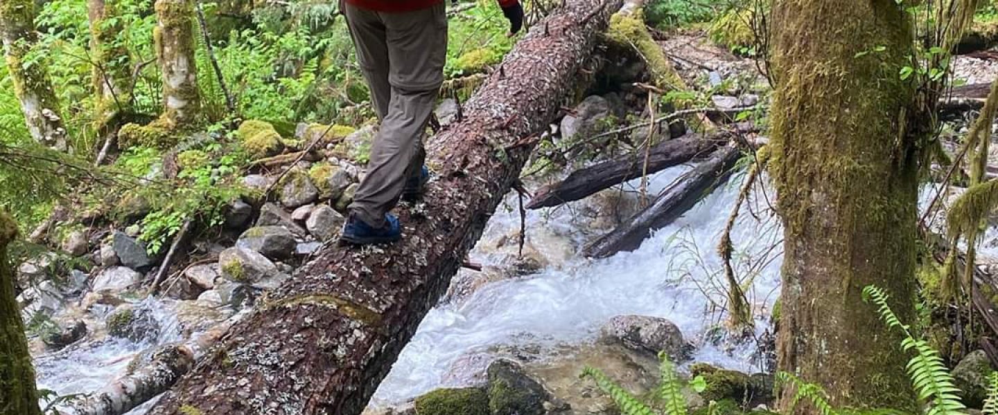
Immediately thereafter is a bridge across Grand creek. Despite the large number of signs, before the crossing, the trail towards Gray Wolf River became indistinct and I spent some trying to figure out how to get across, instead of along, Cameron Creek. It’s a little more confusing in person than when looking at the map since there are multiple streams which merge in the area and I wanted to be sure I was at the correct one.

The area is covered in moss and old, fallen trees. This continued as I turned up the Grey Wolf Trail.
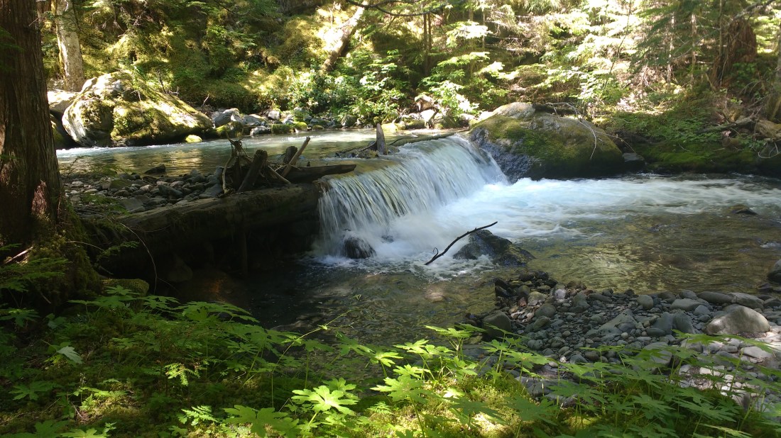
The Grey Wolf Trail climbs gradually, eventually escaping the moss and enclosing trees. My first and much needed break was at what was clearly a well maintained campsite adjacent to the river though the Olympic National Park trip planner didn’t show it. I would encounter several of these on this trip. They create a feeling of depth, that there’s more history to this place than you can learn by looking at a map.

The final climb up to Gray Wolf pass saw me taking a lot of stops to enjoy the view (aka catch my breath). The stunted trees and low scrubby ground cover are actually some of my favorite flora because they decorate instead of obfuscate the underlying terrain.
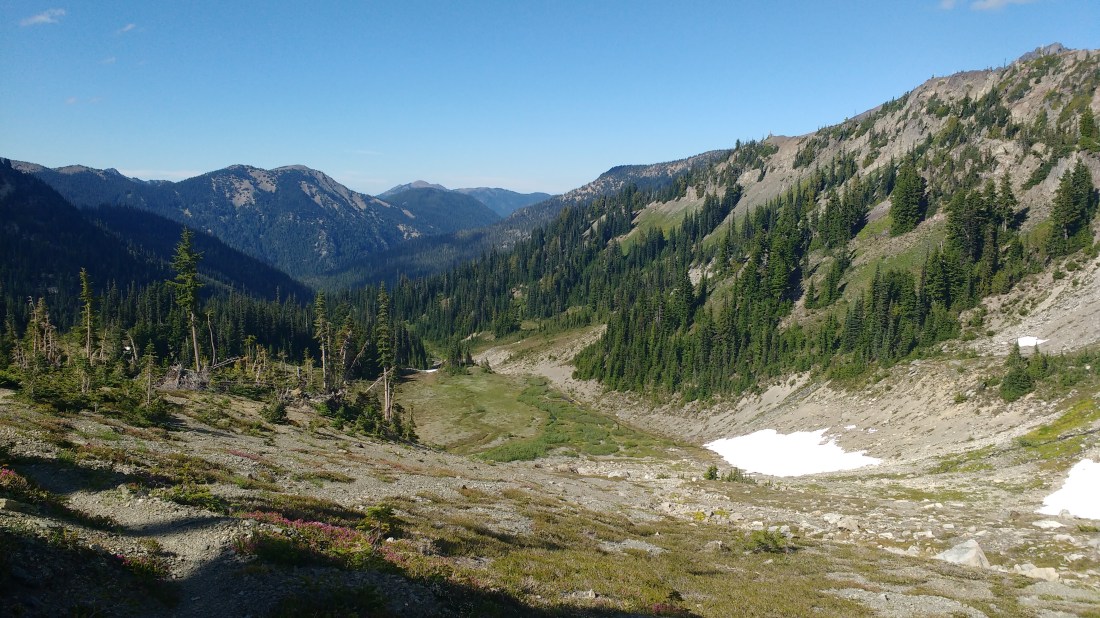
The pass itself was par-for-the-course beautiful. I hadn’t seen anyone since turning up the Grey Wolf Trail and the isolation produced wonderful sense of engagement with the surrounding and valleys.

The trail continued down the other side of the pass into a valley running perpendicular. I’d passed through the same area on my big pre-PCT training hike in 2015. The tall grasses and leafy, flowery plants press in around you and sometimes overwhelm the trail a little. It’s probably a pleasant section to meander and revel, but compared to the expansive high of being in the open spaces near the top the pass I’d just crossed, it felt a little constraining.

Per itinerary, I camped at Dose Meadows where I had on my pre-PCT trip. It was about 7pm and I was considering getting a head start on tomorrow’s climb since from the map it looked steep I figured there was at least an hour of daylight. Instead, I contented myself with scouting where the trail to Lost Pass forked off since I hadn’t seen it on the way in to camp and the map marked it as a “primitive trail”. Primitive trails in Olympic National Park had never failed to produce some engaging and stressful adventure.
Sunday
The hike up to Lost Pass had appeared quite steep as I’d tried to trace it from below. Despite being worried about the trail quality, it was well cut and I soon found myself at the top. The traverse to Cameron pass was relatively level and well cut. I love high traverses where you can look out and down and see far away things, not just up and see trees. It was short and so pleasant that I didn’t even think to take a picture.
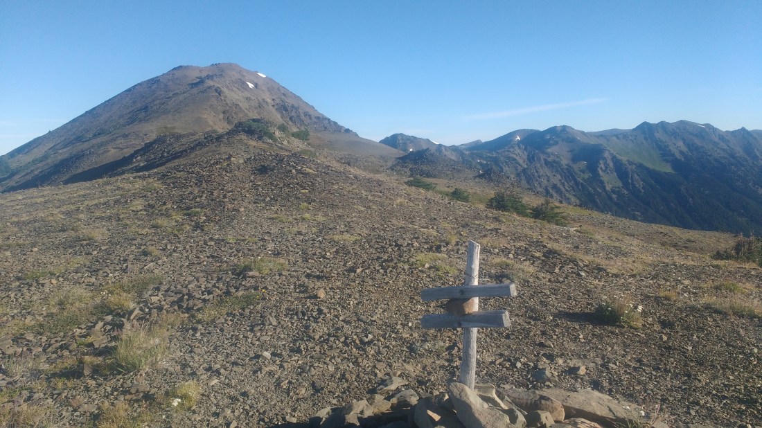
At Cameron pass, the middle of the trail sign at the pass had fallen out and rocks had been put in a spacers to replace it. Seems like it should trade signs with Lost Pass.

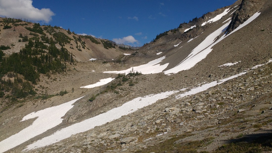
To the north from Cameron Pass runs a soft ridge of mounds which, from the topo map, looks like they almost connect to Grand Pass which in on an alternate route I was considering. The elevations lines were so mellow and far apart that it was enticing to try a little off-trailing, especially since I’ve realized how much I use the presence of a trail as a safety blanket instead of constantly being aware of my surroundings. As the ridge line turns north-east, however, the elevation lines come closer together and so I decided to resist the temptation to take what looked like a faint use trail off to the north. Off-trailing would just have to wait, though only for another hour or two.
The trail down from Cameron pass was clear but steep and the gravel was loose. It’s clearly not well maintained but is sufficiently traveled that with this little vegetation, no maintenance is needed.

After descending the gravel and reconnecting a good old solid dirt trail which passed a campsite, I found myself in a small, soggy meadow which the trail clearly entered but did not appear to exit. I walked back to the campsite I’d just passed thinking I might have taken a side trail out of it but other branches seemed to peter out even faster. It was time to see about those cross-country skills after all.
Google Maps which told me that there was a lake or pond directly north along the trail. After that, the little blue dot (me) turned grey (no GPS) and didn’t update as I moved. After rebooting the phone, the trail which had shown previously didn’t show. As the employee of a corporate rival to Google, this felt like a particularly low blow.
Fortunately, I had a map and compass. Or rather, map because I’d forgotten or left it at home because I’ve never practiced triangulation or any other useful compass skill besides orienting a map. Fortunately, the map showed the same body of water I’d seen on my phone and so I roughly followed my compass in that direction. Unfortunately the body of water wasn’t there.

My confusion from the missing body of water stemmed from the fact that in an area which might generally be characterized as a large, gently sloped “bowl” (in the skier, not soup, sense of the term) below a pass but well above the valley along whose bottom the trail eventually ran. There isn’t much room for a lake to hide. I assumed that a body of water large enough to put on the map wouldn’t be seasonal. My searching uncovered a depression which a pond might have been but it was covered with grass not bog or dry lake bed. Also, the depression didn’t have an outlet stream on the tip facing the valley, it had a large embankment on that side.
The advantage of my position was that I couldn’t really get lost. I was hemmed in on all sides by mountains. One way or another, I just needed to get to the bottom of the valley and cross the stream. If I just kept walking away from the stream, I’d have to cross the trail. Trails don’t just disappear for no reason and then reappear elsewhere (OK, they do, but I wasn’t thinking that at the time despite being in a situation caused by exactly that). So I set out on a meandering course following whatever seemed like the easiest way to lose elevation. I also didn’t think to keep taking pictures so you’ll just have to read the narrative.
The problem with just trying to find the easiest way down is that I’d frequently run into little cliffs. They wouldn’t drop far but were definitely too steep to for me to descend. They’re also not really visible on a topo map. I guess they kinda sneak in between the elevation lines or get lost in some sort of averaging. Eventually, I wound up climbing down the dry edge of a small water fall maybe three times my height because the exposed rock was easier to grip than dirt.
This little cascade of water of water met up with a stream which would probably have been less than knee deep but was wide enough that when I wanted to cross, I found several dry stones peaking out of the flow to form a rock hop. This stream I followed figuring it was a tributary to Cameron Creek. I crossed it again as the bank I was on became a steep cut and continued through a flat area with light underbrush until I ran into a real drop off.
This new waterfall leapt off the side and down far enough trigger my concern about getting too close to the edge. The creek below didn’t really have banks, it had tall, steep, eroded sides hundreds of feet tall. I imagine, when the banks just collapse like an iceberg calving. Striking out eastward, I followed the forested rim which the vertical, light, red-brown dirt rushed up to meet. No way down that either.
My search for a way down probably didn’t take very long in either time or space but as I lack experience with this kind of situation, and being alone, it felt like a big deal. Strangely, there’s a kind of time pressure knowing that you’re expected to be back at your car before the rangers notice and call you in missing. Or my boss starts wondering on Monday why he hasn’t seen me. I have no particular concern for myself as the food in my pack will last an extra day and there has to be some way down since the small patches of snow I’d crossed showed others’ footprints. Worry about not meeting expectations makes you a great student, an average employee, and keeps your mother’s nerves calm (I was a pretty well behaved kid) but it does not help you find a way down. This is what I’m thinking when I find the trail again, a few steps from being under my own feet.
Within those few steps it is clear that this trail is not the the trail but a deer trail. I have a habit of mistaking the deer trails as human trails, particularly lost while following lines marked as “primitive trails” in the Olympic National Park Wilderness Trip Planner. This time, however, I decide to follow the deer trail since deer, not being able to teleport, must have gotten up here the same way that I must get down – one step at a time. This logic is exhilarating.
Deer, however, have more feet than humans and those feet have small hooves which jab into dirt kinda like small, dull crampons. At least that’s what I imagine as I lay my body (disconcertingly upright given that my stomach is in contact with the dirt) on the forested slope while I grasp at little roots and try not to move more than one appendage at a time. The there are enough trees that if one of the shrubs gave way, I’d probably hit something before sliding too far. However, they’re just far enough apart that I think I’d work up enough speed while falling between then that I couldn’t hang on. In reality, it was probably less than a dozen yards before the slope eased enough that I was able to stand with hips perpendicular to the slope and step forward placing each foot carefully.
Things continued to flatten out and eventually became quite easy despite it being my first time hiking seriously off trail. I would lose the deer track from time to time the following a path of least resistance would usually link me back up to it. When the slope was low enough, I started zig-zagging down pretend switchbacks towards the valley bottom.
The creek at the bottom of the valley was choked on both sides with bushes which were the were the first bushes I’d had to whack on my inaugural bushwhack. I entered the creek barefoot with my shoes around my neck and walked upstream a few yards in knee deep water to a gap in the defensive breastwork of bushes on the far side. After using the opportunity to give my now clean feet little care, I crawled up a steep embankment and before I had stood up, could see the trail. The real Cameron Creek Trail this time. Que a flood of relief.
From there back to the campsite with the shelter was largely unremarkable aside from seeing the remnants of an abandoned cabin and some temptation to explore the side trail up to Grant Pass. There and been enough adventure for one day and so I knocked down the miles back to the car as quickly as possible. I was in such a rush that I didn’t take on water before ascending the steep last four-ish miles up to the trailhead wound up incredibly thirsty.
The camp near Deer Park doesn’t have a spigot. However, while searching for one, I encountered a friendly volunteer staffing the ranger station and we got to chatting about the history of the area. It turns out that heading north from Cameron pass as I’d been considering wouldn’t necessarily have gotten me around to Grant Pass but to another lake where there’s an old trapper’s cabin. He told me about a few other secret destinations and gave me a bottle of water when I tried to cut the conversation short to keep looking for one. Finally, in a satisfying coda to the days events, he confirmed that there is no lake near Cameron pass.
