I was signed up for the Sawtooth Ridge 50 miler over July 4th weekend. There was enough elevation gain that finishing before the cutoff might have been a questionable proposition. I won’t find out this year, however, because I withdrew in favor of other plans for the long weekend. Still, I resolved to hike the course on my own as I’ve wanted to hike in the mountains east of Lake Chelan but didn’t get to last year due to horrible smoke conditions. In the days leading up to this year’s race, the race directors sent an e-mail warning about snow on the course but then wound up canceling a few days after this hike due to to heat (the heat wave set records), so I might still get to run the Sawtooth Ridge 50 miler in its inaugural year.
Friday, June 25th
I pulled in to the Foggy Dew campground after dark. There’s a traditional car camping situation south of the road but I was intending to start at dawn so taking up a campsite (and paying for it) seemed to be a waste. There was an overgrown lot on the north side of the road with a number of RVs, trucks, and canopies which I circled several times trying to figure out if all the motorbikes meant I might be parking amidst a gang of some sort. Ultimately I parked as far out of the way as I could and while I was getting ready to sleep, I saw a small posse heading in my direction. I went out to inquire about the parking situation and they turned out to be a trail crew made up of motorbikers. I hadn’t realized that these were motorbike trails. The fellows were friendly, gave me some tips (I should be more worried about snow than heat and that the trails were steep) then left me alone.
Saturday, June 26th
I became conscious about as the sky was beginning to lighten and was packed up shortly thereafter. Gear for this trip was relatively minimal as I was expecting warm weather so my pack initially felt light as I walked quickly up the road from where I assumed the race would have started.
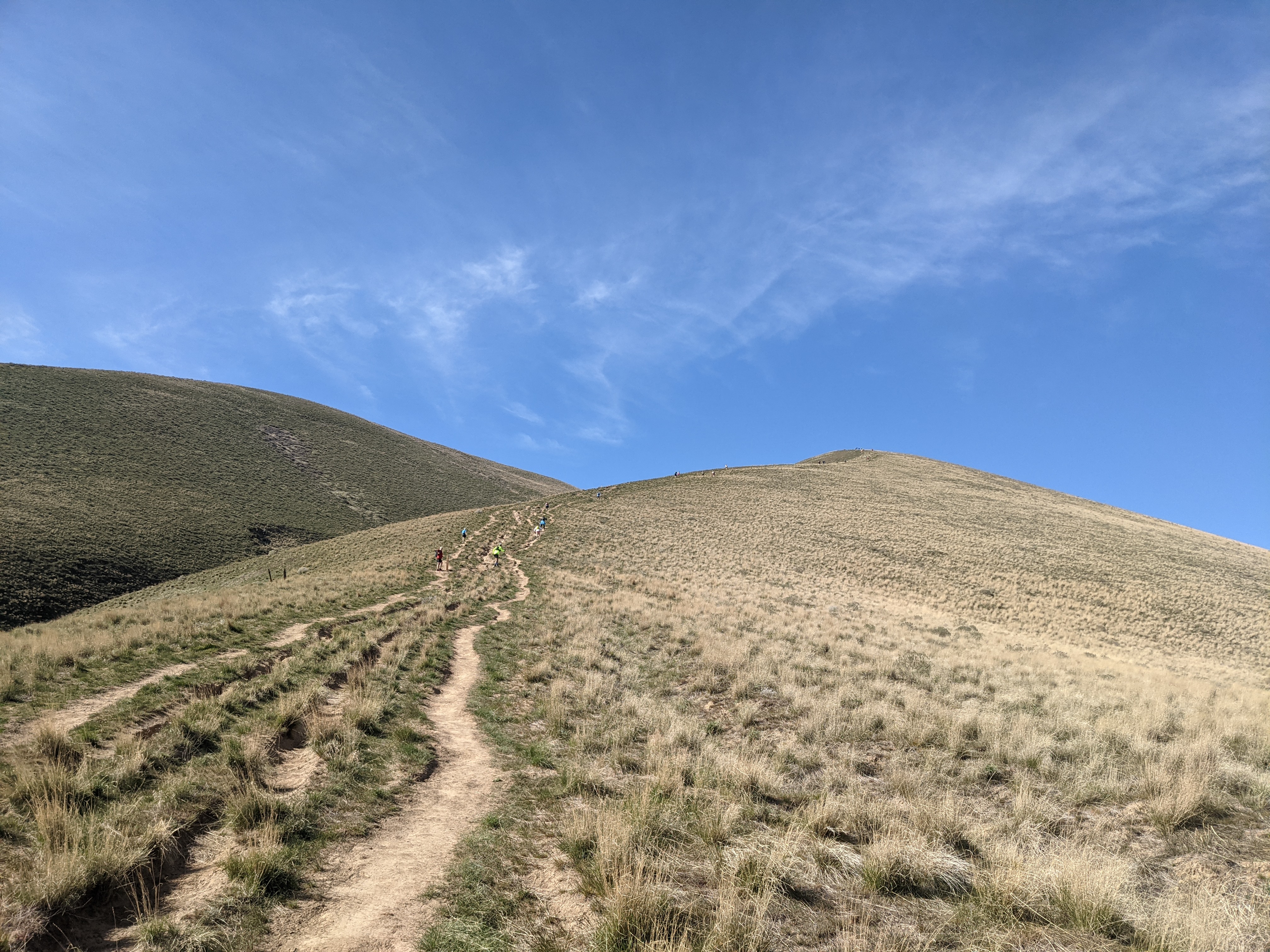
The start is easy and gives you a false sense of security.
The route turns off the road at an S curve and goes up a series of switchback cut for bikes. The dirt is loose and the trail bed tends to form a U making your foot roll as it lands.
Near the top of the ridge, I was on lookout for a trail coming in from the left (west) as it would be the return leg of the route meeting up with this trail before descending to the start/finish whence I’d came. The fork happened far enough from where my phone app said it would that I realized some of the trails might not be mapped in detail.
The ridge was covered in trees and brush so I only had peek-a-boo views of the sun cresting the hilltops above the valley as I began to descend the north side. The trail here showed evidence of having been maintained some time ago but had too many logs down to be considered runnable. One of the trail crew who I talked with after this hike told me it used to be called the Sheep Trail and had been used by fire crews to access one valley from the other. Access to the other valley is now most easily done via a dirt road. Just before crossing a knee deep stream, the trail disappeared and I was left to find that road on my own.
I scrambled up an embankment following a social trail which petered out at the top. Looking around, there was some flagging to my right (downhill) so I began to move towards it. The next piece of flagging seemed to indicate a route back down the river cut I’d just escaped.
Just because you see flagging doesn’t mean you should follow it. Bonus: find the flagging in this picture.
I checked my GPS and decided to pick a line in the opposite direction of the flagging. After pushing through some trees, I came across a scar torn through the bushes. It was road, though clearly unused for some time.
Much better than bushwhacking after some flagging.
I couldn’t help but think that the experience crossing Foggy Dew Ridge was an excellent way to put racers on notice as to the nature of this course as it’s not trivial to fit ~18,000 ft of climbing into 50 miles. That nature, however changed again with the road. The unused road led to a well used, dirt forest road which climbed either moderately or steeply depending on its mood, but always climbed. I found the road and it’s regularity to be an emotional release and pulled out a snack as I walked, realizing I’d been going several hours without refueling.
The road lead to a well used trailhead and a nicely maintained trail. This trail continued the constant climb through the trees but less steeply. It brought me to a campsite at a stream which I understood was intended to host an aid station. The Sawtooth Ridge 50 Miler clearly presents a challenge for course designers as there are long stretches which don’t come near roads. This campsite had a sign I’d never seen before, “Motorcycle Camp”. I’m guessing that the trail crew I’d seen the night before maintains many of these trails and so makes them easy to ride. Perhaps the plan is to bring the aid station supplies in by motorbike. While I appreciate the uninterrupted solitude of hiking in designated Wilderness (federal law prohibits mechanical aids – even trail crews have to use crosscut saws instead of chain saws), I found myself smiling at the thought that there was a place for dedicated group of motorbike enthusiasts to maintain a pleasant outdoors experience for themselves in a manner which also created good hiking experiences. I’ve been quick to slur “dirt bike” into “dirt bag” in places where two wheelers rip up beautiful, sensitive ecosystems and it felt like the motorbike community here was redeeming that image.
A sign I’ve never before seen in the backcountry but one which is well deserved here.
It was late morning and I ate a first lunch by a stream which ran through the camp. The early start and continuous walking were beginning to catch up to me, and I had many more miles to go.
From the motorcycle camp by the stream, the trail broke from the cover of the trees and started working its way upward through a field of granite. The views opened up. I put on my large sun hat as this was supposed to be the start of a heat wave there seemed little prospect of shade ahead. At one switchback, I heard rockfall in the small cut which the trail had reversed to avoid. I assume it was triggered by the rapid melt withdrawing the snow’s support from a precarious boulder.
Easier to see things without all those trees in the way.
The view from my second ridge top of the day was of a lake below a semi-circular ridge. It was an idyllic view with a dainty little trail cutting across the meadow beside the lake. I was trying to hike quickly but found myself taking too many pictures to exceed an ambling pace.
Lake below the route’s second ridge crossing.
The route switch backed down to the lake, then ran below the ridge for several miles, skirting alpine bowls. There were a few footprints and one set of tire tracks. The trail split in many places into a double track as frequently happens when the main trail channels water and so travelers form a second trail beside it just a few inches higher and drier. However, these two trails forked and I followed the footprints. I should have followed the GPS as I had to turn around when the trail ended at a campsite in a picturesque meadow. I’m still not sure exactly where I turned wrong as I ended up the proper trail by cutting down a dry creek bed.
This double track splits. Just because there are signs of previous passage doesn’t mean those signs point to your destination.
After passing a sign to the “Angel Stairs” trail which I was glad not to take as the name seemed to imply a long, steep climb, I found myself looking up at a low point on a ridge which would be the Prince Creek aid station in the race. Below it was a hillside covered in snow. While there had been some patches of snow thus far, the route had been easy to follow. I decided to try to stay on the switch backs under the snow and spent a great deal of time being excessively pedantic about staying “on trail” only to give up at the end and cut straight up the snowfield.
I think there’s a trail there. Not sure what races would do if they’d encountered these conditions a week later.
Apparently, more deer had passed this way than people. The ambition of the race directors to hold a race in such a remote area is fantastic.
Once set of human tracks. Several set of deer tracks. Apparently not a well used trail.
The race director’s ambition became more obvious at the top of the ridge. The map showed a three way intersection. I could see the trail I’d come up, if only because I’d just come up it. I couldn’t see any trail to the right. I could see a sign for a trail to the left but no trail to go with it. This was supposed to be the the most critical juncture of the race. Racers would pass through here twice. It was also the last full aid station and the only break in the final 24 miles.
Having now reached four of the six aid stations, I assumed that I was about two thirds done with the route’s mileage. That would be about 30 miles by 2pm which is excellent work if I do say so myself. The problem, however was that I felt spent and after spending some time with them map realized that there were about 25 miles to go. While this was a two day hike, I’d wanted no more than 15 left over for tomorrow. 10 miles after 2pm would normally be a reasonable proposition but I didn’t know if there was any more natural water on the course. Poor planning on my part; I’d glanced at the map and seen some valleys which I assumed would have a river in them. However, looking these new hillsides, it seemed clear that I’d underestimated their steepness, solar exposure, and it was quite possible that all the water had run off. The map appeared to show a traversal across steep hillsides not below the bowls I’d been walking through which had collected streams. Pictures of Lake Chelan tend to show brown slopes not lush hillsides.
A sign to no trail.
Eventually I struck out towards the trail to the left and eventually trail tread materialized. The map showed it meeting up with another, very steep trail in half a mile and I figured I’d try to go that far and decide how ambitious I was feeling. Apparently the answer was, “not very” because on encountering a rivulet next to a tree, I filled my belly with a second lunch, my bottles with later, and napped for about an hour. The sun kept moving and shifting the shade so it wasn’t much of a nap but it was nice to be off my feet. I did eventually get up and hike as far as an intersection with a trail which went straight up the still hillside above. The way ahead appeared pass through a large fire scar as far as I could see. I had a flight to catch the next evening and my faltering ambition failed for good. This would an 50km trip, not 50 miles.
I turned around and decided that after hiking hard this far, I’d have an easy afternoon and finish up the next day. I boot skied down the snowfield, and hiked back to the “Angel Stairs” trail, then sat down under a tree, ate a third lunch, and tried to doze off again.
The Angel Stairs trail turned out not to be quite so steep as I’d imagined but I took pictures as an excuse to go slow. The vista near the top was an overview of the latter half of the hike. I love these views which allow you to reflect on the distance you’ve traveled. The reverse view was of Merchant Basin, where the fall line trail I’d turned around at descended and then climbed up to meet the race course. It’s an alternate route which was so immediately inspiring that I found myself wondering when I could get back and walk it.
Sweeping views from the top of the last climb. Also, a good reason to take another break.
An enjoyable irony at the top of the last climb was a sign declaring itself at the summit… with the actual summit visible a short distance away. However, the mileages on the sign were a nice check as I’d been measuring things on my phone’s map app in only the most approximate way.
Actually, the summit is a little farther.
I decided to camp for the night at Cooney lake, expecting an easy hike downhill to wrap up the day. Of course when I got to the top of the descent over the lake, I had to boot-ski down a snowfield steep enough that to find the way down, I had to sneak right up to the edge and peek over to be sure it wasn’t actually a cornice.
There’s a trail in there somewhere. Boot skiing was fun though.
There were hints here and there where the trail peeked out from under the snow, so I played hide-and-seek with it until I found a campground just east of the outlet stream. The view was great and despite the heat wave happening somewhere, temperatures were perfect for the fleece, gloves, and beanie I’d brought.
Dinner was cold soaked breakfast and dessert since I wanted sugar and crunch not salty, soft noodles. I wandered around the campground and found the toilet which was facing passerbys and had a snow patch in front the way some thrones have a stool. Having the place to myself seemed ideal given the circumstances.
Putting the public in public latrine.
Sunday, June 27
I’d slept under my poncho tarp and so while I had a full setup to tear down, I was still out of camp pretty quickly. No need for breakfast as I was still full from the night before. I guess when you eat an oversized breakfast for dinner, it still counts as breakfast.
Early light creeping down the hills above the Cooney lake outlet stream.
I found a set of footprints in the snow leaving camp and followed them to the trail. I’d been hoping to use this as something of a training hike but without much mileage today and most of it downhill, I figured the only training to do was to try running. However, when I got to the point where the GPS said to start ascending Foggy Dew Ridge instead of following the valley bottom, there was simply no turn-off (I actually overran the point despite looking for a turnoff). I walked the trail several hundred feet before and after peering into the woods and found nothing. Then I tried cutting straight uphill until the GPS said I was above the trailand looked around for anything resembling a path through the trees. There was one pile of rocks which might have been a cairn but anything which might have been a route turned out to be an example of humans’ ability to see things which aren’t there.
Maybe a cairn, but if so, I could not figure out what it might have been indicating.
I gave up looking for the Foggy Dew Ridge Trail and ran the rest of the way out along the valley bottom. A motorbike had been up the trail and cleared out the deadfall, making my journey easy. “Course like water” is what running on a slightly downhill trail with a few roots and rocks feels like and so I repeated that phrase to myself until the trailhead came into view.
Since I’d found the toilet at Cooney lake amusing, I noticed that the trailhead toilet was labeled, “USE AT YOUR OWN RISK”. Apparently the Forest Service doesn’t keep as close an eye on these trail as the motorbike crews.
A trailhead toilet marked “Use at your own risk” – the jokes write themselves.
Running the few miles back to the car from the Foggy Dew Trailhead was smooth and fast. Emotionally it was a great finish despite the roller coaster of a course.
I took the afternoon off work so Lydia and I could get up to the North Cascades National Park Ranger Station in Marblemount in time to get permits before they closed. Unfortunately, I hadn’t packed and so we were about 10 minutes late leaving my place. The plan was to borrow a canoe (the Slick ‘Nanner) from a friend of Lydia’s. Lydia had some concern that strapping it into her kayak carrier upright wasn’t safe (most canoes are carried upside-down on cars). The straps felt tight and the connection seemed solid, but Lydia felt her car pulling to the right as she drove and so we took state highways instead of the interstate. After a while, I took over driving to experience the effect the canoe was having. It was less than the tire alignment problem my first car had had for over a year when I first bought it (I didn’t know what “tire alignment” was and just assumed the car was that way) and so I wound up driving most of the way.
Our schedule had been tight and so with the slower drive, we were going to get to the ranger station after it closed. Instead, we took our time and stopped by a restaurant in one of the rural towns on the way. Normally, I drive right through bent on getting to a trailhead or back home as quickly as possible so the change actually made for a pleasant afternoon. For sleeping accommodations, we explored a forest road which we’d been down the previous winter on a snowshoe trip (which didn’t happen because the road got dangerous once it left the river bottom). Back then, I’d noted some campsites off to the side and thought it would be fun to come back some day and stay at one. This was that day. Surprisingly, they were all occupied and we wound up pitching the tent on a spur road which ended in an unused gate.
Camping on a road to nowhere.
Saturday, May 29
I know that getting walk-up permits for campsites in North Cascades National Park can be competitive and so we were up a 4:45am to get back to the ranger station by 6am to stand in line for when it opened at 7am. It turns out they had a take-a-number system, so maybe we could have just grabbed one the night before. Also, we made good time and were there at 5:30am. The first competitor, a ski touring / mountaineering group didn’t arrive until 15 minutes later. No one with a boat showed up until after 6am. We cooked breakfast in the parking lot, then rearranged and packed things into Lydia’s giant blue dry bag. This being a canoe trip, we weren’t worried about bulk or weight. When things didn’t all fit, we just put them in extra dry-bags.
Making breakfast at the NCNP ranger station. Note the take-a-number system.
Being first in line did have it’s privileges and we got our preferred itinerary without contest. The one question was whether to put in at Diablo Lake and portage one mile around the Ross Lake Dam or carry everything down from the road directly to Ross Lake. Lydia has issue with her leg at the moment and so we decided on the portage as it was described as a well graded forest road instead of a windy and rocky trail (we’d hiked down to Ross Lake Dam before and could confirm). Then it was off to the gas station for gas, but really to buy a toothbrush since I’d forgotten to bring one. It took several trips to get down the short trail from the Colonial Creek Campground parking lot to the water. Not a good sign for the portage. As we paddled away under idyllic conditions, we noticed a boat launch which would have made the put-in easier. Coming from a hiking background, it’s strange to think that the goal is to not walk.
Lydia debating whether to bring shoes or sandals. It’s a paddling trip so why not both?
We passed under a bridge and then through a narrow boat passage in some kind of floating cordon. It’s been a long time since I’ve been in a canoe and I was in front so I decided to paddle four strokes on each side and told Lydia she could do the steering. She was fine at steering but it turns out we were both bad a navigating. As a dam and floating building appeared, I started looking for a place to pull out and start the portage thinking I was look at the Ross Lake Dam and the Ross Lake Resort. Of course, the Ross Lake Resort was supposed to be on the other side of the dam so I was a little confused but memory is known to be faulty. Also, the dam looked a little wider than I remembered Ross Lake Dam looking and the water was kinda high on it for being the down-stream side. Lydia identified the building as a a nature center on the map and we had to pull a >90 degree turn to get into the arm of Diablo Lake which would take us to Ross Lake.
Pretty mountain. Is that Ross Lake Dam? Damn! It’s not.
The arm of Diablo Lake which reaches out to Ross Lake, is a channel with steep sides. There were red boxes on the right and green boxes on the left, both with what appeared to be lights on top. I assume they were for navigation of some kind. There were also waterfalls. It was quite enchanting. A power boat passed us, slowing well before crossing paths and then speeding up thereafter which we appreciated as the wake might have rocked the canoe more than we’d have been comfortable.
The arm going to Ross Lake.
There’s a small dock which you come on suddenly at a turn in the lake (which sounds odd to say – there was no current like a river) shortly after a waterfall. It felt kinda like a secret place with just one road leading down to it and no visible buildings. We pulled the canoe out, pulled the bags out of the canoe, and debated how best to carry the metal mixing bowl of muffins (a canoe trip has it’s advantages, like bringing 30 muffins and a cake). Our first attempt at the portage was for us to put as much gear on our backs as we could, then carry the canoe together by grabbing the front and rear crossbars and walking in tandem. We were having to set it down ever ~100ft or so due to tired arms.
The Slick ‘Nanner at the start of the portage, muffins still safely inside.
A truck passed, slowed down to get a good look at us, then drove off. Lydia’s leg pain started. We’d gone maybe 10% of the way. New tactics were needed. We ditched the canoe in a rocky drainage ditch (pun intended) and carried all the gear we could, deciding to make two trips.
I volunteered to carry the muffins as a delicious counterbalance to the dry bags.
At an intersection, we descended to the Ross Lake Dam and dropped the baggage. Then we realized there wasn’t a way to get to the water from the dam itself. Damn! (sorry, that never gets old). In the pictures, we’re smiling, but you’ll notice that there aren’t any pictures from this point on the trip. We had lunch at the dam instead of at the lake as we’d hoped. We carried our gear back up to that fateful intersection and I scouted the correct route to the water. If only the signs pointing to the Ross Lake Ferry had been so obvious when we first passed. I went back and got the canoe which, oddly, was easier to carry by myself. The trick was to hoist it upside down with the middle crossbar laid across the shoulders.
An unplanned use for the towel.
In the end, we made it. Four hours to travel one mile. A rough introduction to portaging, though I expect that most introductions to portaging are pretty rough.
Lydia using the paddles as hiking poles.
As I was carrying the canoe down the final stretch to Ross Lake, I passed a car with a boat trailer. The driver was still there when I came down with the dry bags and we started arranging the canoe to put in. It turned out that this good natured fellow owned Ross Lake Resort. He motored off and just as we were about to put in, returned with beer for us. I guess it counts as trail magic even though we were on a road going to the water (lake magic?). He drove off to some errand and we left a muffin as a thank you on his foredeck.
Foreground: thank you muffin adorning a power boat. Background: Ross Lake Resort which floats .
Finally, at 2:30pm we shoved off and could begin the paddle up to Spencer’s, the campsite we’d selected for the night. The water was glassy. The sun was bright. It seemed a great reward after the struggle of the portage.
Yeah, the conditions were pretty good.
Ross Lake is oddly like a pond in that the wonder seems completely immobile. Flotsam will remain unmoved as you approach and pass. Waves seem to move the water up and down but don’t push it anywhere. So, despite there being water everywhere, we pulled off to a small cascade to get something fresher for drinking.
Lydia filtering from a small inlet stream. Ross Lake is oddly stagnant.
As we paddled, we noticed that brown forest service signs like you might see by the road were posted at boat-in campsites. There was something humorous about about it. They’re sensible, as campsites are tucked up in the trees and so hard to spot from the lake. It would be easy to boat past your destination. While it’s easy to follow the outline of the lake on a map if you know roughly where you are, we’d already made one navigational error despite having ideal conditions.
A road sign on a waterway.
Ross Lake was still in the process of filling up for the year and about 50 feet below it’s full depth. This meant that the boat ramps at many of the campsites were well above the water. We beached the canoe on a beach of coarse sand and tied it off to a stump. Having learned from the portage, it only took us two trips to bring everything up to camp, not the three it had to get the gear down to the water at the start of the day.
View from the boat ramp at Spencer’s.
In the late afternoon, while we were sunning ourselves on the boat ramp, we heard voices and spotted two inflatable kayaks dragging a third inflatable dingy with backpacks in it. These would be our neighbors for the night. I have an inflatable kayak and can say that paddling a canoe was a much better experience, especially because we didn’t need to tow a baggage raft and weren’t worried about popping our boat on the stumps and rocks near the shore. Their portage had been easier though. The fellows were pleasant and accepted our remaining beers as gifts from fellow adventurers.
Lydia found sticks and and stripped them with her hatchet to roast sausages for dinner. As a modern suburbanite, I’ve barely used a hatchet and am just learning the childish joys of whacking things with one.
Sunday May 30
This was a slow morning. The mountains above Ross Lake block the rising sun until it’s high enough to crest them and so the tent doesn’t turn unbearably hot shortly after daylight.
Our unique chore was gathering firewood for the next two days. Per the ranger who gave us our permits, collection of firewood, even dead branches, isn’t allowed on the islands where we’d be camping. The islands are small and so it’s reasonable to think that they’d quickly be stripped of anything burnable if foraging for firewood were allowed and so there would be nothing to return to the ecosystem for those islands. Driftwood is fair game but we hadn’t seen much of it at Spencer’s so we set about collecting enough firewood for the rest of the trip. Despite being connected to the mainland and relatively near two other camps, there’s no trail to Spencer’s so it still has the feeling of being on an island even if the rules are different. We piled the fuel on the groundcloth from under the tent so we could wrap it into a bundle and keep it relatively dry from the water which gets into the canoe as when we move the paddles from one side to the other.
Piling firewood on the tent’s groundcloth before wrapping it up for transport.
Our first aim after loading the canoe was to find running water to filter for drinking. The stream we found was cut into the banks of the lake despite the water level being low. I took this to mean that it had been this way before Ross Dam was put in. It seemed like a special experience to see part of a stream which only existed a “low tide”.
Lydia filtering water on the morning of day two.
Our destination for the night was 10 Mile Island which is about half way up the lake. Again, the water was calm and the day was warm. As we paddled north, we got a glimpse of Hozomeen, the dual-peaked mountain at the north end of the lake which is notable from Dharma Bums.
Lydia pointing to the west peak of Hozomeen. The east peak is hidden behind Desolation which has a fire tower.
Video of paddling towards Hozomeen on a glassy lake.
On the way, we explored up Devil’s Creek. This was much anticipated on my part, as I’ve hiked across the beautiful suspension bridge above it many times and always wished I could explore the deep, narrow inlet.
The bridge over Devil’s Creek.
It turns out that Devil’s Creek doesn’t got very far back before it becomes a shallow, creek draining over rocks which aren’t navigable. However, this arm of the lake is incredibly deep for such a narrow crack in the rock. The walls actually appear to widen underwater instead of forming a continuously narrowing V.
Devil’s Creek is deep. That’s not a reflection but the underwater rock.
When we reached it, 10 Mile Island, wasn’t an island because the water level was low enough that it’s connected to the near shore. We beached on a muddy, gravelly, shore below a kiosk visible from the water. Unlike Spencer’s and many of the boat-in campsites we’d passed, there was no boat ramp here. Lydia went on a walk around the island to find one and never did.
View north from where we beached on 10 Mile not-Island.
During lunch we decided that we’d brought a huge amount of food and should prioritize the heavy stuff – which happened to be all the vegetables, sauces, and dips. Lydia assembled the healthiest meal I’ve ever had in the backcountry. Somehow she manages to make healthy food taste good, which is something I’ve never mastered. This lead to the decision that more paddling trips should be in our future, just ones that don’t require portaging so we can bring things like almond milk and butternut squash soup like we did on this trip.
Our camp wasn’t on an island.
The sky had grown overcast and the air felt heavy like it was about to rain. Still, it was early enough in the afternoon that I wanted to try and explore up Lighting Creek. The route to Canada which starts on the east side of Ross Lake crosses a bridge over Lightning Creek, then follows high above the creek almost all the way up the drainage before taking a pass to the northeast after the ominously named Nightmare camp (on previous trips Nightmare camp has looked like a nightmare because it’s in dark, dense woods and is full of deadfall).
We hauled the gear up to camp then I set out by myself in the now empty Slick ‘Nanner. Sitting in the rear seat, it felt like the front wasn’t always in contact with the water. It handled very differently from when loaded, and was much more influenced by local currents. I had to spin around backwards at one point to get out of the small bay formed by the neck of land connecting 10 Mile Island to the shore.
Despite bouncing on the shallow undulations of the lake and the canoe always pulling to turn right, I made good time up to Lightning Creek. It wasn’t nearly as dramatic as Devil’s Creek, but I got to play a little bit with the current where the stream entered the still water. Like Devil’s Creek, this inlet didn’t go very far back.
As far up Lighting Creek as I could navigate.
The weather held and the trip back to 10 Mile Island was smooth, notable only in that I spotted some hikers sitting on a beach watching me paddle by. I tried to stare back just as pointedly to make things fair. Seeing other people, even if rarely, changes the feel of this trip from wilderness experience to playing in a large park.
There are two campsites on 10 Mile Island and we’d taken the better one. The other had a working bear box (unlike ours) but had grass growing up through the tent area which means it’s rarely used. Maybe that’s a consequence of there being no boat ramp. However, as with the camp at Spencer’s, the toilet appears new. It’s a made with coated metal framework and recycled plastic boards which look like the same material used in decking. The toilet paper dispenser was even full. Definitely the best latrine experience I’ve ever had in a national park.
We stayed up until the stars were out, sitting in our backpacking chairs next to a fire from the wood we’d carried in. Paddling trips are so luxurious.
Monday, May 31
For this morning’s water collection, we paddled across the lake and drew from a long cascade which we’d spotted the day before. As this was the start of our return journey, we decided to paddle down the other side of the lake to pass by a number of waterfalls we’d previously only seen from a distance.
Chasing waterfalls (to collect drinking water).One of the taller waterfalls I’ve ever gotten close to. This was just the base.
We were planning to stop at the Big Beaver beach, a campsite which we suspected to be particularly popular. On the way there Lydia’s leg started acting up so we pulled over for a snack on a rocky point.
The advantage of low water is that you can stop just about anywhere.
Big Beaver turns out to be where two creeks drain into Ross Lake. There were was a couple on the beach next to the lake but no one by either of the creeks.
A butterfly photobombing my picture of Lydia taking a picture.
We beached the canoe on a soft, slightly muddy beach near the outlet of the second creek. It’s water was clear and came tumbling down dramatically like Devil’s Creek had at the point where we couldn’t navigate farther. Despite having just had a snack, we ate lunch, prioritizing whatever seemed heavy. This time it was dolmas and sauce. Those things go down fast. Since we were expecting not have water on Cougar Island for the night, we drew water again before setting out for our last campsite.
The second creek at Big Beaver.
We’d seen the boat ramp to Cougar Island on the way outbound and it seemed to be on a steep, rocky shore. Instead of tying up near it, we saw two canoes on a shallow, sandy beach and tied off next to them while we scouted for the campsite.
The highway sign at Cougar Island. It felt kind of like Venice with waterways between our destinations.The Slick ‘Nanner where we’d initially tied off on Cougar Island to get the lay of the land.
I happened across several people at the first campsite who apologetically cleared out with little prompting. They were just passing through for the day. We got to talking and it turns out they’d been the other car with canoes on top on Saturday morning when we’d gotten permits at the ranger station. They’d carried everything directly to Ross Lake down the hiker trail and recommended it, though they also had their gear packed neatly in backpacking backpacks which might have made our experience easier too.
We’d gotten to camp relatively early in the afternoon and spent the time lazily. Lydia strung up a hammock, journaled and napped. I put out a chair and read nearby. Later we played in the lake, though I found it too cold to get very far in. This is strange because I have no problem charging into an icy stream crossing and usually have good temperature regulation. Lydia gets cold easily and yet loves icy dips.
Dinner was a funny affair since we’d already eaten all the heavy food and finally had to open packets of tuna and concoct more traditional backcountry fare.
After dinner we lazed by a fire, watching the colors in the trees, water, and mountains soften as the sun declined behind the western mountains.
Tuesday, June 1
Packing up this morning, we made a point to consolidate as much as possible for the upcoming portage. Some things were still left out loose and not everything could fit in the giant blue drybag, but having finished the firewood and overeating in service of weight reduction, two drybags disappeared into the larger sack during consolidation.
Lydia bringing the last of the odds and ends down to the canoe.
Of course, we had had to stop by a stream to filter water and this morning we had our choice of three streams just across from the island.
The paddle back wasn’t notable. We chose not to explore up Ruby Arm as it didn’t seem likely to offer anything we hadn’t seen at Devil’s Creek or Big Beaver. Some time, when we’re more accomplished canoeists, it might be fun to try to put in at the East Bank Trailhead (less distance to carry gear) and get flushed out Ruby Arm into Ross Lake in the swift current.
Just another idyllic day on the lake.
The portage back to Diablo Lake only took one hour, forty minutes this time with a lighter, consolidated load and the experience of how to move everything efficiently. However, I wasn’t able to figure out how to settle the canoe quite the same way onto my shoulders and it wound up resting on my neck which was sore for several days thereafter. Yet another reason to avoid future portages.
Navigating a road by canoe. Not to be confused with a giant banana slug.
The paddle back out Devil’s lake was pretty. There were a surprising number of people given that it was a a week day, even after a holiday weekend. When taking out, we used the boat ramp this time, and left sodas in the lake to cool while we packed everything into the car for a relaxed drive home.
This was a short over-nighter with my girlfriend, Lydia. She’s can’t walk as far as she’d like at the moment and so the relatively flat walk out to the river which starts the end of Icicle Creek Road seemed an ideal way to spend a night in the woods. This also made for a good excuse to dig out the 80 liter (or more?) backpack I got for $5 at a garage sale as my plan was to carry gear for both of us. I was training for a ruck race which I’ve since taken off my race calendar, so the heavier the better. It’s so big it has load lifters. I haven’t used a pack with load lifters in some time. We even too the pack’s brain off since it wasn’t necessary, though that was a bit unfortunate when it started to sprinkle.
The “papa bear” backpack. That may be hard cider behind the water bottle. You can fit lots of stuff in such a large pack.
The hike felt more like a walk in the park. We were on the lookout for mushrooms. Lydia has an intense desire to find Morels. One of the mushroom hunters she follows apparently mentioned finding some near pink Trillium. I don’t really know plants so Lydia had to point out what Trillium was. It seems to come in variations of white and purple so I’m still not really sure what a pink Trillium looks like.
Trillium in various shades of purple. Where are the pink ones? maybe with the leprechauns.
As with the moose antler episode, it turns out that Lydia is much more observant than I am and did find a morel (video). It had been detached from the ground somehow which apparently makes them no good to eat. It’s a pity because Lydia’s fascination with morels seems to stem from their delicious taste.
Eventually we reached the campsite at the intersection of Icicle and French Creek. It was our intended campsite because the bridge was out. At least it was out enough to prevent us from trying to cross that way.
Cross at your own risk.
Instead we lit a fire on a rock just below the confluence and sat in our backpacking chairs. The sound of the river downs everything out and so it’s easy to lose yourself in the experience. At some point conversation fell off, then a smile welled up across Lydia’s face. “I’m happy” she said. The hard cider might have helped, but it was a hard moment not to be happy even in the drizzle. When it was time to put the fire out, we simply knocked it into the river.
Fire on a rock, by a stream, in the rain. Smokey the Bear would be proud.
The sound of the river made for an excellent night’s sleep.
Sunday, May 23
The next morning, I attempted to ford the river since I wanted the experience of attempting a difficult crossing. My understanding is that river crossings is the second leading causes of death in the back country (bears, combined with all other predators, and still are less of a concern than insects – reference). Given that there is rarely a need to ford a river except when backpacking and backpacking trips tend to take you far from support, it’s a rare opportunity to practice a river crossing in relative safety (the car only being 1.5mi away). Some times fording looks much scarier than it actually is and I thought this might be one of those cases. Ultimately, I couldn’t quite get across because I couldn’t find solid footing mid-channel (video) and was too cold to try properly on another line. The water is all snowmelt right now my feet felt like they were on fire they rewarmed on the departing hike.
I’ve never done trail work and since we’d brought a hatchet, I decided to try to clear a log while Lydia looked for more morels where she’d found one the previous day. While I did hack through the log, it then fell on to the trail and I couldn’t drag it away. I’d already picked up two blisters and so I wasn’t about to try hacking through the log again to remove just the section on the trail. At least it was only shin high and easy to step over, not thigh high and requiring gymnastics.
Finished chopping through the near log. Unfortunately, I couldn’t get it off the trail. At least it’s easier to step over.
The rest of the walk back was short and easy. Lydia had finished her mushroom hunting and I caught up with her shortly before getting back to the car. The whole trip was unexpectedly refreshing given the short distance and extreme popularity of the nearby trail system (ie the Enchantments).
This was a short trip which I’ve been wanting to do since I realized that snowed-in forest roads were great for routes for cross country skiiing. Mowich Lake is an incredibly popular summer time destination, so much so that when some friends and I showed up there with reservations in 2019 on the Wonderland Trail, we wound up having to camp in the parking lot.
Mowich lake ski. Mowich lake is on the NW slope of Mt Rainier (not pictured).
April 4 – Saturday
WA 165, the road up to Mowich Lake, alternates between well graded dirt road and pot hole city. It’s almost as though the pot holes were intentional since the road doesn’t have washboarding, washouts, sliding or any of the other myriad infirmities which befall forest roads. Just before Evans Creek ORV Area (I previously assumed that the point of an ORV was that you didn’t need to take it to a playground), the ruts in the snow were just deep enough to threaten impassibility at any moment. Several trucks were parked along side the road so, when a clear spot presented itself, I chose to take it. It turns out I could have made it another ~1.5mi by car and so instead wound up carrying my skis. When skiing forest roads, there’s always a trade-off between having to carry your skis to better snow and being confident you’ll be able to drive away the next day.
The road looked a lot worse before this. For some reason they decided to pave after the pot holes.
The skis went on and off a few times as I tried to guess where continuous snow would start. Once I found it, the trips up to the lake was pleasant a ski of about 7 miles.
Mount Rainier NP is usually crawling with people. Apparently the “No Pets” sign has been mistaken as “No People”.
The snow was deep enough to provide easy passage over obstacles like gates and fallen trees. This is spring snow which is compacted and I wasn’t sinking in far enough to worry about my skis catching on sunken obstacles.
What gate?
It’s hard to go out in the winter outside a resort and not think about avalanche conditions. I was solo (a big no-no in avalanche terrain). The road cuts across slopes angled such that they are prone to sliding. However, the snow was compact and settled. Until I neared the lake, the snow on the slope above the the road was quite thin. There were some pinwheels but they were old. By the time I was near the top, the slopes above me were relatively short. Also, being on the road meant that unless something propagated off the flat road surface (unlikely due to settled snowpack), there would be no trigger for an avalanche. All in all, I have no idea if I’m correctly apply my Avy 1 training but tried to be conscious of the risks since I’m new to off-resort winter recreation.
Roller balls. Sign of potential avalanche conditions. These are old and and the snow was compacted.
The clouds were heavy and so there wasn’t much of a sunset, but I caught a glimpse at a switchback. The setup was such that I couldn’t tell as I was approaching the switchback if the road went straight and descended, wrapped around the hill upwards, or switched back. It just seemed to disappear after a crest. Once I got there, the answer was obvious but it was a little like the anticipatory thrill of approaching a pass and knowing you might see a whole vista on the other side.
As much sunset as I would see.
Getting to the Mowich Lake itself was a bit anticlimactic. First was the parking area which I recognized as a large flat expanse at the end of the road. The trails to the lake 50yds or so away aren’t discernable under the snow but there’s a large stream of open water whose snow banks were 5ish feet deep despite the water itself not looking very deep. The lake was less interesting: just an empty, flat white expanse. I couldn’t tell where the edge was and so stayed above it near trees.
Panorama of Mowich Lake. Not as grand as in the summer.
I’ve heard people say that there’s a ranger cabin at Mowich Lake. I looked around for one and nothing obvious stood out. The toilet facilities might look a little like a ranger cabin. They were buried above their doors. The roof had kept enough snow out that you could have sheltered in the pit it formed.
The toilets are not open for business.
As the light faded, I set up my tent. I’d only brought thin shepard’s hook style stakes betting the snow would be compact enough to use them. One pulled out before I had set it properly but otherwise the stakes seemed to hold. I compressed the snow before inserting them, then punched them and the surrounding snow some more before adding more snow on top and compressing it. I’ve heard you’re supposed to wait 15 minutes for the stakes to refreeze in the snow but I wanted to get in the tent so I didn’t give them that long.
For the first time I tried putting my boots and fuel can in the trash compactor bag I used as a water proof pack liner and then putting that in my sleeping bag to keep it warm. It was took a while before I could find a comfortable position for them. I should have scraped my pot with snow before melting drinking water in it. I ended up filling my water bottles with freshly melted salty ramen water. Oh well.
April 5 – Easter Sunday
I woke up to what I thought was the sound of rain on my tent and decided not to look outside. The forecast was for maybe rain and maybe snow so I decided to deal with whichever later.
My boots stayed warm enough to get into easily this morning. I’d brought bread bags to keep my fresh socks dry but they leaked quickly. Maybe good enough for an emergency trip out of the tent in the middle of the night but breadbags seem not to be as waterproof as they appear.
My tent survived the night despite being held up by trekking poles and guy lines (no traditional tent poles), something I’d never tried in snow before. This trip’s experiments generally seem to have gone well.
When I did open my tent door, I was delighted to find softly falling snow. I like snow and I like rain but I don’t like snow and rain.
My tent on Easter morning, looking towards the outlet stream from Mowich Lake.
The ski back to my car was just a couple of hours and picturesque most of the way. Initially the snow was grabby on my skis and the angle of the road wasn’t steep enough to let me glide. On the way in I’d used a walking technique since my legs are were still weak from the previous week’s endeavors and so I’d hoped the downhill on the way back would let me glide more. Eventually I was able to get some glide with each step but never got to the point of sliding without propulsion.
I’m no longer Christian but I still have an attachment to the impact it had on my life. This being Easter, some of the downhill travel was spent reflecting on this. Outdoors experiences have filled some of the emotional gap in my post-religious life with awe, wonder, and sometimes gratitude. Other experiences haven’t been replaced. Happy Easter.
Skiing back through softly falling snow in my own tracks.
The 50k version of the Badger Mountain Challenge was my first ultramarathon. It was a “long” 50k and now appears to be labeled a 55k. It seemed only fitting that my first 100 miler would be the full version of the same course. It’s a 23.5 mile outbound run over hills, ravines, and up onto a ridge. The return is 26.5mi because it comes off the ridge in a soft, shallow descent. 100 miler racers get to see the course once by day and once by night.
The course starts with two hills offering sweeping views of the Richland, WA area: Badger Mountain and Candy Mountain with an aid station at the base of Candy about 5mi in. After a steep descent off Candy’s west side, a tunnel conducts you under the highway, which is followed by about 3 miles of running on flat asphalt which begins to skirt vineyards. The Jacob’s Road aid station is relief from the monotony which continues for another 4ish miles in a section described in the race director’s opening speech as “the endless vineyards”. “The course always has vineyards on one side and sage brush on the other. If you’re ever running with vineyards on both sides, go back and look for [a course marking]” the speech continues.
What comes next is called the “Jeep Trails” which is accurate in that they do appear to be jeep trails. “Dragon’s teeth” might be more appropriate given the the angles at which you descend and ascend to cut against the grain of a series of about 5 gullies which vary from about 100 to 300ft deep. The Orchard aid station comes after the third descent and seems like a strategically placed lifeline in case a runner fails to adapt to their sudden encounter with the violent roller coaster of the Jeep Trails.
After the Jeep Trails, comes a short section of road which turns under a bridge then climbs steadily to the McBee aid station. This sits at the base of a wicked climb of about 1,100 ft in less than a mile which at points is steep enough that you can’t tell how close you are to the top. Atop McBee ridge, a rocky, hard-packed dirt road runs several miles out to Chandler Butte where an aid station provides a respite before returning you around. The trip back to the bottom of the ridge starts by running the way you came while trying not to stub your toes too often. Instead of descending the steep climb, there’s a gradual, soft single-track which brings you down over about 3.5 miles. From there, just get back to the start line the way you came (about 19mi) and you’re half way done.
The race manual warns to be prepared for temperature swings from of 40F, wind, hail, snow, etc… citing recent years when finishing percentage was close to 1/3 or 2/3. I carried a lightweight raincoat, full weight fleece, sunglasses, beanie, and gloves. Between those and the buff and heavy tights I wore the whole time, the elements weren’t much of a factor. I overheard some runners complaining about the cold and wind on McBee ridge (it was cold enough to see your breath) but frankly, we seemed to have had an easier year.
A Good Start – Friday Morning to mid Afternoon
Due to COVID-19, runners started in waves of 10. My wave was at 7:34am. The race director gave the same speech I’d heard him give to the last several waves, then we waved through the starting line without much fanfare.
The climb up Badger was gentle. It’s a usually steep enough to keep me at a walk with opportunities to jog briefly on some of the flatter swtichbacks. The sun was rising over Richland and the view was sweeping but enjoying the view meant looking away from the course and I was full of energy and excited to be marching as fast as I could. The hill is short – a little under 1,00ft – and so it didn’t feel long before the hill rolled over in to a traverse and then descent. Like any footrace, the opening miles are something of a sorting process as groups of similarly paced runners begin to fall in together. That effect was dragged out due to the waved starts.
The climb up Candy was similarly gentle and felt relatively short. Training and experience have done much in this regard as I remember feeling as though I’d gone a much greater distance at this point in my first ultra. While charging down the steeper and mildly technical back side, I caught up to a fellow named Kevin who I hit it off with and slowed slightly so we could run together as company would be welcome in the monotony of the Endless Vineyards. A woman I’d been leapfrogging caught up. Her name was Natalie. The three of us coordinated fist pumps when we saw a photographer and generally passed the time in conversation until the Jacob’s Road aid station.
At this point, I was attempting to use aid stations as collection points only. I’d extract my soft bottle from my vest and have it open when I reached the station. We had to wait to have our bottles filled by a volunteer – we held the bottle, they held the pitcher – to avoid contact. I’d then ask for two gel or gummy packs (“ask, don’t grab” as one sign read), and then be on my way. Eating and drinking were done in motion. Resting was to be done by slowing down, not stopping. This got me out of the aid station quickly, but left me looking to make new friends.
That connection was easy to make. A fellow I’d seen on the way up Candy (I’d nicknamed him the Jolly Green Giant because he was tall and wearing a green shirt with only one arm through) was my next target for conversation. His name was Ryan and we made good time through the vineyards while talking about running. When the ground suddenly fell away into the first of the ravines which make up the Jeep Tracks, we both seemed to take a boyish delight in bounding down the steep, uneven dirt. Ryan tripped, rolled, bounced up, fell back into stride then joked that it wasn’t a trail run until you’d taken a fall. He was a slightly stronger runner but I’d only fall behind a few steps and was able to catch up in the transition back to running after each climb.
After leaving the Orchard aid station, Ryan overtook me. I thought he’d gotten out ahead and I wasn’t expecting to see him again. In fact, they’d had his preferred energy drink and he’d wait a little extra to get it. After finishing up the Jeep Trail together, he said he wanted to eat and change out gear at McBee and so took off ahead.
The McBee aid station was busy and my stay was brief. I saw Ryan but he was still swapping out gear so I left without him. The climb had been visible as I was approaching the aid station. Runners were like a line of ants slowly crawling up a steep mound toward some common destination in the sky. Soon this was my fate. One great convenience was that footfalls had worn steps into the hard dirt which had resisted erosion enough to remain firm underfoot. This made the experience a little more like stairs and less like the loose Jeep Trails. At some points the angle was steep enough that in places, the “runner” (we were all walking) would disappear “over the top” but when you got to that top, the hill just kept going up. Ultimately, though, hills don’t get taller and so through consistent application of forward motion, I got to the top where there was a pile of walking sticks for public use – the kind of think you’d use for climbing a steep hill.
Straight up. That’s how you climb McBee ridge.
McBee Ridge is wide and rolling with a dirt road embedded with fist-sized rocks which didn’t move when I accidentally kicked them. I’m sure there was a beautiful view but I was mostly watching my feet. While the climb had gone quickly, it had left me with some pain in the right hip which only came out as I tried to reorganize my limbs for horizontal – instead of vertical – motion. I was also getting hints of a recurring issue I have on my right buttock near the tailbone – an ache which can occur on each step and a Sports Medicine doctor once told me might be related to my sacrum as part of my body compensating for an impingement in my right hip socket. For the first time in the race, time seemed to pass slowly. The Chandler Butte aid station wound up being one bump farther on the ridge than I’d thought. Still, I was in a good frame of mind when I got to the psychological quarter-way-point of the race.
The return along McBee ridge started with seeing Ryan, Kevin, and Natalie, all less than two miles out from Chandler Butte. While the out-and-back style of the course is repetitive, it provides for greater social opportunities. Seeing and acknowledging people you ran with earlier is one of the great joys of an event like this. The greatest connection, though, was when I overtook Lance, a mile or two before the descent from McBee ridge. It took a few minutes of chatting to put it all together but we hard run a section of the 50k together two years before. We’d run out of energy, eating something (I distinctly remember “deploying my emergency Snickers”), and then suddenly being able to run again – both at the same time. We hadn’t remembered each other’s name or much of want the other looked like which is why the connection wasn’t instant but it was an incredible connection to make. We’d both been planning on running the Badger 100mi last year as our first official hundreds and both wound up running unofficial 100s instead. He’d done 147 laps around his neighborhood for charity. Eventually, we spotted the soft single-track which would take us back to the McBee aid station at the bottom of the ridge. I let it carry me like a dream and pulled away from Lance.
The descent off McBee ridge and the return along the valley to the aid station was the only section of the course without any hint of a wind. There was vegetation, which had been sparse elsewhere and this held the heat. It wasn’t a particularly hot day but it was approaching the heat of the day and I was beginning to feel warm. I was wearing heavy tights for warmth from the morning and had a buff around my neck which I’d need at the aid station. My stomach was beginning to be upset. I’d only eaten gels and gummies. I was beginning to get sore legs. The pain in my right-front hip was now on the side and the sacral issue was slight but persistent.
Back at the McBee aid station, I kept things brief like I had at all other aid stations but thinking my stomach needed something besides engineered food, I asked if they had “real food” (runner language for something you might eat if you weren’t on a run). Grilled cheese was on offer but that didn’t sound right. Instead I asked for two packs of energy gummies and a the volunteer gave me a concerned look and asked if I’d been eating enough. “Two pack of gels after every aid station” I replied. Part of the art of ultrarunning is diagnosing and fixing things which go wrong. For example an upset stomachs can be due to too much or too little food and exacerbated by heat. Unfortunately, the line between too much and too little is a hard one to determine for me 200Cal/hr is too little but that takes a long time to manifest. 300Cal/hr is too much but I have less experience overeating. Was I just hot? I felt warm but wasn’t sweating. It was disconcerting to know that my discomfort was showing in my demeanor. I jogged down the road feeling crummy and decided to start my return through the Jeep Trails by slowing to a walk. Something wasn’t right in a “this will spiral out of control if you don’t deal with it” kinda of way. I was questioning why I’d ever signed up for this event and was pretty sure I never wanted to again. I’d just cancel everything else I’d signed up for and tell my friends it just wasn’t worth the pain when ultrarunning had only ever been a replacement for thru-hiking.
When I walked in to the Orchards aid station less than two miles into the Jeep Trails, I announced I needed a reset, found a chair, and asked for water I could pour on myself, and ice I could put in my hat. In this context, “reset” was a well understood code word for, “I have a problem and I can’t leave until it’s fixed.” Fortunately, I was the only runner present and had the attention of all three volunteers. One gave me ice for my hat. Another came over with a pitcher and after refilling a dixie cup which I immediately drained several times, asked if I wanted the water of my head poured slowly or all at once. These volunteers had clearly seen this kind of thing before. The only real food they had was grilled cheese so I nibbled a slice trying to figure out what was wrong with my stomach. The pain in my right hip wasn’t as present since I’d walked in but it had prevented my body from relaxing while in motion since each step required bracing either mentally and physically and I’d had to focus on not favoring the hurting leg and so cause more problems through bad form. As I now began to relax, I realized I was about to cry and leaned in to the feeling. I realized that I was beginning to notice things in the world again – I’d had tunnel vision. I’d taken my sunglasses off at some point but hadn’t noticed that it was brighter until I’d started crying. A volunteer came over to check on me and I told them that the right thing was happening and I just needed to cry it out. After the crying, it was clear to me that I’d been over eating. My stomach wasn’t completely settled but now I could tell that it was full not empty. It turns out that two packs of gummies is 320 Cal and I’d been ahead of schedule and so hitting the aid stations faster than one an hour. Lance and Ryan both came through and both asked if I was heading out – an invitation to join them. I declined, explaining that I needed to take it slow for a while. I filled one of my 500ml bottles with ginger ale and decided to walk to the next aid station, 5.5 mi and two steep ravines away and then re-evaluate.
When my watched next beeped, it said I’d taken 30 minutes to do the mile containing that aid station. As one of the volunteers said had, “that was pretty quick for someone who was talking they way you were when you came in”.
Goals
My the time I’d returned to McBee aid station from the ridge, I had built up a lead of 45min over the 10hr pace I wanted to hold for the first 50 miles. This was my first race with time goals.
A-level goal was 20hrs which I’d picked because it was a simple projection from my training runs without accounting for fatigue. I considered it out of reach but wanted to go out chasing it because I’ve traditionally run ultras for enjoyment, not time, and quickly learned that going out fast was a quick way to kill the enjoyment. While going out easy means you have fun, it also leaves you wondering if you might have been able to go faster.
B-level goal was 24hrs. 24hrs is a common target for newer ultra-runners. It’s too fast to walk the whole race (except perhaps for perfectly flat courses) or spend too much time at aid stations. Badger claims a 13,000ft gain over 100 miles which is toward the lower end of 100 milers but also claims a course which is more difficult than at first glance. There’s a special buckle for sub-24hr finishers.
C-level goal was just to finish before the 32hr cutoff.
At first, I tried to let go of the goals. I needed to relax, let my body stabilize, and get out of the Jeep Trails and into the Endless Vineyards where the hard, level road made moving easier. I was able to climb and descend methodically. My muscles were still strong, just a little sore. My stomach was feeling better but was still skittish. Ambition began to creep back in. I’d built up enough of a lead that I might still be able to finish the first 50 miles in 10hrs. That might not mean anything about the second half. In fact, it might mean pushing too hard and throwing away my chance to recover and go sub-24. Still, if I could finish the first half in 10hrs, then maybe I could walk the second half in 14hrs? I got out of the steep, soft Jeep Trails and onto the hard, flat asphalt of the Endless Vineyards and started walking as fast as I could.
The Long Walk – Friday afternoon
I walked the next 30miles except to jog downhill on the easy grades of Candy and Badger mountains. I stopped at aid stations to sit and eat until my stomach was ready for the next section. I was back to basics: stay healthy, stay happy, walk hard.
I made it back to the Start/Finish aid station (cruelly named as it’s the half-way point for the 100 milers) and spent half an hour eating a “real dinner” (four quesadillas) and cleaning my feet (minor blisters but lots of dirt). I’d made it in about 9:57 elapsed time and held off a 50 mile runner who had started to close on the final descent, but the mile which contained dinner cost 40 minutes.
A strap which held my running poles onto my vest had broken on the return trip over Candy and since I now had to carry my poles anyways, I was glad to be walking. It’s not clear exactly why poles make walking faster on flat ground. There are certainly circumstances where they don’t. You’re not as nimble with them which is a penalty on technical terrain. Badger doesn’t have much of that, though. On the flats, I think the rhythm and forward shift of my body keeps me an a more aggressive mindset than without them. While poles are certainly practical to reduce stress on the legs during climbs and descents, their psychological benefits may help shift the average pace up just a little. I usually don’t feel like listening to music which many people lean on for moral support and so it was the click-clack of my poles on asphalt and the shoom-shoom of my poles in dirt which kept me walking quickly as night fell atop Candy Mountain and I walked outbound again past the Endless Vineyards and through the Jeep Trails to arrive at McBee aid station for the third time.
The world goes to sleep. Running west from atop Candy mountain.
Night on the Ridge – Friday night to Saturday early morning
I think it was shortly before midnight when walked in to McBee aid station. I stopped this time, asked a real food, went with the offer of butternut squash soup, and extracted from my drop bag a liter of my chai my girlfriend had made. I’d been babying my stomach throughout the afternoon. Only run on the downhills. Don’t leave an aid station without the stomach’s permission. Butternut squash soup was a new offering available only at night and at the better stocked aid stations. I’d been saving the chai for the night knowing both that its light, sweet taste would be tolerable with even the most upset stomach after a day of drinking sickly sweet soda and chemical tasting electrolytes. Caffeine wouldn’t hurt either. Lydia puts 3-4x the recipe’s recommended number of tea bags into the pot of spices when brewing her chai.
The McBee climb went well despite lacking fresh legs. The walk along the ridge was windy an brisk but I felt clear-headed and focused. Just before Chandler Butte, I saw Ryan who recommended the butternut squash soup. I had more of it. The return along the ridge also went well. The lights of the city in the valley to the north were bright but I was mostly in the pleasant flow of quickly placing my feet without stubbing my toes.
Since before the McBee aid station, I’d been running calculations to determine cutoffs for each aid station such that, if I arrived after the cutoff, I would have to run if I were to have a hope of finishing in less than 24hrs. The idea was to walk as long as possible on only run when I had a clear deadline to justify the effort. I also had to adjust the distance on my GPS watch against actual distance on the course as my GPS watch recorded 52 miles in the first half of the race and continued to creep ahead. Just after starting the descent off McBee Ridge, I realized that I’d missed a mile in my calculations and walking as long as possible was giong to put me in a tight spot. With the most runnable section of the course under my feet, I decided to see how it felt and surprisingly, it felt good. I overtook the runner who I’d allowed to start the descent before me on account of his intention to run it and my intention to walk it. Along the valley I overtook a couple whose headlamps I’d seen turn off the ridge and start the descent. I even overtook Ryan and a friend of his. I stubbed my toe and almost fell while doing so. I was glad he knew me because having someone suddenly curse loudly behind you in the dark might not make you amenable to them.
Back at the McBee aid station, I felt good. No nausea or hip/butt pain, just sore muscles. More butternut squash soup. Drain the chai. Off and running.
Running it In – Saturday early morning to sunrise
I didn’t push it in the Jeep Trails and I stopped at each aid station to sit and make sure my stomach was ready for the leg to the next aid station. I was ready to drop to a walk if my legs showed signs of tiring but they jogged along, knocking off miles at 11 to 12 minute intervals.
At Jacob’s Road, the old lady who brought me two cups of butternut squash soup said she’d run the 100 miler two years prior and explained that while next climb was steep, the wind was at your back so it wasn’t so bad. Even the wind, once any enemy, was going to be willing me home.
The pre-dawn light at the top of Candy Mountain was beautiful. It was the first time I stopped to take a photo instead of trying to manipulate my phone while running.
The world begins to wake up. Running east from atop Candy mountain.
I stopped at the final aid station at mile 95 to eat a little. In another race, I once had my stomach turn over during the last four miles which should have been a sprint and so wanted to play it safe. With one hour fifteen minutes still on the clock, 5 mile and 1,000ft (rounded up) to go, a sub-24hr finish was mine to loose, not mine to gain, and so precautions were in order. Unfortunately, the final aid station was snacks only, no butternut squash soup. I asked for a pack of gummies and a volunteer brought one, then jokingly asked if I wanted a beer. There’s a long history of alcohol near the end of ultras and I was feeling good and cocky and so went for a shot. He poured me a dixie cup of Rainier which I drank. Then he asked if I wanted whiskey. I assented, but only one finger’s worth. He poured it. As he did, Ryan came running by the aid station. Ryan is tall with a strong build. His stride was easy and powerful. He carried long running poles balanced in the middle in each hand which drew clean arcs as his arms as though they were weightless (mine draw a linear motion through the air like XC skis to minimize the weight of their bounce). It was a glorious sight. He called out his bib number once, loud and clear without breaking stride. The volunteer who’d just poured me a whiskey said I should go catch him. I said nope and shot the whiskey. Surprisingly, this and the beer put the perfect feeling of fullness and satiation into my stomach. I thanked the volunteers and jogged off to walk up Badger mountain for the last time.
A trouble maker making trouble: beer before liquor at mil 95.
It was now shortly before 7am and the 50k had started. Runners in yellow bibs were making their way down Badger Mountain as I went up. Many said, “good work” with much more enthusiasm than we 100 milers had used in encouraging each other. A few young women whooped and shook their hands in the air as they passed. A middle aged woman stopped, took my arm, pointed at the sunrise and said that it was coming up just for me. That last one was a little much.
Just before the climb leveled into a traverse, I quickly looked back and spotted one or two runners working their way up below me. They looked to be walking and so I figured my position was safe as long as I ran anything which wasn’t uphill. A few minutes later, I heard loud, thrashing, rhythmic music, footsteps and a young man in bright green pants used by road workers ran past. He had been running uphill and continued to do so. I chased for about 50ft but even when the rolling traverse descended, he didn’t merely let the hill carry him as I did, but attacked it, increasing his pace. For a second time in the last leg of this 100 mile race, I was thoroughly impressed.
As I began the home stretch, a long set of switchbacks down Badger Mountain, more waves of 50km racers passed. Some were running uphill as fast as I was running down (3rd time I was impressed). One runner (who was hiking), I recognized from the 100 mile race – I’d seen her outbound from the 50mi as I was coming in to it. She’d finished sub-24hrs and then put on a 50km bib and started up Badger for the 3rd time. “Didn’t you run the hundred?” I called out as we approached each other. “Yes” she replied as we passed. People are incredible (4th time).
Eventually, I made it down to the concrete at the bottom of the hill. I got to sprint hard for the 20 yards up the finishing chute to the finish line. I held my poles over my head in one fist and whooped and hollered. The race director asked when I’d started, I told him, and after consulting his clipboard, gave me a sub-24hr buckle.
Epilogue
I’d hoped to congratulate Ryan but I didn’t see him around the finish area. I did see the young man in construction pants and gave him a hearty retelling of his finish from as I’d experienced it. He returned the compliment saying how hard he’d had to work to catch me. After making the acquaintance of Kevin, Natalie, Ryan, Lance (again), and others not mentioned here, it was wonderful that even at the end of the race you could connect via mutual admiration and appreciation for a shared experience.
The Chewuch River Loop is an easy going snowmobile trail which is infrequently traveled and so made for great skiing. Because of the tracks they leave behind and loud, smelly nature, snowmobiles are your friend if they were in the area, but aren’t now. The weather was perfect but there weren’t any large views because the trip was in a forested river valley along a snow covered (most of the time) forest road. Notable events included finding a moose antler (aka “moose paddle”), learning why you shouldn’t light a canister stove in a closed vestibule, and encountering horseback riders in the snow.
Route started from the Eightmile Sno Park and went counter-clockwise. Orange = Skiing a plowed road
Saturday (January 16, 2021)
Lydia and I arrived at The Eightmile Sno Park without having settled on which of the routes we’d discussed, we were actually going to ski. The discussion dragged out a little as neither of us really wanted to leave the warm car but eventually we settled on doing a loop from the Eightmile Sno Park, counter-clockwise starting by skiing the road we’d just driven in on. This would get the bad skiing out of the way first as hopefully the rest would be the “Groomed Snowmobile Trail” which the WA State Parks map promised.
As cross country skiers, we have a love-hate relationship with snowmobiles. They’re loud, smelly, and hog the trail. However, their treads and skis groom the snow and make for a much better XC ski experience than when breaking new trail. Our hope was that this route would be less popular, but still popular enough.
We got out of the car around 10am and things started well enough. The toilet at the Sno Park was open. The herd of snowmobiles which were idling when we’d arrived took off up a different trail. While there wasn’t the groomed trail south along the road as the map implied, the road initially had enough snow that I didn’t feel like I was damaging my skis.
The Chewuch River viewed from the road shortly after leaving Eightmile Sno Park.
Unfortunately, the plows had down their work well. While that had made driving in easier, it made skiing less fun.
Lydia skiing the road.
There was a thin layer of ice which usually kept the skis from making direct contact with the asphalt. When we turned east to cross the Chewuch River though, the road had been sanded which made for a feeling like skiing on sandpaper. I’m surprised my ski bases aren’t worse off. It also made for a loud sound like a zipper.
This road skiing lasted until the Boulder Creek Sno Park where a shoulder of the road had been left covered in snow and a clear snowmobile track was present. We took this shoulder which disappeared shortly at a one-lane bridge over a drainage coming in from the east. There was a little snow on the road as the road returned to the bottom of the river valley.
We were now well into the section where the the groomed snowmobile track was supposed to have picked up. The road skiing was hard on Lydia’s knee, still sore from the road walk on our previous adventure. We decided to go for another 20 minutes and if conditions didn’t improve, we’d abandon the endeavor and ski the 4-5mi back to the car instead of sticking it out for another ~18mi over two days. About 15 minutes later, the plowed road turned west toward the river. I was ready to turn around early since it seemed obvious that this wasn’t going to get any better when I realized that the plowed road wasn’t the main road. It turned onto private property. Another road continued straight, through a fence, but was snowed under with signs of a single snowmobile’s passage. That was our route.
The snowmobile track was soft underfoot, each kick (and yes, we could glide now, if only a little) sinking in subtly like walking on a deep carpet. The sun was shining. It was blissful after the miles of skiing on barely covered asphalt.
We ate lunch a little later sitting on the bank of the Chewuch with a view up the river back to the Eightmile Sno Park on the other side where we’d started. To avoid sinking in to the deeper snow where we ate lunch, I tried to get off my skis and onto my backpack and from there flop over to my foam sleeping pad. I’d only brought running gaiters which didn’t have a strap underneath and didn’t want snow up my pants or trapped under the gaiters melting into my shoes. Unfortunately, when reversing this sequence of acrobatics after eating, I slipped when trying to go from backpack to skis and so fell in anyways. Oh well.
Looking back whence we started while lunching on the other side of the river.
The going continued to be pleasant. The skiing was easy. The light was soft for the few more hours we had it (sundown around 4:30pm). Lydia guessed that the trees we were passing were Ponderosas. My botanical knowledge allows me to differentiate between a tree, bush, and grass.
Nice, snow covered forest road.
We hadn’t seen anyone for a few hours and the snowmobiles we’d seen at that time had been loud enough to give us plenty of warning. About half an hour before sundown, I spotted two snowshoers without packs rounding the next bend toward us. I interrupted Lydia with this development which turned out to be a good thing because she was just about to loudly proclaim how loud we could be that evening with no one around.
The snowshoers were a middle aged couple who owned a cabin up the road, near a spur where we’d intended to camp. They said no one else was in the area and people wouldn’t mind if we set up a tent. They were quite friendly and it seemed like they might have invited us to their cabin if it hadn’t been for the pandemic. They were responsible for the lone snowmobile track which had eased our passage thus far. The unfortunate implication of this was that the track might not go for our entire route.
Lydia and I continued and just before sunset the snowmobile track turned left on a spur road just as the plowed road had turned left earlier in the trip. The land was slightly sloped so we continued a short distance to the top of a gentle rise, breaking a shallow trail through a 1/8″-1/4″ thick crust of icy snow over several inches of loose powder. As we only went a short distance, this was fun as the crust made the sound of breaking glass when shattered by a ski in motion. My skis would sometimes get stuck under the crust and scrape on the bottom side before busting through. It was a little difficult to find a flat spot to camp because the crust had filled in holes and bumps but once broken, the powder would compress to match the undulations of the forest floor. I’m used to tents which are set up with trekking poles and guy lines making them difficult to move. It was very convenient to be able to pick up Lydia’s tent with it’s internal tent poles and reposition it around obstacles as we found them.
Setting up the vestibule in which I blew myself up while melting water.
As a new winter camper, I took part particular pleasure in sticking our skis into the snow as tent stakes the way tents look in photos from intense expeditions. With the snow so powdery under the crust, conventional stakes could not bear much tension even after compacting the snow and waiting 15 minutes for them to solidify.
Lydia had gotten in to the tent first so I could use her skis as the back stakes and only have to flounder around knee deep snow of the tent’s vestibule after using my skis as the front stakes. Since I was occupying the vestibule anyways, I figured I’d melt water for drinking since our plan was to cook in the vestibule. I zippered the flap shut, sat down in the tent’s door (having a sunken vestibule makes getting in and out of a winter tent much easier than a summer one), connected a gas can to the stove (carefully placed on a foam pad so the snow wouldn’t cool it and reduce the pressure), and then tried to light the stove. Melting snow was taking a while so I started a second stove. The gas pressure in the first died down and so I used the flame from the second stove to heat the gas can for the first (just enough to melt the ice – gas cans cool themselves to below freezing). Thus, I survived my first bad idea involving gas and fire.
Re-lighting the stove took several attempts. My lighter had trouble catching. Then suddenly, WHOOSH. I’d had the gas line open while trying to light the stove but the vestibule door shut. The air-gas mixture must have been perfect all I saw was a flash and felt a strong heat hit me with a soft thud then dissipate. Closing my eyes must have been an unconscious reaction otherwise they might have been burned but they were immediately open again trying to figure out if any of the lingering flames were the tent itself on fire. If the tent were on fire, I needed to forget fire fighting and get out of the tent and get Lydia to do the same. After a second or two’s assessment, the tent itself didn’t seem to be on fire so I righted the stoves (a liter of almost melted water was lost), trying to move quickly. I remember batting some small flame with my gloved hand and it went out. Then, I realized that one of the fingers of my glove still had a candle sized flame that hadn’t gone out when I’d batted out the other flame, so I yanked the glove off and threw it out under the edge of the vestibule into the snow. Situation in hand, I set the pots on to melt more snow.
Over a dinner of rehydrated rice and mushrooms, Lydia told me that the right side of my face smelled burned but not the left side. Whenever I rubbed it, little flakes would fall out of my beard. My eyebrows were still attached, though a few strands felt fused. I’d blown myself up, just like in the cartoons.
Sunday (January 17, 2020)
I’d brought a dry bag and kept my boots and fuel can in it at the bottom of my sleeping bag which made it easy to get going in the morning. I’m not used to splitting a tent with someone and when I’m by myself, my stuff and I tend to expand to fill all available space. I was pleasantly surprised that Lydia and I didn’t seem to get in each other’s way while packing up and making breakfast. The only hard part was getting the short distance back to the road on the icy snow where the scales of our skis didn’t catch. The trick seemed to be redefining skiing as an upper-body exercise since planted poles didn’t slip. Also, balance is hard with a loaded pack.
Lydia demonstrating the difficulties of trying to get fish scales to grab ice-hard snow.
We were now on a section of road which had not seen a snow mobile recently and so were breaking through the same crust I described yesterday. The joy of pretending I was a bull in a china shop, breaking glass with each step, quickly wore off. The going wasn’t hard, it was just slow and loud. Even a one sentence observation required stopping and then waiting for the other person to stop before speaking.
After about half a mile or so, some snowmobiles passed us going the other direction. Odoriferous though they might have been, the skiing became much easier as the trail was now broken. Shortly thereafter, we came to a place where an open stream was crossing the road. Fortunately, it was shallow enough and ski boots sufficiently waterproof that our feet stayed dry.
An open stream crossing concrete roadway.
After skiing a little farther, we came on a sign warning us about the hazard we’d just crossed. I’m used to water on roadway in the spring runoff. It was unexpected in the winter and made me wonder how often that part of the road is dry.
Would have been nice to see this coming from the other direction
The entire morning, there had been a set of tracks in the snow which I’d assumed were boots from someone walking. They’d been walking a long ways. It turns out that I’m not very observant because they were probably moose tracks. At some point, I noticed Lydia had stopped a bit back and was waving a moose antler. I had skied right by it. Lydia had been watching for a moose the entire trip and while I believe they live in the area, I so rarely see large, rare fauna, particularly in the same areas where I see hunters, that I wasn’t expecting anything. Maybe I rarely see megafauna because I’m not really looking.
Lydia and the “moose paddle” she found. On the left of the picture, you can see what are probably moose tracks (not the ice-cream).
A little farther along, a forest road forked east and was covered in snowmobile tracks. This herd of snowmobiles had left most of the road ski-able, not just a single track, almost as though a groomer had come through. This wider track carried us over the bridge at the north end of our loop and onto the sunnier road on the west side. Notable was that the moose tracks were deeper than the snowmobile tracks, at least until they dove over the edge of the road down to the river.
Chewuch river looking south from the bridge where we crossed back to the west side.Snowmobile herd passed by recently, leaving a wide ski-able track.
We ate lunch at one of the few views of the mountains above us. I managed the skis to pad to pack transition a little better this time.
The big event of the afternoon was when we encountered two horse riders. I typically think of horses as needing a solid surface, but they only seemed to be sinking in to just above the tops of their hooves. One of the horses was skittish around skiers and so its rider got off and talked with us for several minutes to let the horse calm down before it would move past. A little while later, the riders passed us, headed back south this time. They were galloping but the skittish horse stopped hard and bucked, dislodging the rider, though the rider never lost hold of the reins. “It’s times like these you’re glad for the snow” the not-now-a-rider said getting back up. We talked again for a few minutes before they were able to pass and take off galloping again.
As we entered the later miles of the trip, there were signs. Signs for camp grounds and day use areas. Signs for roads and signs for speed limits. There was even an interpretive sign confirming Lydia’s supposition about the trees being Ponderosas. There had been some mounds of neatly stacked tree branches we’d seen the day before. Perhaps they were left behind as burn piles by forest crews waiting for conditions under which a burn might be more controllable.
An interpretive sign about Ponderosa forests.
The final stretch was along a farm whose fields were covered in lumpy but untouched snow under a hill of ragged rock where the snow looked like frosting on Frosted Flakes.
Late afternoon (about 3:30pm). The hills looked like they were covered with frosting.
And finally, we were back to Eightmile Sno Park. The toilets were still open and any trip where you don’t have to use a blue bag is a good trip in my book.
The original plan was to open 2021 with a ski around Crater Lake. Car breakdowns, ambiguous weather, and uncertain avy conditions lead to cancellation. With rain forecast to carpet the Pacific Northwest, including the areas where it should be snowing, Whidbey Island seemed to be an island of relatively low precipitation. Satellite imagery showed extensive beaches and maps showed trails on them. It might be a little blustery but that seemed to be the least bad option for a New Year’s adventure.
Friday (January 1, 2021)
With only ~13mi of beach to walk, Lydia and I didn’t feel the need use get an early start despite the relatively few hours of daylight. We parked around 9am at a small beach front parking area at the southwest tip of Joseph Whidbey State Park. Immediately, plan and reality diverged. We were supposed to walk south with the open water of the Sound to our right but this part of the coast was private with the surf breaking almost at the back porch of the poorly maintained houses. I’m not sure why these houses had been built between a thin strip of land between a pond and the Sounds – it seemed like an obvious flood risk, especially with a sign which said to expect water and debris in the road at high tide. Still, they were there so we walked the road.
Walking the road to find our beach – Corona beer not pictured (or carried).
At the next beach access… there wasn’t really much beach. But there was a sign saying to stay away.
So the road walk continued. The silver lining was seeing a bald eagle in a tree less than 20 yards away and just above eye level. Still too far for a good picture (see for yourself), but that’s the advantage of being there in real life.
The road walk continued over the rise and down to Hastie Lake road. We weren’t going to Hastie Lake but since it got us to the water, and even a walkable beach, we decided that the Sound was actually Hastie Lake. Notable was that while this was private beach (and not much beach at that), trespassing was OK. That’s the first time I’ve ever seen that on a sign.
The beach may be private but at least they’re willing to share.
The reason that the beach was private became obvious shortly. There were pipes running down from the bluff above, sometimes in bundles like tentacles. These pipes had liquid coming out of them. I didn’t smell sewage so hopefully they were just fancy downspouts to avoid erosion.
Lydia looking at one of these strange pipes.
The beach walk was beautiful as the weather remained nice. This was the one part of the trip which went as I’d planned, though the beach was much narrower than expected. The sun even came out a little.
Eventually the bluff above sloped down to another beach access. This had a sketchy ladder and driftwood bench which looked as though they should have blown away long ago. We walked past them only to realize that the small park another hundred yards or so at the north tip of Fort Ebey State Park wasn’t actually accessible without getting our feet wet. We doubled back, climbed the ladder, and had lunch on the surprisingly sturdy bench.
The escape route back to the road.
Multiple maps show trails on the beach around Fort Ebey State Park so I can only assume that the lack of beach meant that the tide was unusually high. Either way, it appeared that, having not been able to continue at the northern point of the park, we wouldn’t be able to access the beach elsewhere. We walked a road to a loop which touched the water at the end of Libbey road only to find that it was the point we hadn’t be able to reach earlier.
At this point, we looked at a map and decided to walk the road and trails to WA-20 on the far side of the island and then loop back, mostly via the Kettles Run trail. The route was largely through Fort Ebey State Park and so wasn’t busy as there was a paved path alongside the highway. Some of the trails which we didn’t take had funny names like Escape, Confusion, and Humpty Dump.
Nothing confusing about this sign or trail.
The return back across Whidbey Island from WA-20 to the western coast was along the Kettles Spur trail. There were piles of brush stacked in the dense, low trees which arched over the trail to give the feeling of a malicious fairy tale setting. The cut brush must have been recent as we passed a cleared deadfall which still smelled sweetly of recent cutting. It had been turned into two benches.
Returning back to the beach on the Kettles Run Spur.
The trail wove through some private land then dropped to a popular beach access. It was about 2pm and no one was along the beach outside the parking area despite there being long walkable stretches north and south. This was a more committing section as it appeared that the waves were hitting the cliffs (ie there was no beach) in a distant section of the beach to the south and there didn’t appear to be an exit along the ~2mi until the bluffs descended back to the water. There was a 0.5mi stretch designated as a private beach which contained a narrow, rugged footpath to the top of the bluff which we noted as an escape route in case the beach disappeared. Fortunately, the tide was going out and so we weren’t worried about reduced travel options. I only wished that it would go out faster so I could walk on the firmly packed wet sand at the water’s edge.
A strange shelter on the beach.
Most of the the time we walked near the top of the beach on small rocks, loose under foot, which had been piled up by the waves. We decided that “trudge” was the most accurate word to describe our bipedal motion. “Slog” sounded wetter and muddier. With the wind up and footing tricky, I spent a lot of time looking at the rocks under foot. It struck me that they were quite varied in color: mustard, green, blue, purple, and sometimes red. Other than the mustard colors, these were different from the bluffs which were a dark tan. I wonder if they were carried from a distant area or represented unseen geology.
The rocks were striking in the diversity of their colors unlike the bluffs or sand.
Clouds rolled in and out ominously, appearing to rain in the distance. Wind picked up and briefly turned a light rain into drops which stung when they blew under my hat’s brim and into my eyes. Dark comes early in the winter – about 4:30pm. Overcast skys can make that seem like it’s happening much sooner. Having measured our pace between the two signs marking the half mile of private beach, it seemed like we were going to get to camp about dark. Fortunately, that included a walk around Fort Casey State Park, and when we got to the camp at it’s northern edge, we opted for an overland route to explore the WWI era fortifications.
WWI era fortifications.
Clouds cleared a little and so it actually became more light just before sundown and this lightened the mood. I’d gotten a reservation at the campground on the south side of the park (I’d have preferred dispersed camping but that didn’t seem to be an option). After having wandered along the line of fortifications, a spur trail appeared to lead steeply down the hill to an area with a bunch of RVs. We took it about half way down the vertiginous hillside only to find that what started as clearly a path definitely did not “go” except that it “went” into a patch of thorny blackberry bushes.
This was not a trail. It ended in solid blackberry bushes about 10 yards from our campsite.
After having found a proper route to the campground, I went through the unfamiliar steps of registering for our site, despite having gotten a reservation online. A kindly state parks employee explained it all to me, including where to put my vehicle’s license number (ha!).
Normally I feel cozy and protected in the tent I’d brought – a two person ultralight model sold at REI. In a campground surrounded by RVs and people, I suddenly noticed that the rainfly was transparent. Should I change into my sleeping clothes in the bathroom? It felt strange cooking dinner on my single burner camp stove at the picnic table while no one else seemed to be outside except for those reclining in folding chairs by fire rings or visiting with neighbors. As night fell, people used flashlights instead of headlamps. Such a strange new way of camping.
Saturday (January 2, 2021)
Some time in the middle of the night, the wind started. It was strong (weather.gov says +/- 20mph) and knocked the tent around, bending the ridge pole and pressing the walls in against my side so that insulation of my sleeping bag compressed and I could feel the cold seep in. At one point, I got out to check the stakes and guy lines. All were solid. The tent had simply been designed along the lines of bending and not breaking.
The wind was still blowing the next morning. Here’s a photo of the tent with Lydia still in it. You can see her knee pressing against the rainfly on the upwind side where I used to be.
Ultralight tents are not built to handle wind. Lydia is still in that.
I typically camp surrounded by tress and bushes which break the wind, even if I can hear it whistling and shaking them. This whole RV campground was built right on the water with no defensive perimeter. The Sound had been relatively calm the prior evening and now breakers were rolling in a few dozen yards away. Seems like a good place to test mountaineering tents.
Breakers on the beach.
Given the aggressive surf, Lydia and I decided to walk roads and trails back from Camp Casey. So much for a beach hike. Cars were a regular nuisance. When we got to Fort Ebey State Park, we stayed on the road because the beach didn’t run the entire length of the park above the water. Maps didn’t show access to the bluffs above part way through. If we hadn’t gone southbound the day before, we might have tried to go a mile or more before having had to turn around.
The beach looks walkable but from our southbound trip, we knew it didn’t go the whole way.
Coming back through the Kettles Spur trail, where the fragrant, freshly cut benches were, we saw that someone had written THANKS with small pine cones. We were thankful for a convenient spot to stop and have lunch. While we were eating, a man passed by and from a distance asked to take our picture because his brothers and nephew had cleared the tree and cut the benches the day before. It was an incredible small-world connection and we asked him to pass on our appreciation of their work.
An accurate sentiment for the recently built bench.
The high tide and waves even made the first section of beach we’d walked the day prior look impassable, so we closed out the trip with more road walking. The silver lining was that we found an excellent farm stand which sold pie and the richest chocolate milk I’ve ever drunk. Payment was honor system and I didn’t have exact change so now I have a winter squash as well. And some jam (very sweet despite being “low sugar”). After that the rain started.
About a half mile from the car, we found a place for Lydia to stop because of a shooting pain in her left foot for which she’d been pausing every hundred yards or so. I was experiencing a sharp, building pain in my in my right knee. I assumed this was because we’d worn thin shoes expecting to be walking on soft sand and instead gotten hard top from walking roads. Fortunately, my knee didn’t hurt when running, so I got the car and brought it back as the rain increased. Not exactly walking the beach off into the sunset.
In Closing
Not every trip goes as planned and this certainly was one of those that didn’t. I’ve always been fortunate in the resilience of my hiking partners as nothing ruins a trip faster than a sullen or complaining attitude. On this trip good spirits reigned despite things going off the rails immediately. Good spirits continued despite this adventure staying off the rails. And so it is that 2021 starts on a note of gratitude.
After last year’s successful Thanksgiving trip to Mt St Helens, I wanted another go ’round. Having the made the 11 mile trip up to the Olympic Hotsprings as a final long run before the Moab 240 this year (in flipflops because I forgot running shoes), I thought it would make an accessible trip, good for a group of friends in cooler weather. The hike is about 9 miles along a paved road which isn’t passable to cars due to a short washout. The final two miles are on a wide trail which is clearly a former forest road. This means the group can walk side-by-side for easy conversation. The consistent grade and surface make for easy walking. Most of my invitations were ultimately declined (not surprisingly between Thanksgiving being a family-first holiday and COVID) but Ella, my go-to hiking partner, managed to wrangle her friends Briana and Fran into coming at the last minute. The trip was a smashing success.
Thursday (November 26, 2020 – Thanksgiving)
The trip started with some last minute packing in the Madison Falls Trailhead parking lot. Briana is an experienced bike packer but this was going to be her first backpacking trip and since I’d forgotten to bring my extra full sized backpack, Ella’s spare frameless, hipbelt-less pack was going to have to suffice. Given that she was carrying a two-person tent and a bear can, it was going to be something of a trial by fire. Ella had to sit on the pack to make it all fit.
We set off down the road. The first mile was spent adjusting pack straps, stopping to change layers, and figuring out how to access snacks. My participation in the shakedown portion of the trip was to reposition a cellphone holder I’d purchased since losing my phone out my pack’s hipbelt pocket earlier this year (Ella found it).
Just a bunch of goofballs off to eat turkey in the great outdoors.
The road starts broad and well maintained. It’s hard to imagine it washed out. Eventually the road has to cross the river and at that point, there’s simply no bridge. The footings are still there and appear in good shape. It’s such a clean break that it seems strange that bridge hasn’t been repaired.
Catching a photographer in the frame. A common theme of photos from this trip.
We took the well used, unofficial bypass route along the riverbank (per signs: Warning! Unstable!) to avoid a short climb.
Bypassing the washout.
The bypass trail shows you a collapsing shelter on the bypassed section of road. Maybe the repairs would require more than just airdropping in a bigger bridge. It seems like an entire section of road is vulnerable to flooding.
Middle of picture: a shelter stranded by the washout.
The other side of the washout shows more damage. Maybe it’s not as simple as replacing the bridge with a bigger one. There area past the washout has a number of buildings, including a ranger station so I’m curious what the maintenance plan is.
A little while later you reach a bridge which hasn’t washed out. This answers the question of how to get across the river.
Photographing a photographer photographing a photographer. This trip did not lack for visual recording.
From here the road began to slowly climb. It was wide and we walked four-across falling naturally into stride.
Left… left… left, right, left
The next stop was a small overlook and one of the few viewpoints on the hike.
Conversation seemed to dominate the experience to the point where walking might or might not be happening depending on whether we were waiting for someone to water a tree or grab a snack. In one case, I’d dropped back, the ladies had stopped, and didn’t restart when I caught up.
Are we talking while walking or a talking team who happen to hike?
The talking was so constant as the road meandered upward that if one particular thread of conversation involved only the two people on one side of our line, the other two would start spinning their own. We fell into pairs and drifted apart and reconvened at the end of the road without significant time seeming to have passed. From the end of the road, a wide trail which appears to be a former forest road continues. There are a few rivulets, a rock hop (Ella tried to eschoo her traditional crossing technique of pretending there’s no water), and one footlog. These would block a car but aren’t an issue for pedestrians.
I can’t quite tell about Fran, but at least 3 of 4 of us had our hands on our cameraphones at this moment.
From the footlog, the campground is a short distance. You can see how both trail there and to the trail to the hotsprings were former forest roads. That makes for two generations of infrastructure loss due to wash out. It is incredible to think that once you might have been able to drive to the hotsprings. I certainly don’t mind using 11mi of easy walking to reduce use so there’s more for me, but it seems a pity to lose access through deferred maintenance.
We set up camp on arriving to avoid having to do so in the dark after dinner, then went to find a hotspring for our Thanksgiving feast. At this point, having scouted the pools previously was a great boon. The best pool was take by a friendly older woman we’d passed on the way up and who must have passed us back when we were setting up camp. She was by herself and had set up a tent by the pool and so I guess she was making the best of having to celebrate alone.
After a quick tour of the offerings, we set up at the second best pool which conveniently happened to be near camp. A number of the pools have been damaged which goes with the theme of deferred maintenance. I wonder if there’s something preventing trail crews from working on them since it seems like public hotsprings would be both an easy sell for volunteers and a much beloved destination which would many would want maintained.
Strings of lights made all the difference in what otherwise would have been a pitch black event.
When setting up at our chosen hotspring, it was a little hard to figure out where to put packs and food since the pool was fed by a seep which seemed to be coming from everywhere. We balanced what we could on rocks but between the seep and an intermittent mist, everything got wet.
Trying to place food on dry spots which are in easy reach.
Initially I’d been worried that if I got wet, I’d be cold after getting out. The air temperature wasn’t that cold and the spring was very hot and so I wound up going in as did most others. You actually had to get out from time to time to cool off dried quickly without toweling.
Ella has a interest in fashion and loves taking photos (“pics or it didn’t happen”). She broke up the stereotypical Thanksgiving table argument I was having with Fran about whether college dorms rooms should all be single occupancy, by getting us to pose under the fairy lights. Then she took a bazillion pictures. Many looked a awkward. Maybe that was due to the painfully hot natural heat vent where we were being posed (beauty is pain, right?).
Ella took over a hundred pictures of Fran. Briana took one of Ella taking a picture of Fran.
While the fairy lights illuminated one end of the pool, the end where Briana had set up lacked area lighting so she mounted a headlamp sideways to illuminate the surrounding area. I thought it was hilarious, like one of fake arrows you can put over your head to look like it’s gone through.
Briana is so brilliant that her head can’t contain all the light…. Ba dum tchhhh
Eventually things wound down and we packed up. I’d left my insulation layers out when I’d taken them off and they’d all gotten damp. Fortunately, the hotsprings left quite an afterglow and fleece handles the damp well. In any case, warm, fluffy sleeping bags awaited us back at camp. Eventually, actually I put on more damp layers to dry them with body heat. Briana’s socks had gotten wet but she was enamored with their ability to hold heat anyways because they were wool. Everyone wound up warm and cozy.
Warm and cozy.
Camp was set up with our tents facing each other and we talked until about 10:30pm. We finished the wine and when the others went to hang the bear bag, I went to relieve myself only to discover that I couldn’t stand without leaning on a tree. I didn’t drink during that traditional time of regrettable introductions to alcohol known as college and like to feel stable on my feet. Usually walking back to the bar or fridge is a moment to check whether I should be getting a soft or hard drink. I’d been reclined as we passed the wine bag and while I noticed some effect, had no clue that I’d gotten stumbling drunk. Ella tells me my stories started being padding with nonsense. Apparently I’m a happy drunk. Other than having to retension my tent because I leaned on it too hard, things could have been worse.
Friday (November 27, 2020)
I heard an alarm go off and be quickly suppressed while it was dark. When my tent walls did begin to lighten, I was feeling good and got the bear bag so we could have breakfast. Ella had packed in the only stove. Fortunately, she gets up early to make herself tea and so obliged my request for hot chocolate.
Our cute little campsite surrounded by twinkly lights, both electric and due to water on the trees.
I got back in my sleeping bag to enjoy breakfast in bed and after Fran and Briana woke up, we pretty much repeated the previous evening but in daylight: snuggled in our sleeping bags talking and eating. No alcohol this time, we’d finished that the night before.
Breakfast in bed. One of those great pleasures which is unexpectedly easier when camping.
It was something like 11:30am before we packed up camp. The sun had long since risen but with cloud cover, it stopped getting brighter after the first hour so there was no cue that it was almost lunch.
The trip back was pretty much the same as the day before – always talking, usually walking, sometimes eating. Everyone got to connect with everyone both in pairwise conversation and when we marched in a single rank. The timing of our trip had been excellent as we saw many more people heading up to share the hotsprings than had been present when we were there. We also took a little time to poke around the buildings trapped on the wrong side of the washout.
A building with a gas pump out front. Proof that cars used to come here.
We made it back around the washout and to the cars. Ella did not throw her traditional post-hike tantrum, but maybe that’s because there was still the ride home to let the good vibes drain away slowly. It had been a Thanksgiving to be thankful for.
The Moab 240 is a 240 mile endurance event (it’s not a race, it’s a “lifetime achievement”) near Moab, UT. I’d put myself on the waitlist after COVD-19 canceled my summer plans because a friend was running it, another friend was planning on crewing them, and so I figured if I got in, it’d be one big party of sore feet, suburn, and sleep deprivation. Also, this would be a chance to revisit the landscapes which had so wonderfully affected me on the Hayduke Route. COVID-19, of course, meant that all the international runners couldn’t come so I got off the waitlist in a hurry despite being something like 46th.
My race plan was copied from another friend‘s FKT attempt for the Washington section of the PCT. 20hrs of walking at 3mph followed by 4hrs of sleeping. Repeat for about 4 days and you’re done, probably somewhere in the middle of the pack. Things went… differently.
Getting to the Start
Arguably, most of my training is documented on this blog. Lots of long over-night hikes. After the Great Virtual Race Across Tennessee in May I didn’t run until mid September except for a 100km course. The run in September was a single 24mi loop reactivated a recurring sacral issue. The physical therapist I saw for the sacral issue recommended focusing on a the run-walk strategy but said if it came up, I was clear to just push through. I didn’t plan on pushing through days of pain on every other step so I figured I’d have more of a walk-walk strategy.
The week before the race, I’d taken leave from work and planned to road trip to Moab with an itinerary left to spontaneity. In practice, this meant that other than a quick stop to see some friends, the most interesting thing I did was “heat training” in a park in Boise (let’s be diplomatic and say this reinforced the intention to use a walk-walk plan) and discover that Salt Lake City Brewing has a nice oatmeal stout (which I didn’t get to enjoy because my parking expired). Between late night processing of a romantic disappointment and learning to sleep in the back of Elliot, my 2003 Ford Escape, I was insufficiently rested going into an event known for sleep deprivation.
All in all, not a training/prep strategy I recommend anyone copy.
Check-In (Thursday, October 8, 1-2pm)
The race starts in the Moab RV Park but since there’s only parking for RVs, you have to park across the highway in Lions Park. Walking over, I met Cynthia, an older woman who’s been doing endurance runs since the 90s. Her greatest concern was figuring out how to use the GPS on her phone. This was very comforting.
I passed the health check, got my bib, and went back to the car for my drop bags. Five drop bags just zip-locks with a change of socks and the elevation profile for the next section. The other drop bag was the sleep station drop bag, a duffel with tent, sleeping bag rated to 12F (it can get cold in the desert), oversized shoes if my feet swelled, extra clothes, a warmer fleece for the mountains, and a individual battery packs for my headlamp, watch, and phone. This duffel would be transported to the four aid stations designated for sleeping and so I packed things in it which I might want but wasn’t sure when I might want them.
Leaving the drop bags on the tarps and walking away felt very committing. Especially because my sleep station drop bag had bulged over the size limits. Would my most important gear be there when I needed it?
Pre-Start (Friday, October 9, 5am)
My alarm woke me up in the back of my car. I was parked in the lot of a hotel where I’d paid to leave my car during the race. I suppose you’re supposed to sleep in the hotel, not your car, but they didn’t have any vacancy. I’d had to tie a shirt over my eyes to block out the lights placed at close intervals around the lot. I had slept some which is about as much as ever happens before a race.
I changed into the clothes I was expecting to wear for the next four days: the only long-sleeved athletic shirt I’d owned for more than a week; supportive, breathable briefs whose discovery changed my running/hiking experience; loose running shorts I’d found at a thrift store after all the running shorts at the local running shop turned out to be restrictive (ie I don’t have a scrawny butt or spindly legs); and a bright orange cap with a drape which I’d ordered at the last minute because it was the only optino which would arrive in time. I double-checked every item in my vest. Forget something now and you might not discover it missing until you you needed it to, say, find you way at night in the cold. I hid my wallet in the car, taking ID, a credit card, and some cash in case I DNF’d and the way back to my car wasn’t simple. On normal runs, if I even bring these, they go in the upper of two zippered pockets in the middle of my vest which has a key holder. Since I put other things in that pocket as well, I opted to put my valuables in the lower of the pockets and never open it until the end of the race. I wrote myself a note on my phone about where my car was parked.
All runners probably double-check their gear before giving themselves to the starting line. This was different. Without support, I had to be prepared to take care of myself after the finish, even if I were in a compromised physical and mental state. Finally, I locked my car and walked a mile along the highway to the start.
Start (mi 0) to Hidden Valley (mi 9.3)
There was a crowd around the starting area. People stood as far apart as their curiosity would let them. I made my way to over to a table where a volunteer took my bib number (#136) and wrapped the velcro straps of a tracking device around the shoulder strap of my vest. The volunteer’s motions were firm like a nurse who knows that the easiest way to get things done is not to worry about being too gentle. “Good luck” the volunteer said confidently, patted me on the shoulder, and called “Next”.
The start was broken into five waves with the slowest runners, by self-reported finish time, going first. Maybe if the fastest runners start last, we’d all finish at the same time? I was in the third wave having listed an expected run of 96hrs. A man in a puffy sang the national anthem. No one had their hand over their heart. Then the singer took his puffy and scurried to join the first wave. The race director would call through her megaphone for each wave to start lining up and remind everyone to get their trackers. Inevitably, there would be a last minute scramble as someone realized they hadn’t gotten theirs. In my wave, it was Cynthia. She made it back just before time was called and we broke across the start line at a very slow jog.
The first few miles were paved and I tried to have both feet on the ground at some point during each stride as a way of keeping myself from going out too fast. Eventually, I fell in with Cynthia and we traded running stories until about where the pavement turned to trail. Older women tend not to go out too fast like us excitable young men so she made for good company and good pacing.
Cynthia (in blue) as we parted ways. I’d see her again coming in to Base Camp just as I was leaving.
From the pavement of Moab, the route took a trail which contoured well below a mesa, rising slightly but mostly rolling easily. I got stuck at the back of a line which felt like it was going at a walk but pausing whenever it encountered a runner from an earlier group. The runner in front of me was from Bellingham. I would come to know runners by their home towns since it was usually the first piece of personal info you’d trade. Bellingham had a volunteered at several 200mi races and gave me some tips. We agreed that, being from western Washington, the heat and dryness would be a challenge. After a while, two runners got up the courage to pass the whole line, Bellingham jumped in behind them and so I did as well. From there he and the other two slowly pulled away but it was nice to establish my own rhythm.
A crowded early trail made it hard to establish my own rhythm for a few miles.
Arriving at the Hidden Valley aid station, I realized that I had no plan. I tried to stuff some food in my face while also grabbing things for later. I wasn’t sure what to take. The slight sucking feeling in my stomach told me I hadn’t taken enough food from the start. I’d thought that the bar I’d had for breakfast would hold me over and was now afraid of being calorie deficient. The physical therapist specializing in endurance athletics who I’d consulted about my sacral issue had recommended using sports drink for hydration and carrying water just to wash the taste out. I took two liters of sports drink and no water.
I needed to keep moving but felt like I’d forgotten something. On my way out of the aid station, a medical volunteer asked if I wanted sunscreen. Of course. They gave me a paper towel to hold over my eyes and sprayed my face and neck from an aerosol can. I heard shouts of “runner comming” signalling that the pack I’d just left was here. I didn’t want to get caught up in it again so I turned to go, hoping that nothing was amiss.
Hidden Valley (mi 9.3) to Amasa Back (mi 17.8)
Immediately, there was a set of tight switchbacks which climbed what looked like a nearly vertical crack to the top of a mesa. Near the top, I looked down and saw a someone in a half-brim sun hat, white sun protective sleeves, and something with La Sportiva in large lettering. They were actually running up the rocky trail without poles. This person was either a fool or in it to win it.
The climb out of Hidden Valley. The winner ran up with no poles.
The trail broke onto the flat top of the mesa and all of a sudden I could run again. It was incredible to be among the large rock formations and so I compromised by trying to take pictures as I ran. Runners snaked along the path ahead of me like ants or water droplets following a course. The runner in a sun hat caught up and saluted me with some pleasantry. I replied with a pleasantry but then heard the crunching of footsteps off the path. He’d been too polite to say, “runner back” or “on your left” as traditionally indicate a request to pass. He was moving with incredible consistency and power, not a fluid, adaptive stride and I hung on for a mile or so since it was convenient to pass people as a unit so they only had to step off once.
Flat running after the steep climb out of Hidden Valley.
The single track crossed some slickrock (sandstone) and turned into a 4×4 track and began to roll slightly. I’d caught back up to Bellingham but the runner in the sun hat with the mechanically consistent gait pulled away never to be seen again. My understanding is that he won the race.
The 4×4 track required you to keep an eye out for the big picture as it would cross rock faces which would push you onto what might seem to be the trail, only for you to dead end in a thicket of bushes. This happened twice and once it was convenient to have GPS to confirm the start of a steep descent off the mesa. I called back two other runners at this juncture who’d continued up a rise. The descent took us took Kane Creek Road and eventually the Amasa Back aid station. I ran those final miles with a fellow from Charlestown who I thought of as “Chucktown”. We traded training stories and marveled at how our prep had been in such different environments and prepared us so differently. He’d only gotten off the wait list a few weeks before. He seemed like a strong runner and said he wished he’d had a chance to start with the elites just to see how long he could hang with them.
When the trail is hard to follow, look for other runners who may be stopped to take pictures and so act as cairns.
I was worried about having overused my quads on the climb and descent in this section but both were steep enough that there wasn’t much for it. Going slower would have still required large, powerful steps and stopping frequently to rest is really the only thing you don’t want to do in an event like this. Also there was a subtle feeling in my butt an inch to the right of the bottom of my tailbone. This was my worst fear – the sacral issue. In the past, if it had started, it would eventually build up and being sendind a pulse of pain on every right footfall until the end of the event. Walking sometimes enabled me to continue it, but I didn’t want to slow walk the next 220 miles. I kept running anyways.
My first drop bag was at Amasa Back. I changed socks and studied the elevation profile for the next leg. There was a meandering climb and eventually a big drop but if you looked at the vertical scale, it wasn’t too much. More to the point was that the day was beginning to warm. I still didn’t have a process for the aid stations and so ate randomly and stuffed my vest full of whatever seemed good at the moment, trying to make sure there was a something with salt for hyponatremea since the PT had cautioned me about that.
Amasa Back (mi 17.8) to Base Camp (mi 32.8)
Out of Amasa Back, I decided to jog-walk as much as I could. The course was on a ledge above the Colorado river and slightly uphill but with many brief runnable sections. The sacral issue was becoming noticeable but didn’t require management yet so I decided to put off dealing with it for as long as I could. I passed a few people who quickly caught up at ambiguous points where I stopped to determine where the route went. It was funny calling back to them, “I can’t see trail but I’m trying this way, let me know if you do something else”. They’d usually confirm. This cooperation was a wonderful form of sportsmanship and I love when it happens during endurance events. These temporary alliances can be for seconds or hours, and make for a wonderful sense of camaraderie amongst ostensible competitors.
The trail follows the Colorado, slowly climbing onto the top of the cliffs on the left.
At one point, a runner ahead appeared lost as the trail worked it’s way up a shelf. I found a paint mark denoting a hard u-turn and so called him back. Part way back, he called me back, indicating that my way was about to cliff out. By then, the two runners behind us had caught up. We followed the GPS track past some flagging attached to the only bush nearby, slightly up and to our left. The GPS tack then pulled it’s own U-turn at an overlook and we backtracked to the flagging where we realized it indicated we should climb some rocks. Apparently however had recorded the course had gotten lost here as well.
Running along shelves.
There was a short, steep climb, some rolling, then a long, slightly downhill track wide enough to be jeep road across mixed rock and dirt. The sun was unrelenting and there was no wind or shade. The sports drink started tasting less palatable and I had no desire to eat. I dropped to a walk, even on the most runnable sections and the runner in front of me began to pull away slowly. There were many mountain bikers along this section and I couldn’t tell if they were out for fun or volunteers monitoring the runners for safety.
Eventually, we came to very steep set of tight switchbacks on large, loose rocks called Jacob’s Ladder. There was a photographer at the top who I’m sure captured excellent pictures of the dramatic view of the canyons beyond as runners take large, drop steps over the edge. I was worried about breaking a pole and so went slow. Everyone I’d been with pulled away except for one fellow we’d recently overtaken who was walking slowly. At one turn, there was a sliver of shade and so I stopped to transfer sports drink from the bottle in my pack to the soft flasks I carried up front. While doing this, several runners passed. I’d later recognize most of these runners later in the run except for a black man who I understand took second.
Jacob’s Ladder. That shade was the first I’d seen in a long time. I’m curious what the pipeline contains.
After the descent, there was a dirt road which ran for miles (maybe 8-9?) and was almost flat. My stomach was hard and felt on the edge of being upset. Whenever it calmed down for a moment, I took a sip of disgusting sports drink, or popped a candy or gel in my mouth. I couldn’t run but was walking well at a little over 4mph. While I knew that walking such a runnable section was to leave a huge opportunity on the table, the downside was that if I got sick or dehydrated, the recovery would consume much more time than the few minutes per mile I’d gain by running. At these distances, running is typically 10-12min/mi (6-5mph), sometimes more. Walking at 14-15min/mi in exchange for not blowing up is an excellent trade. Four runners passed me – three quickly, one at a slow run-walk. I let them all go.
The road lead around a ridge which contains Hurrah Pass. To keep my mind off my situation, I watched for anything I might recognize from having traveled over it on the Hayduke Route. I knew the next aid station was a resupply I might have used on that trip but hadn’t seen when I’d walked through. Now, when I finally did see it, slightly sooner than I’d expected from the mileage count on my GPS watch, I was incredibly relieved. A runner in orange passed me and exclaimed a single desperate word, “water”.
Shortly before Base Camp. The runner ahead summed up both our desires in a single word as he passed, “water”.
Base Camp (mi 32.8) to Breaking Bad (mi 57.3)
The Base Camp aid station was a mess of wilted runners. I approached a volunteer and asked for water. He handed me a cup. I drained it and handed it back. This repeated several times. Then I poured a cup over my head. Then I crashed in the last empty, shaded chair and joined in the ongoing chorus of requests for ginger ale with ice which I kept pronouncing “ginger aid”. No one wanted to eat but someone ordered a hot dog and everyone else realized they too should probably consume something besides sugar. I took the left over ice from my ginger ale and put it under my cap. It gave me a brain freeze and another runner said to shift it around to the back of the hat which helped. Eventually, several runners decided that the course wasn’t going to run itself and left. There was a runner from Delaware who looked at the elevation we’d gained so far, about 3500ft, and remarked how much it was. For comparison, that’s a typical day hike in the Cascades. The flip side was that he seemed to be handling the heat better than most.
When I heard someone shout “here comes the bubble” or something like that, I decided to try and skip out ahead of them. The next section was 24 miles with a water cache 4 miles in. I put some more more ice under my cap and left. I felt grand and ran most of the way to the water cache, passing a lot of runners and walkers, a number of whom and recently passed me. I walked for a bit with Bellingham and we griped about how the heat was going to ruin us Western Washingtonians. He was walking to avoid overheating. Later there was an Italian who lived in Georgia but told me that the runner out front was an Italian from Italy. He enjoyed making grand statements about an Italian without clarifying which Italian he meant. Another fellow was from Peru but had lived in the states for ten years. A man who had caught up to me when I’d been transferring sports drink at Jacob’s Ladder but declined to pass was resting in meager shade of a scrawny tree by the water cache. He coached volleyball at BYU and was nice enough to point out which container was the coolest. I reciprocated by offering to pour some water over his head. The Peruvian accepted this cooling shower when he arrived but Bellingham didn’t bother with it. A runner showed up wearing a puffy vest and complaining about trouble breathing. I encouraged him to stay until he could breathe as the next 20 miles would be difficult to get vehicle access for a rescue if something went wrong. The rest of us left the Lockhart Water Cache together at a walk but drifted apart on the brief climb up to to the rim along which the Lockhart Basin Road contours.
The rim above the Colorado between Base Camp and Lockhart Basin Water Cache.
The ice in my hat wasn’t quite melted when I reached the rim and so I began a run-walk where it didn’t feel strenuous to push things. I caught up to the fellow who I’d had to let go after catching in the previous section. BYU said this guy was Wes and had bib #1 but that he hadn’t been looking good. I hadn’t seen the bib but it was nice to know him by something other than “the guy in blue who I did call back with”. He wasn’t looking good but said that he’d thrown up just after Base Camp aid station and was slowly feeling better. I asked about food and water and he had some so I let him be.
The next two fellows I passed, one being Delaware, were sitting down having a snack break which they joked was a new aid station. I’d passed Delaware previously while he was stopped to snack only to have him pass me back when I was reduced to a walk on the runnable section into Base Camp. I figured something similar would happen here. It was now late in the heat of the day and ice in my hat had melted but the mesa above the jeep track cast enough of a shadow that I could jog when I felt like it without overheating. There was a bike packer pushing his bike across the broken but frequently runnable terrain. It was very strange passing a cyclist. Usually the cyclist passes you.
Lockhart Basin Road takes a sharp turn to the south and at this moment the views which had been constrained by the Colorado River basin open up and you see multiple canyon and mesa systems. I’d experienced this sudden visual expansion on the Hayduke which shares this portion of the route, but it was nice to see it without sheets of rain blowing in and obscuring the distant landscape.
The view suddenly changes as you turn south on Lockhart Basin Road
Shortly, I passed the runner in orange who’d cried, “water” as we approached Base Camp. He was repairing the wrist strap on a running pole with a zip tie and said he was doing well on water. For a time after that I didn’t see anyone but enjoyed trying to match the meandering turns and dramatic mesa walls against my memory from the Hayduke. I never was able to remember quite where the Hayduke makes a sudden turn off into one of the imposing drainages. There were also fewer cattle trails than I remembered.
One of the last people I saw running in this running event.
Then came a several mile stretch where I passed a number of runners, mostly because they were spending more time walking than running. Notable was Witt who was sitting on a rock massaging his legs which he said were cramping every two miles. Ihad stopped to transfer water into my front bottles and we got to talking. He’d hiked the Washington section of the PCT the year before me and mentioned having hiked the AZT as well. I enjoyed meeting another thru-hiker in a race which had involved a lot more hiking than running. The two runners behind us caught up and we had a quick discussion about how much mileage was remaining. The others thought we were about five or six miles from the next aid station, having forgotten than the 20 miles listed for this section were from the water cache, not the previous aid station. In fact, there were 10 miles left. I was feeling good forced Witt to take a half liter of sports drink since the liter he had seemed low for 10 miles of desert walking. There was a little less than two hours of daylight left and I took off at a jog, hoping to make Breaking Bad without needing a headlamp.
Having given away any extra liquids, I now passed several runners who were exclusively walking because they were out or low on water. The worst off was Chucktown who was not moving quickly and whose left foot seemed to be turning inwards in a manner I associate with exhaustion. He had an ounce or two of water and six or seven miles. He’d drunk the 80oz of water in his bladder without knowing it because the bladder was in his backpack where he couldn’t see. I offered a sip of sports drink which he took as did the next runner, from Port Orchard who I remembered because earlier in the race, he’d explained the Washingtonian runner’s difficulty here: we’re used to going on two hour runs without drinking anything because it’s cool and wet and we drink through our skin. There was a runner from the group which had passed me on Jacob’s Ladder who was walking because his heart rate was over 150. Another, Tory, was from San Diego he could handle the heat, but walking since his water was in a bladder and he wasn’t quite sure how much was left. Seemed like a theme. Lastly, there were two runners who were actually running about as much as they were walking. They’d seemed to be traveling together but as I got closer, one dressed all in white pulled away and sped up as I closed on him. We wound up run-walking the last few miles together. His name was Zach White which I enjoyed a great deal because it matched his white spandex costume and rhymed with “runs through the night” which is what he was about to do.
When we rounded a turn and came on a new valley at dusk, Zach offered to take a picture.
Zach and I had slightly different expectations for where the next aid station was but we were both short. After thinking “just around the next turn” a few times, we came across a sign which said the aid station was in one mile. As Zach noted, this was the first mile marker we’d seen on the course. Thinking about the hot and thirsty runners behind us, it was a really good idea to offer a little encouragement at the end of a long section.
Sun is going down. Where is Breaking Bad aid station?
When we finally spotted the Breaking Bad aid station which appeared as a few lights just off the road on a ridge below us, Zach decided to run it in. I didn’t feel like making the effort but excitement got the best of me and I jogged after him, almost catching up where he’d stopped off to pee (also with excitement?).
At the Breaking Bad aid station, I sat down hard in a camp chair near the food and stayed there. Any attempt to move brought a volunteer instantly. Water, ginger ale & ice, a sandwich, broth, soup, etc… were all mine at the mere suggestion. It had been a long section and I wanted to reset, so I wasn’t rushed. One of the volunteers told us that we were 3 and 4, and that 1 and 2 were running together about 4mi ahead at 4mph. We were both shocked. The volunteer described the next section as all on road and it sounded runnable. At a little more than a half marathon distance and at marathon pace, I’d have been able to catch them if I’d left immediately. Of course, this was a 240 mile race so I wasn’t going to do that. Zach was a much more experienced runner and I was here to have fun so I figured I’d ride Zach’s coat tails for as long as I could keep up and the company was good.
Me & Zach about to set off from Breaking Bad.
Some other runners started filtering in. This was really good to see. I’d expressed concern to the aid station captain about the state of many runners and almost got emotional when I said they might need to send a vehicle up the road. I saw this whole thing as a “we’re all in this together” event where people should take care of each other like you might on a long distance hike. Of course, there’s the “run your own run” culture and the price of entry buys you the support of the race company so you don’t have to support yourself, but part of me wanted to load up a 30L pack with water and go back the way I’d come making sure that no one was dehydrated. Instead, other runners started arriving and that was the impetus I needed get back on my feet and keep moving. There were over 180 miles to go.
Breaking Bad (mi 57.3) to Indian Creek (72.3)
I’d been expecting Zach to leave Breaking Bad before me, but we wound up leaving at the same time and choosing to run the next section together. There was a water cache about half way, making it unnecessary to carry more than than a liter in my front bottles given the relative cool of the warm night. The section was all dirt road so movement was easy and navigation was trivial. We chatted about running and adventuring. I was a faster walker, but Zach’s run-walk was stronger. Two or three times he’d stop to stretch and then catch up. When we stopped for water at the cache, we were tickled to see a bag of sandwiches left behind, presumably by one of the elite runners because they didn’t want to carry the weight.
The Indian Creek aid station was at the back of a camping area. Every site had lights and people were milling about. It was a little hard to figure out where to go, but suddenly someone recognized Zach and told him to follow them. He had crew and his pacer for the next section guided us in. At that point, he was surrounded by crew and the tentative plans we’d made to continue together seemed unlikely, so I injected myself into the discussion just enough to say that I’d be by the fire pit he if wanted to leave together, then planted myself in a chair. First thing was to get my sleep station bag and plug in my watch (primary navigation), cell phone (comprehensive navigation), and headlamp. Forget this and things might go very wrong at a very inopportune moment (ex: my headlamp shuts of in an instant when it runs out of battery instead of gradually going dim). It felt like a line from the book Farmer Boy I remembered where Pa teaches Alonzo that a good farmer takes care of his horses before himself. I ordered two hamburgers since I hadn’t had any real food in a while and I’d seen someone eat hamburger patties in a Barkley Marathons documentary. While I was resetting my vest (loading it up with carryable food and water as well as rearranging any gear), the runner I’d passed when he was walking due to elevated heart rate came in. He was from Divide, CO so I thought of him as Divide. He was looking strong, talking well, declined food but appeared to have his own, and planned on continuing without sleep. I overheard he had a military background and asked if he’d had sleep deprivation training and recall him acknowledging it.
At this point a half hour had probably passed and there was a clear decision to make. How long to sleep? My race plan dictated four hours. Yet, somehow, I was tied for third in a prestigious race and that had not part of the race plan. Being a recreational runner who usually finishes around the 30th percentile of most well attended races I’ve run, this was extremely unexpected. I wanted to respect the opportunity in front of me and sleeping for four hours seemed disrespectful to the moment, like discarding a gift in the giver’s presence. Not sleeping at all seemed hubristic, like I’d be putting on airs of being an elite athlete with war stories of crazy hallucinations. Typically I don’t function well after 10am when even slightly short on sleep from the night before. I settled on a 45min rest since the runner’s manual and event’s medical coordinator had recommended that as an amount which would significantly ameliorate the effects of sleep deprivation. I asked a volunteer to wake me and got into my clean, soft, enveloping sleeping bag.
Indian Creek (mi 72.3) to The Island (mi 87.1)
I don’t think I completely passed out as I woke easily when a volunteer touched my sleeping bag and said it had been 45 minutes. Still, my eyes didn’t feel dry anymore and my legs felt fresh, if not strong. In a few minutes, I checked out and learned that I was the 10th to do so.
The section started with a mild downhill on a dirt road and I jogged for a while. I passed two racers walking and talking. We traded encouragements but I wanted to get while the getting was good. The route turns onto a paved two-lane road and I kept up the jog for a while before falling back to a walk. This was a racing walk as fast as 13:36min/mi according to my watch, but the change of form was made the effort much lower. It was strange to have reached the point where I was walking the downhills, especially well graded ones which almost push you into a jog, but it was a long race and I didn’t really want to feel like I was using reserves or getting tired. At the starting line, a volunteer had yelled advice to the 6:15am wave to, “never go hard” or “never try” or something like that. Seemed like good advice.
The route turned off the paved road onto small but well kept meandering dirt roads. This meandering and feeling each aspect of my gait kept me engaged for what was probably hours. Eventually, I was walking up a wash which still had a little water in it, dodging around to find the driest way forward. Ultimately no water got in my shoes which I was glad of since it seemed like wet feet would be one of those small discomforts which might cause much larger issues later. After a mild, well graded climb, I was found myself approaching another car camping area, this one smaller than the one at Indian Creek. There were no lights on until, at what seemed like the very back, I found The Island aid station.
My stop at The Island was relatively short, though I sat down long enough to eat and drink real food, reset my vest, and chat with the volunteers. One of them joked that you don’t need a day at the spa to get pampered, you can run an ultra where the aid station volunteers wait on you like servants. I also saw Zach’s pacer and asked after him. Apparently he was napping and I said to say hi for me. I suppose I was a little miffed that he’d left me for his crew at Indian Creek without a proper goodbye, but you run your own run and maybe he’d come looking for me when I was sleeping. I’ll never know, but it felt like my tiny revenge to now depart while he was sleeping, even if I expected him to pass me shortly. By then, all would be forgiven.
The Island(mi 87.1) to Bridger Jack (mi 102.6)
The night had been warm but for a few minutes just out of The Island, it seemed cold enough that I stopped to layer up. A few minutes later, it was warm again and I stopped to delayer. The trail rolled and was littered with rocks but I’d given myself the rest of the night off from running which made foot placement much easier. An hour or so before down, my head seemed slightly off, so I took a nap in a dry creek bed, feet uphill, timer for 15 minutes but got up after 10. It’s hard to describe exactly the state where I decided it was worth the dirt nap, but the logic boiled down to, “I’m here to have fun not endure hours of zombie-like soul-sucking stumbling so let’s just nip whatever this is in the bud”.
Early morning light running the rim between The Island and Bridger Jack.
The trail’s rolling began to flatten out making it more runnable. About the time there was enough light in the sky to see colors again, I looked back and saw about four headlamps bouncing along in the mile or so behind me. We were running along a rim and so it there wasn’t much to hide the competition. Having checked out as 10th at Indian Creek, I figured those headlamps were more experienced runners who’d be overtaking me at the next aid station if not before. I felt like making them work for it and so ran a little more than I might, but never to the point where my legs were tired or I was breathing hard.
At some point shortly before the sun crept over the mesa hiding me in it’s shade, a motor bike came came down the trail towards me. The rider stopped and took his helmet off. I asked what he wanted, perhaps a bit tartly. “You’re in fourth” he said. I forget how I responded verbally, but immediately translated that to “the fourth person I’ve seen” and since the leaders were probably far ahead, that meant I was at least 6th.
The line of light is coming bringing warmth and discomfort.
The Bridger Jack aid station was a welcome sight. The sun had recently crested the mesa and while it was mid-morning, there was little shelter from its continually brightening heat. I’d just PR’d in the 100mi though I now can’t recall the time (my only other 100 miler had >3x more vert than the ~8000ft my watch showed). I used the luggable loo in a privacy tent which had a broken zipper. I spent some time off my feet, ordered a breakfast burrito to go, and reset my vest. I recognized a volunteer and thanked them for helping at multiple stations. The aid station captain gave me some insights on what was coming: there was a big climb but it was north facing so the sun wouldn’t be so bad. David Goggins had gotten lost in this section the year before. I’d heard about David from Zach who told me the same story. Apparently he was one of the two leaders and I figured that, given that everyone who mentioned him was telling me this same story, he was out for redemption. Someone with that kind of motivation might be put up quite a fight and I felt a little sorry for whoever might be competing with him for first. I was certainly glad not to feel the pressure to do anything but run my own run.
Just as I was about to leave, having put ice under my cap, when someone called “runner coming”. It was Chucktown! I yelled at him something like, “how are YOU here?”. Of all people to overtake me, I was not expecting a fellow I’d last seen walking seven miles in deteriorating condition with two ounces of water. He looked gloriously happy and said he’d spent and hour and a half recovering at Breaking Bad. I figured I’d be seeing him again soon and felt glad to have gotten to witness part of what seemed like a huge come-back story in the making.
Bridger Jack (mi 102.6) to Shay Mountain (mi 121.6)
Out of Bridger Jack, a road with a hard surfaced (was it paved? I can’t remember) ran downhill steeply enough that strides were more about controlling speed than generating it. Eventually, there was a well marked turn which I’d been warned about. It didn’t look like trail, even a dirt bike trail. It just looked like some dirt had slid and cracked and formed a barely passable opportunity to drop down the steep hillside. A trail materialized shortly thereafter but it was immediately clear that, over 100 miles in, the course had finally decided to show it’s teeth.
The next miles were on broken and rolling dirt. Navigation wasn’t hard so much because there were other trails as it was that the trail I was following was sometimes faint enough that game trails, water courses could, or fake trail corridors could make you think you were at an intersection when you weren’t or draw your attention away from the real course at a turn. Flagging was just good enough but I left my watch on its navigation screen because of the constant reassurance checks I was making.
Having descended through a steep treed hillside, the course now drops into an almost trackless wash.
The course then dropped into a wash. In some places, there was a jeep track from some vehicle which had once visited this place. There was no real trail, though footprints sometimes hinted where others had chosen to go. This was just like being off trail on the Hayduke: follow the wash in whatever way seems best to you then turn off when a double track crosses the wash. Flagging was minimal and I became emotionally dependent on constant navigation checks on my watch. If I’d had to stop and pull out my phone every few minutes, it would have cost me a lot of time and I was thankful for the convenience of being able to turn my brain off and just check my wrist to make sure I was on course.
After the wash was a small dirt road which very gently climbed back up the valley in the direction I’d come. Eventually I turned off that onto single track which wound its way through dense brush near a stream, crossing it here and there, and sometimes trying to guide me into it.
There’s a race course in here somewhere.
At one point, my sense for, “this is just a little too ridiculous” triggered and sure enough, in an effort to keep my feet dry, I’d gone past the exit from a creek by about 10ft. It only took a minute to find the proper exit but that was a minute of pushing around a trail-less river bottom trying to find the last big of flagging I’d seen. The exit was was obscured by tall reeds, didn’t appear to be flagged, and I mistook it for a break in the bank at first glance. As I’d mused earlier, in this race, the teeth come out after mile 100.
Found the exit. Flagging it might have helped.
From here, a meandering climb started on a trail which was scratched onto the earth, not cut through it. This meant that instead of contouring in and out to maintain elevation, the trail would bump up and down constantly. It was a poorly maintained trail which was labeled Hop Creek Trail on my GPS and as the day was now warm, it made for an uncomfortable experience. Eventually, I was feeling both the heat (my hat ice was long melted) and mentally fuzzy, so I took a dirt nap in a bit of shade. Despite being surrounded by vegetation, none of it was covered in broad or dense leaves and so the best I could do was hide my face and torso under a medium sized log. There were regular clicks and crashes. Sometimes it was a cow, sometimes it was just the trees. Every time, I assumed it was Chucktown or someone else finally catching up. I hadn’t run a step since the road out of Bridger Jack and found it inexplicable that no one had caught me. After 10 minutes of dirt nap, I continued.
Two challenges were looming in my mind. First was the big climb. The elevation profiles for most of the sections of the race looked scary until you realized that their vertical axis was only a few hundred feet. Not so with this section. Somewhere there was a climb of over a thousand feet in about a mile. After that was a steep descent and a steep climb of slightly shorter elevation change and spread out over a few more miles. Where was that first big climb? I’d noted the offset between my watch and official mileage when leaving Bridger Jack, but it could have changed significantly in the tight spaces on the Hop Creek Trail.
The other concern was water. I’d planned to carry water for the entire section but at the rate I was drinking, I’d be out before the next aid station. If I drank what I wanted, my water bottles would be dry immediately. I had a little left in one front bottle, then 1.5L. I decided that the little bit would have to get me to the big climb, then it was 0.5L for each of the climb, descent, and climb thereafter. I hadn’t noted the mileages of water sources in this section since I hadn’t planned on using them but my map showed a stream a short distance away. Giardia takes two weeks to kick but dehydration causes problems now so I decided to drink from that stream when I got there. If I’d been smart, I’d have planned on soaking in it to reduce body temperature. Ultimately it didn’t matter because the stream was dry. To make matters worse, I missed the obvious exit a few feet away and went for one upstream, only checking my GPS when I realized that an exit would be an obvious place to put flagging and I didn’t see any. So now I was rationing water and off course.
It took a minute or two to spot the obvious and proper exit from the dry stream. The flagging had fallen.
I found my way back to the course, spotted some fallen flagging, and then the proper exit from the stream bed was obvious. From there, the trail continued up a narrow ravine, crossing other dry stream branches. I was trying to look ahead to see which hillside the big climb might take me up. Every time I guessed, the trail turned a completely different direction. Then it crossed open terrain with nothing obviously above it. Finally, my altimeter read about 7000ft, which was the base of the climb and the sharp up out of one particular stream bed kept going up instead of leveling off. Just as the excitement of being allowed to drink my next half liter was hitting me, I realized that I needed to keep rationing it otherwise I might get overly thirsty part way up and start in on the downhill’s water too early. So instead of quenching my thirst, I made water a reward. Every 100 vertical feet would get me another sip. I regularly hike up 1000ft/mi trails back home for day hikes, usually for several continuous miles. Now, this one mile required two sit down breaks. My footsteps were small and slow. I leaned heavily on my poles. I thought the top was at 8000ft but I’d misread the elevation profile and almost despaired when it was obvious that there was more to go. At 8000ft, there was a slight breeze. Somehow the temperature was cooler and I didn’t need another break until the top.
At the top was a notch with a view into the next valley. I wasn’t of the mind to enjoy it, though the view was unique so far in the course: a forested mountainside with a variety of dry greens and browns. The valley drained away to the left and the mountains on the other side had much less vegetation, a strange contrast to their more vegetated counterparts on the near side. I transferred water from my last 1L hard bottle on the back of my pack to the two 500ml front soft bottles. I was slow and clumsy doing this and I didn’t care. I didn’t care if someone passed me now. I didn’t feel tired in my muscles, sleepy, or dull in my mind, but I was tired. Some kind of full system tiredness where no one part seems to be the problem.
But now there was downhill and I knew a secret. While this whole system exhaustion slows my uphill travel to a crawl, it has no effect on my downhill travel. At first I crashed down the steep, loose descent, but after that, I hit a wide, hard-packed, dirt forest road. A clean, smooth running surface. There was an old lady by a truck who gestured at me, pointing. I asked what I could do for her and she asked if I was her grandson. I wasn’t but recognized her grandson’s number as belonging to Bellingham and told her that he’d taken me under his wing near the start and that we’d run together onto Lockhart Basin Road. She said she wouldn’t keep me and I turned to go. What I figured was that if she had been watching the live tracking and come here, perhaps Bellingham was right behind me with Chucktown. It was motivation of a kind, but more so was the the desire to feel strong again. I flew down that road. For the first time in the race, I allowing my legs to push hard, to feel the deep muscle strain which would mean true tiredness but also great power. Normally sub-9 minute miles are nothing to write home about, but when the truck with Bellingham’s grandma passed and she called out, “your keeping a great pace” or something like that, I felt like Hermes.
The final climb was on the same road at the same grade as the descent, about 300ft/mi. It started as the ascent out of ravine with water running down the middle. I had half a liter and the aid station was in three miles so I figured I’d make it without filling up. The grade allowed for a strong walk on relatively straight legs driven from the hamstring and butt which I find to be a faster uphill hiking technique when the terrain allows. Just a mile later, I had to sit down. Full system overload again. I wasn’t sweating profusely or breathing hard. My muscles weren’t tired, my heart wasn’t racing. My belly wasn’t empty. I just needed to sit. A mile later I saw someone. They looked back and spoke a word of encouragement. About a quarter mile from Shay Mountain aid station, volunteers with cow bells and nothing to do had come to look for runners. At the sound of cow bells, I started crying. Cow bells mean you made it. Cow bells mean that everything which just happened is now water under the bridge. Cow bells mean safety, water, food, rest, and an end to striving. “I’ve never run this far. It’s just so good to see people again.” I tried to explain as I stood at the aid station weeping while a medical volunteer asked diagnostic questions and another reset the tracker on my vest for the second half of the race.
Shay Mountain (mi 121.6) to Dry Valley (mi 140.1)
My time at Shay Mountain aid station was slow and inefficient. I had trouble determining clearly what I wanted. I asked for my sleep station bag but forgot to start charging electronics. I ate a little but wasn’t that hungry then decided to take the medical volunteer up on their offer to patch up my feet. I could have done these at the same time. People kept coming up to me and asking if I wanted this or that, sometimes making suggestions like phrased as questions like, “you know what sounds great right now? a hamburger”. Eventually, I asked for a 45min wake-up and curled up in my sleeping bag on a cot in the sleeping tent.
Medical volunteers are the best. At Shay Mountain, one remembered spraying me with sunscreen when they were working the Hidden Valley aid station. Apparently a bright-orange cap is pretty memorable. My mind wandered back to Lockhart Basin Road and I said that the conditions there were disconcerting. The medical volunteer replied that the state of my feet was disconcerting. One blister had almost wrapped itself around almost all sides of a toe. They even explained how the tape job I’d done on myself at Indian Creek had actually caused blisters. There’s something impressive about their desire to serve, unflappable demeanor, and confident professionalism.
Divide, who I’d last seen at Indian Creek, was at Shay Mountain and appeared quite sunburned. We traded a few words but didn’t really engage. He’d had a hard time on the Hop Creek climb as well. He was gone when I was gently roused but the thought that every minute I stayed put me farther behind didn’t push me into a more efficient state of mind. In fact, the thought barely registered. I reset my vest feeling like I didn’t have a clear game plan. How many calories to take? Have I balanced flavors and textures so there will always be something palatable? Did I get sunscreen? No need for ice in the cap, it was late in the day. I started out in the wrong direction but was quickly corrected. Then someone yelled, “DQ” (my trail name – I wasn’t disqualified), and it turned out to be Flyby, a friend of a friend who was supporting Witt, who I’d met earlier. It was a wonderful, if brief, small-world connection. Then I was off, running down a well paved road in the late afternoon and feeling good.
Leaving Shay Mountain. Just another 120mi or so to go.
Shortly after turning off onto a jeep track, I encountered Divide. He was walking on a downhill and being so recently after an aid station, I was a little worried. I joined him for a bit and we got to talking. He’d said his head was in a bad place and I hoped that with a little conversation he’d snap out of it and we’d be able to hike through the night together. It started well with him picking it up to almost 4mph. His real name was Jason and I got to hear about some of his background in the military, a little history of mountain warfare, and how he’d wound up specializing in it. I shared some about hiking the PCT and Hayduke. I asked how he’d met his wife. The conversation went on.
We’d checked out 4th and 5th from Shay Mountain and had similar plans: walk all night, keep the aid station stops brief, stay comfortable and survive until the next sleep station at Road 46. I was hoping to get there around sun-up but he was targeting mid-morning or noon. We geared up for the night together but after a little bit I was regularly pulling ahead and he mentioned something about a nutrition issue and sent me on. In the end, you run your own race.
The route seemed to be a rocky 4×4 road on the edge of a steep hillside which would have had sweeping views of a valley. It was night so I didn’t see anything that wasn’t touched by the weak, ghostly beam of my headlamp. I turn down my headlamp to it’s lowest so that the battery will last the entire night. This has always been sufficient for following trails and has the effect of focusing me on the immediate. With less warning about what’s coming, your attention is on your feet, your stride, your body. This kept me in the moment and my thoughts only strayed as far as the next aid station when the track turned into more of a ridge running road which was better graded. As with all aid stations, the final miles drag out. A few hundred yards out, there was a woman by a truck facing towards the edge of the road. She seemed intent on not noticing me which was unusual because most people are are interested when they see a runner. Only as I was just passing did I register the wet mark by her feet and awkward manner of her stance as though she were using a female urinary device. I’ve been around hiking culture long enough to know women can pee standing up, with or without help depending on the technique, but I’m still not used to seeing it.
At the Dry Valley aid station, I didn’t sit down. The next two sections were about a half marathon each, relatively level, and on roads. I was in good spirits and wanted to keep walking. I reset my vest, downed some broth that the volunteers whipped up in a moment, passed a few jokes, and went on my way just before of a truck made a U-turn by the aid-station, kicking up a bunch of dust.
Dry Valley (mi 140.1) to Wind Whistle (mi 153.7)
Most of this section is a straight shot down a very wide dirt road with such a smooth surface that, after jogging for a bit, I played a game of closing my eyes for 10 seconds and opening them for one second to see if I could get any rest while walking. This backfired as it compounded the lack of stimulation presented by the perfectly straight road in flat country of uniform ground cover. My mind began to try to start turning off by body. Running would have helped but I didn’t have the motivation for it and resigned myself to counting down about 11 miles at 4mph. The monotony began to sap my speed and I put on a friend’s irreverent podcast which I reserve for times when I need to break a mental spiral. It didn’t work. Even with just an hour of walking left, the weight of the minutes I was going to have to be conscious before reaching the next aid station felt impossible. Also, a pole broke.
The GPS route shows you entering Wind Whistle shows some kind of trail looping around the back of the camp area, but the signs on the road directed me in the way I was expecting to leave. Someone met me a few tens of yards from aid station where they’d arranged drop bags on each side of the road, but put mine in the middle. I wanted to keep the stop short but asked for real food to go and to deal with everything else after a 15 minute nap. This wasn’t a sleep station but there were cots and blankets which was nicer than a dirt nap. I wound up only taking a few minutes to let my eyes stop buzzing at which point my head felt clear as well. I asked if they had a bag large enough to send my broken pole back with the drop bags and the aid station captain offered to lend me one of her poles which were of the same make and model as mine. It was an incredibly kind offer, especially as these were expensive poles, but I didn’t want special treatment which might be construed as an unfair advantage. I’d been curious about others’ experiences in the last section, and the answer, that there hadn’t been many people through yet, reminded me that, somehow, I was near the front of the race, probably 4th given that I’d passed Jason. I bid the aid station volunteers adieu and walked back out onto the road.
Wind Whistle (mi 153.7) to Road 46 (mi 167.3)
This section was much like the last. It started with running, a clear head, and good spirits. There was a little more variety, though the road was still incredibly uniform. By the end, my vision was blurring slightly, and lagging, so that when I turned my head it would take a second to register what I was looking at. My pace was a little under 4mph though physically I probably could have walked faster. Sometimes my mind would interpret visual cues incorrectly – the subtle darkness behind undulations of the dirt road registered as the bars of a gate across the road. These weren’t true hallucinations since when I focused my headlamp on them, they would resolve correctly. I might have jogged, despite my preference for walking, but the end was slightly uphill and wouldn’t have been worth the energy expenditure. Finally, an hour or two before dawn, I arrived at Road 46. Immediately, my mind was clear again.
The plan had been to get a much anticipated 90min of sleep. After that, I’d have about 24hrs to finish the last third of the race on my third day racing. I found the thought oddly motivating. I’d asked for my sleep station drop bag and was snacking when a volunteer pointed to the sleep station tent and said, “runner 3 is sleeping”. Despite the obvious opportunity to get into 3rd with a head start, I pretty quickly dismissed the idea of shorting my own sleep schedule on two grounds. First, sneaking past a sleeping runner based on information I’d been given and not noticed myself seemed kinda low, because it felt like I’d gotten an unfair advantage. Second, the runner was Chucktown and except for his encounter with dehydration, he’d consistently been the faster runner. I’d never been in this race to win it and had absolutely no interest in a fight for position. With more than 70 miles remaining, an hour head start wouldn’t keep him off for long. I asked for a wake-up in 90 minutes and after a paniced search for a misplaced battery pack, plugged my electronics in to recharge while I did the same.
Road 46 (mi 167.3) to Pole Canyon (mi 184.9)
Chucktown was still at the aid station when a volunteer quietly roused me. I gave him a fist bump and told him to go get third but that I’d be right behind him. I was surprised he was still here but didn’t expect to see him again and I enjoyed the bravado of pitching myself as a serious challenger. He headed out and I packed up my sleep station drop bag and reset my vest, putting ice in my cap despite it just being daybreak. There were two uphill sections which I hoped to tackle in the daylight and two downhill sections which I hoped to finish in the dark. It was exciting to feel like there was a clear plan to get to the finish. Until now, so much of the race had been guesswork that I hadn’t been willing to emotionally commit to any plan beyond getting to next aid station.
Daybreak on the road again.
I started the section at a slow jog down a highway while eating a breakfast burrito. The course turned on to a broken and tumultuous jeep road. The runner’s manual noted that the trail might be faint but here it was well flagged and eventually the route turned into a clear jeep track with a little grass growing over it. At a low ridge, the track leveled out then ran downhill in a straight line.
It took a moment to realize that this wasn’t actually where you were supposed to cut uphill, you do that 10ft later.
On that long, straight downhill, I saw the a unmistakable fluttering of a runner’s cap’s neck drape. The ground rolled slightly and intermittent bushes blocked my line of sight just enough that the runner came and went, but one way or another, Chucktown was inside a half mile, probably a quarter mile, and I was gaining. The hunt was brief and thrilling. I let the downhill carry me faster, catching glimpses of the fluttering blue cap. Then, I saw Chucktown stop and put his hands on his knees. He looked up when I was about 50 yards away but made no effort to run, instead lifting his hand in a wave. I pulled up and asked how he was doing. We walked together, slowly, and he explained that he’d left Road 46 and almost immediately felt pain on the inside of his left knee, something he’d never felt before. He hobbled back and gotten taped up by a medical volunteer. I remember seeing a light brace on his knee along with the KT tape but the memory isn’t clear. I got his real name, Robert, and the full story of Lockhart Basin Road. He’d gotten a few sips of water from passing runners and eventually made it to Breaking Bad where he’d thrown up the water he’d immediately drunk. At that point, he thought his race might be over because if you need an IV, you DNF. Instead, the medical volunteer hold him there were 23hrs until cutoff and to sip water slowly. After an hour and a half, he’d recovered and continued. A volunteer at Shay Mountain had told him he might have had the fastest split coming over the Hop Creek climb which wrecked Jason and me. He’d relished a sweet day dreamed about catching David Goggins in 2nd but since this was his first 200 mile race, he was really just in it to finish. Now the plan was to walk it in at 3mph, and maybe still finish around 70hrs. I asked if there was a chance for a second comeback story since this first was so good and he shook his head. Eventually, he asked if I had stomach issues or anything, and I took it as his invitation to go. I told him I’d go get a lead in case his knee came back and took off running.
The next several miles were along a flat dirt road. I was elated and ran them, even the subtle inclines which would usually have been my excuse to walk. Somehow, I was in a prestigious race and third place was mine to lose. No one had come in to Road 46 while I’d been there and a volunteer had said that the next runner was hours behind. The delusions of grandeur now running through my head were amazing but I suppose flights of fancy are part of the human experience. Despite being an uphill oriented section, the hills were consistently graded which made for easy climbing. For the first time in the event, the climbs felt long enough to be an easy day hike back home. This might have been a problem given that I was now over two days in, but good feelings buoyed me along even when I started wondering when the next aid station might appear.
Look carefully. There are only two sets of footprints. One in the left wheel track, one in the right. Only two.Consistently graded uphill.
Arriving at Pole Canyon aid station meant my day was half over (though not the coming night). The volunteers were excited to have something to do. I got my feet retaped, and for the first time ever, lubed. I’d been told that the leukotape used in the previous tape job would tear skin if removed, but it had been sliding and it seemed to come off just fine with under the firm and skilled technique of this medical volunteer. A cook made a plate of eggs, bacon, and guacamole and despite being asked, “are you sure you want all that?” I ate my fill. If a good meal cost me position, so be it. It was an amazing meal, accompanied by an ungodly amount of iced Coca-Cola. Finally, as I was about to reset my vest, someone called, “runner coming”. I was a little dismayed, but it was Chucktown and I was actually glad to see him since it I thought it meant he was feeling better than I’d he’d been. Apparently he wasn’t doing so well since he immediately asked for Ibuprofen. I was about to leave and so gave him my chair since it was the only one in the shade and the day’s allowance of Ibuprofen which I hadn’t touched since the start of the race. The volunteers had someone new to care for and so I thanked them and made to go. On my way out, the aid station captain told me it was 11:45am since he knew that things sometimes blur together for runners. Oh so true.
Pole Canyon (mi 184.9) to Geyser Pass (mi 201.4)
Any time I’d been able to think about the event as a whole, this section was the one about which I’d been most concerned. The trail climbed quickly and sometimes disappeared for short stretches though initially it was well flagged. I moved slowly with a heavy stomach though nearing 10,000ft perhaps the air was thinning too. This wasn’t going to be a run and certainly not a competition. It was just a hike.
Ominous conditions on the initial climb to over 10,000ft.Still on the initial climb. The trail isn’t incredibly obvious.
The elevation profile I’d printed from the runner’s manual was 6.5 miles long instead of the 16.5 miles which this section covers. My altimeter eventually registered over 10,000ft which wasn’t on the elevation profile. Whatever expectations I’d had for the section were gone. Gusts of wind would rush powerfully in the trees. It hailed briefly. Upward I went, hoping that there wouldn’t be an exposed ridge walk and that they weather wouldn’t get any worse. There was enough blue in the sky that I bet against a storm but not enough blue for me to feel secure that a storm wasn’t coming.
Screenshot of the elevation profile for Pole Canyon to Geyser Pass. This should have been 16.5mi.
You can only climb for so long before you run out of mountain. Conveniently, the trail flattened out even before that. The leaves had fallen, covering the trail in gold and making for a wonderful late fall landscape. Where the trail was thin, ambiguous, or poorly maintained, this made it hard to decide where to go.
Leaves covered the trail making it beautiful but hard to follow where overgrown.It look me a minute to find the trail. Glad it wasn’t night.
I hadn’t seen much in the way of flagging for some time and understood why GPS had been required. The terrain had dropped and climbed and worked it’s way around to a different side of this complex of mountains. I was hungry and the guacamole wrap I’d packed out was a mess and so would be much easier to eat sitting down. So I sat down, making an impromptu aid station out of stump. It was strange to stop and relax outside of an aid station, but I enjoyed the food and relaxed for a moment like I would have on a hike. After all, that’s what I was on for this section, just a hike. That didn’t keep me from looking back and wondering why someone hadn’t caught up yet. It didn’t feel like I’d been moving much faster than a walk (recently my watch was timing my miles at over 20 minutes) so that even Robert might have caught me if he’d been efficient at the last aid station.
Shortly after lunch, there began a long descent. The trail was frequently faint though there was now some flagging. A sense of déjà vu was growing and was now quite strong. One intersection in particular was choked with fallen trees and the outlet trail overgrown so I had to push through some brush following my GPS closely (the course didn’t quite follow the trail which makes me think that whoever recorded the track did the same thing). One of the signs indicating a right turn at that intersection had fallen over. All of this seemed to match some place I’d been before, but oddly, my memory was of turning left at the intersection and not wishing to be whoever had to follow the bad signage pointing to a trail I couldn’t see.
Later I crossed the top of a small meadow with cows grazing. There was an obvious cross-trail which went over a small bridge near where a couple was sitting. I could have sworn I’d once passed through on the cross-trail. I turned left onto it since the GPS track went left here but had to backtrack because there was another trail which went left but also climbed. The entrance had been hidden by the couple and the flagging to indicate the correct trail to take had fallen under a bush. When I saw the correct trail, I remembered seeing it before and wondering at that time where it went. I guess now I was going to find out.
Cows. Just after this, I made my only wrong turn of the section because the flagging had fallen under a bush.
This later part of the section was much gentler than the first part, the weather was better, and the trail better maintained. After reaching a dirt road and turning onto what the GPS track said would be the last bit of single-track before the walking up a forest road to the Geyser Pass aid station, I calculated that there was 4 to 5 miles remaining. The difference between the total distance traveled as tracked by my watch and the official course mileage seemed to vary so I wasn’t quite sure how much was left in the section. Using a prominent climb and altimeter to find myself on the elevation profile wasn’t an option because the elevation profile was short. Still, relief began to settle in. This had been a section with so many unknowns and now there didn’t seem to be much between me and the aid station.
From three to two miles before Geyser Pass Aid, delusions of grandeur returned. Maybe I’d get to meet the first and second place finishers and we’d all have our photo together, implying I was a similar of athlete to them. I tried to come up with something brief, personal, and complimentary to say to each when I shook their hands. Then I remembered COVID (no hand shaking) and that they’d have finished so much earlier that they’d be snoozing off their sleep deficit when I crossed the finish line. Maybe I’d get to say something on camera instead. I tried to come up with a sound bite or short spiel which could be adapted for length. I wound up thinking about my dad and how he’s always been proud of me when I when I wanted someone to be proud of me, and yet I never felt the stereotypical pressure to live up to expectations. “Dad, you may have an adult son now, it’s wonderful knowing I’ll always be your child” was the one-liner I was going to say while staring seriously into the lens of the video camera transmitting (live of course) to a local TV station. As horribly sappy that may be in retrospect, I was now crying openly from completely sincere emotion. The cows didn’t judge, so you shouldn’t either.
A cow which kindly decided to get off the trail and let me pass.
The last mile into Geyser Pass aid station was a strong hike up a well maintained forest road. I was emotionally back together and thinking about the future. Two more sections, both downhill. About an hour until dark. I still had a liter of water and so drank it to avoid spending time at the aid station rehydrating. I left my running vest unbuckled after getting the water bottle. I felt confident. I had swagger. Things were proceeding according to the morning’s plan which had only been a hope 24 hours prior and unimaginable before that.
Geyser Pass (mi 201.4) to Porcupine Rim (mi 223.9)
I was intent on making the Geyser Pass aid stop efficient and started making requests of the first person I saw. This person turned out not to be a volunteer but was kind enough to say something encouraging and direct me appropriately. I didn’t want to get off my feet until my vest was reset. This was a sleep station and sleeping seemed nice but an unnecessary nap would be a stupid way to lose a podium spot. When I finally got off my feet, a volunteer came over, placed a chair opposite and was about to help put my feet up on it when I did so myself. They were surprised I still could. I’m not sure how anyone could go another 40 miles if they couldn’t pick their feet up enough to put them on a chair.
While I was eating a guacamole tortilla (my go-to “real food” of the race), another fellow by the fire pit told me he was crewing Robert. I gave him what info I had on Robert. This fellow was watching a basketball game and so I asked if he could check the live position tracking to see how far away the next few runners were. Apparently Witt was past Pole Canyon Aid. This fellow then told me that he had once put on a 24hr race which Witt had won with 116 miles and that Witt was a former record holder on the Arizona Trail. Witt may have mentioned the AZT when I met him on Lockhart Basin Road but didn’t mention a speed record. That got me off the fence about napping here. I might have a good lead on Witt (it wasn’t clear by how much), but I figured that I wanted four hours to feel secure. Also, the appearance of an insurmountable lead might be demotivating to him and so help me keep that lead. For the first time, I felt like I was making a decision as a competitor in it to win it and not just a hiker here for a good time. The first rule of competition is to respect the competition.
I walked out of the Geyser Pass Aid and onto the road. After some time (longer than the quarter mile which a bystander said it would be), I turned off on a trail which began to descend steeply as night was falling. In the dying light, my weak headlamp wasn’t much help, and I was worried that I’d trip. The trail was broken enough that without good depth perception I kicked a number of rocks and almost fell once. How could this go on for 20 miles? or was it 22 miles? What was the offset between the official mileage an my watch at the previous aid station? Was this downhill going to slow me so much that Witt would see me as a target and not beyond his reach? The trail passed a lake, but it was too dark to really see.
Bad picture of the orange sun going down through orange leaves. Trust me, it was pretty.
Eventually the descent ended in a forest road which lead to a trail which climbed steeply on large, uneven rocks. I remembered it was about 500ft from the elevation profile but this seemed to be much longer. Déjà vu was returning. This climb seemed familiar, particularly as it began to level out onto a trail which ran near a road. I seemed to remember having joined the trail from that road and looked down at the way I’d now climbed up, and thought at the time that it looked like a hard climb and that I was glad not to have to make it. My déjà vu seems to have a theme: that I was now following a route whose travellers I once pietied. Maybe it was just how I responded to sleep deprivation.
I could see my breath now and for the first time in the race it was cold. My shirt was sweaty and I didn’t think I’d stay warm on the flats and downhills at a walk and so stopped to layer up. I put on everything and was shivering and clenching my muscles for warmth by the time I was done. I’m normally very warm when active but it took several miles of walking and jogging to warm up enough to relax.
Those miles had taken me along a contour which I’m sure would have had a beautiful view in the daylight and onto a broad dirt road. This road walk would continue for the rest of the section and the mental struggle to stay awake and moving became the defining struggle of the event. My walking pace on this well graded downhill dropped below 4mph, and flirted with the same speed Jason had been walking on a downhill, due to mental struggles, at the time I’d caught him. The trees lining the road seemed to have RVs sticking out of the back of them and no matter how intently I stared, they wouldn’t resolve. At one point, a blue and green ghost head expanded out of a rock like a drop of water, looked at me, and dissipated. I put on a podcast episode containing an interview with the designer of my favorite backpacking tent. Everything I ate had caffeine. The weight of the unknown hours remaining to walk the miles remaining was it’s own form of anguish. At first, I remembered walking this road in a dream where there had been more ghosts and more RVs. Then came the turn onto Sand Flats Road and I was convinced I’d been here before. I couldn’t say when as the Hayduke Route doesn’t come this way and that’s my only previous trip in the region.
Eventually, there was another turn onto a section of road which looked on the map like the outline of a person’s face in profile. It was so familiar, though I’m sure I’d noted the shape on a map before. There was such a long ways to walk. Perhaps the incline of the road and side trails reminded me of something on the Hayduke near Bryce? I can’t remember what the podcast was about in this section. I began pulling out my phone to see my if the arrow representing me had made any progress and was always disappointed. Finally the little arrow reached the last straight-away. It was a descent which starts above a highway which it parallels, then and ends below the highway. There were a distant series of lights which looked like parked cars where… where I remembered seeing something under daylight conditions and at the time thought they were a resupply only to realize my path turned under the highway instead of over it. I looked at the GPS track and it appeared to turn under the highway. If you can make accurate predictions about reality based on déjà vu, is it still déjà vu?
I reached the turn to go under the highway but was directed by course markers into the Porcupine Rim aid station. My head cleared. They told me I looked to be in good shape and was lucid. I intended only to reset my vest and continue, but a chair was put under me. A selection of hot beverages were offered and I asked for all of them. I was trading remarks with an solicitous volunteer from Lake Forest, near where I live, when Flyby came around from behind the aid station and dropped into a chair across from me. She was recovering from pacing Witt between Road 46 and Geyser Pass. Not an easy section, but it turns out that Mikaela “Flyby” Osler has a thru-hiking resume longer than mine and the women’s self-supported speed record on the Colorado Trail. Minutes flew by as we chatted about the race, hot drinks showed up, we talked about hiking, and hot drinks were consumed. The conversation expanded to a volunteer who’d had to cancel her PCT hike due to COVID, the day she was supposed to get on the plane to leave. At some point, I became conscious that time was passing (it had been 45 minutes), I reset my vest, and Lake Forest lead me out.
Porcupine Rim (mi 201.4) to Finish (mi 240.2)
I started the final section full of energy. I’d been hoping for a good running surface to fly on but found a wide (good), well used (good) but technical (bad, very bad) off-roading track. I dropped down steps and bounded between rocks. Sometimes a smooth section would open up and I could run for 100ft or so. The predictive déjà vu was strong but not as specific. There were many twists, bumps, and drops for which which I had a premonition and as soon as I saw them, recalled hiking them in rich daylight, not by the ghostly wash of my headlamp.
The initial energy wore off and I had to remember to eat and drink. Eventually, I drank enough that I had to stop and transfer water. For the first time in the race, I had to dig a cat hole and use it. Eventually, after passing through by BLM (Bureau of Land Management) signs (which I remembered), a straighter stretch opened up and I could see lights in the distance which I thought might be Moab, but which I remembered having given me false hope on a previous hike.
The most distinct memory which I was holding on to as a test of this déjà vu was a point the trail appears to continue along a shelf, but then the shelf disappears and you have to drop down a few feet to continue. This came in the second to last part of this section, amid a number of memorable features of the trail which I distinctly recalled, but only after seeing them. Still, I would swear under oath that I’d been here before, but hiking in daylight, not jogging at night.
The home stretch started when the trail came to a road. The road was a slight uphill and in places diverted onto a bike path which seemed bolted to the edge of the road. Whenever I check my watch, I was running close to 10min/mi, about the pace I’d had at the start. I felt strong. I counted down the tenths of a mile on my watch. I turned up my headlamp so I could see everything. The bridge under which I’d have to pass for the final half mile or so didn’t appear where I expected but I only slowed for a moment. My lungs were comfortable, my legs were strong, my heart was fine. It was night and there was no one spectating. I was alone when I spotted Lions Park, alone as I passed under the bridge and turned, alone as I opened my gait on the highway to the Moab RV Park, alone as I turned down the driveway. Just before at the U-turn to face the finish I heard a cow bell. I leaned into that final turn and let myself sprint. I saw the red numbers on the race clock past the finish arch but couldn’t process what they were. I was among the flags of many nations. I was passing under the arch labeled Finish.
Epilogue
There were just a few people at the finish. One had a camera. Look at the camera. Look into the lens. Stop running or you’ll collide with the table. Another person, a beautiful woman with eyes which open wide enough to see the white all the way around the iris just like… oh, that’s the race director and she’s holding a cellphone at you the way people do when taking video. Respond thoughtfully to the questions but don’t get side-tracked. Remember, the goal of an interview is to survive with your character intact. You’re folding your hands hands, palms up, and standing in 3/4 profile like dad does. Bonus points for intelligence, affability, and humor. How to acknowledge accomplishment but present humility? Now you have to pick a buckle. Where’s your executive function when you need it. Just pick one. OK, that took too long. More pictures. More back-and-forth. I’m just a thru-hiker. I’m not a runner. I don’t know how any of this happened.
When the interview was over and the pictures taken, I wound up near a gas fire pit with a few of the volunteers. I got to ask them stuff about themselves. A COO of a small company pointed out a defect in a product from my employer. I heard about what it was like setting up races, “in the old days”. I got to quiz someone on vanlife and since none of us were local we all compared experiences sleeping in our vehicles on the way here. A plate of food which I’d been offered repeatedly but forgotten to pick up was foisted on me. After I was done eating, the volunteer responsible for coordinating something among all aid station (the COO in real life, I wish I could remember anyone’s name), said one of the ham radio operators was willing to give me a ride back to my car, that there were showers in the bath house near the start line, and that I could probably fit my car between the RV (not a hallucinated one) and the Subaru. This was a huge kindness as I’d otherwise have had to walk about a mile back to my car then call around to find a hotel room available at 6am to shower and crash. Instead I got pretty clean (forgot the soap) and warm quickly. They even let me nap in the back of my car even despite there technically not being any race parking allowed. While I’d been lucid and pain free throughout the entire race, I woke up from the nap with swollen ankles, feet, and face. I now felt comfortable operating a vehicle, at least long enough to find a quiet, shaded side street on which to park for my next nap. After that would be breakfast.
Afterward
I’m prone to long trip reports but since I’m assuming that placing 3rd at the Moab 240 will be the height of my competitive athletic success, I want to remember it. What I’m happiest with was that the podium position enhanced, but didn’t come at the expense of the race experience I wanted. I got to connect with a number of other racers but especially Cynthia, Bellingham, Zach, Jason, and Robert when it made sense to travel together. I remember when the first and second place finishers passed me. I didn’t have to force myself to leave aid stations, I left when I felt like it. The volunteers were fun to chat with and incredibly supportive. It was exciting the several times, I recognized someone from a previous aid station. Meeting Mikaela and Witt separately, then getting more backstory on each was fantastic. The outdoors experience was nice, sometimes even grand, but half the race was at night when I couldn’t see farther than maybe a dozen feet in front of me. I never pushed physically harder than I wanted and felt clear, awake, and present during the days. Staying awake through the nights was a real effort, the true struggle of the event. Arguably, the experience could be summed up as a compressed thru-hike with more discomfort and less fun. Endurance races are compatible with full-time employment, though, and so I’m glad I’ve gotten to try a longer one. Like thru-hiking, it turns out that the human connection is what makes it most special.
On a final note, when I went on Ultra Signup to find out what my official time was (71:23:09), I discovered that the reason my name was misspelled on my bib was because I misspelled it in my Ultra Signup account. That’s embarrassing.
Red – Buckskin Ridge (Saturday) Orange – Frosty Pass (Sunday) Red – PCT (Monday)
Saturday, September 19
Emily and I met at the PCT trailhead just south of the Slate Pass trailhead. While gearing up, a couple pulled up and asked if this was the place to wait for their son who was finishing the PCT with some friends. It was and they gave us several homemade chocolate chip cookies from a real cookie jar. We walked a short distance up the road to a nearby trailhead and started up the Buckskin Ridge Trail from the Slate Pass TH.
A sign greets you a hundred yards or so at the beginning of the first traverse.
The Buckskin Ridge Trail starts by contouring along Gold ridge past Silver Lake. After a while, it reaches Silver Pass and switches from the east side of Gold ridge to the west side of Buckskin Ridge. Ideally, it would slowly climb from there to the shoulder where it descends to Buckskin Lake. Instead, it drops most of the way to the valley then climbs almost straight up the steep hillside before beginning contouring again. We completed this pointless up and down in the rain. A long food break had been planned for Buckskin Lake but the mileage on Emily’s watch was counting past the 10 miles which the trailhead sign had claimed it would get us there. We were both getting hungry so we ate at the top of the climb from which the topo map promised a uniformly downhill trip. I was in shorts and a t-shirt and had enough body heat to get through the meal without shivering. Emily had the opposite experience and it was a funny contrast.
The larches were beginning to change but other than that, we had a view of the cloud.
The larches were beginning to change.
Eventually we did reach Buckskin Lake. It was pretty and made a tempting place to stop. However, with the mileage a little uncertain, we decided to get down the hill at least as far as the Middle-Fork Pasayten River. This would carry us past daylight and from the steepness of the valley on the topo map, wasn’t clear to me that there would be campsites when we first neared the river. Oddly, when we neared the river, there was a 3-way intersection, not the left turn southward that our maps showed. With no sign, we made the decision to turn south, away from our destination, thinking that was a spur trail to the water. This turned out to be correct, except for the spur part. This was a connector trail to a well built bridge to access a parallel trail which runs down the valley on the east side of the river. We camped on our side but it was fascinating finding a well maintained, unmapped trail exactly where you might expect one.
The rain had stopped but we were cold and so made hot chocolate while setting up the tents after which we spent most of the rest of the evening hiding in them.
Sunday, September 20
Fortunately, it wasn’t raining when we woke up. Just as we were packing the tents, it started just a little. This is fall in the pacific northwest. Always a threat of rain, even when none is forecast.
The trail ran flat along the river valley for several miles, the river always out of sight. The trail was good, with cut logs and horse hooves showing recent trail maintenance.
Easy trail with regular maintenance.
We got turned around briefly after crossing Rock Creek by a switchback which was actually a spur trail to the horse ford. It was funny to reach a river, look upstream, and see the bridge we’d just crossed. We turned around and found a rock hop across the next stream with an exit path partially hidden behind bushes. This lead us up the bank to a collapsed cabin. I can’t run into something like this and wonder about the history. It’s old enough to have collapsed due to deterioration but has somehow survived all the fires which have claimed similar cabins in the area.
Collapsed cabin near Rock Creek.
From here the trail seemed to have degraded significantly. Perhaps the trail maintainers had come down from the Rock Pass Trail then turned south along the West-Fork Pasayten Trail leaving this northbound section to the bushes and blowdowns? After vaulting over a fallen log every ten yards or so and pushing passed the low bushes encroaching on the trail, we suddenly came to another trail, broad and clear. Where did it come from? Maybe were were supposed to have crossed somewhere else?
Emily is on the trail up from the cabin. Can you see it? Jolly has found the main trail. Good dog.
This good trail brought us to a strange gate with three crossbars which you lifted out of their sockets and replaced after passing. It was a curious design, at approximately the junction with a mapped trail which appears to no longer exist. On the other side were a number of recent hoofprints. There didn’t seem to be land ownership boundary so we were curious about the gate.
The trail then lead us to an open field. This must be the Pasayten Airstrip which Scott Williamson had mentioned when I encountered him on my last sojourn in these parts. It was very exciting to unexpectedly find things I’d heard about. Then we saw horses. That explained the hoofprints. They were tied to a hitching posted. Then we spotted a cabin and heard voices.
Our maps showed two trails north of us which connected from our current valley to the PCT. I was worried that our intended one, labeled “Old Boundary Trail” wouldn’t be maintained because the other was labeled, “Boundary Trail” and so was presumably newer. I stopped by the cabin to see if they occupants had any beta. Inside, I met Ray who has been running a trail crew in the area and who we have to thank for the ease of our passage. There was a large map in the cabin so I went to show Ray our intended route. All the names on this map were different from ours. Then, I realized that the “Boundary Trail” on my map simply wasn’t shown on Ray’s map. “Anything we haven’t been maintaining will be pretty rough” said Ray. We believed him. Old Boundary Trail (aka Frosty Pass Trail) it would be.
Kurt & Ray. Ray runs the trail crew which was responsible for the easy of our hike.
The Frosty Pass Trail started as a turn-off so easy to miss it was cairned and quickly became hikerwash but otherwise was a well graded uphill full of yellowing and reddening ground cover. The slightly sinusoidal motion with which Jolly walks earned him the name “Shrub Shark” since his back was just about level with the bushes.
The Frosty Pass Trail crosses two passes. The first is a low one with a long, flat top which traps a thin body of water called Dead Lake. It’s unique in that it could have two outlet streams, though there appeared not to really be one at either end.
Dead Lake.
From there the trail wound its way down to the Chuchawanteen River at an old cabin site. It would have been exciting to see another cabin, but we couldn’t find it. The trail which would have connected down from the “Boundary Trail” (the one not on Ray’s map) had several blowdowns visible from the intersection and had a much darker and narrower trail bed implying less use. Many thanks Ray.
The trail to Frosty Pass itself contained a few points of interest.
A mini dead lake.What’s Emily pointing at?Bird guts. eeew.About half a mile before Frosty Pass, the fall colors were on full display. Also, we saw a bear.
From Frosty Pass, we descended to the PCT. This is a view PCT hikers don’t get to see since they’ve been under the trees for the several miles leading to the junction and so it was fun to see familiar terrain from a new angle.
A primary goal of the trip was to meet Emily’s friend from Instagram, Greg. He’s Canadian and came down to the PCT’s northern terminus to meet us. Emily was beside herself with delight: this was her first time revisiting a place pregnant with memories. Meeting Greg and sharing the moment with some thru-hikers who had just finished their trip made it all that much better. The mood was celebratory and a lot of champagne was consumed. Greg would later tell me that moments before we showed up, the thru-hiker couple got engaged (they didn’t mention this to us, but it’s been a while and I haven’t used their names so I’m assuming it’s OK to say).
Emily & Greg having their minds blown by the fact that this border meetup is happening.
We camped with Greg at the campsite just inside Canada, making Emily an international criminal. I’m already a repeat offender. Our tents were set in a tight triangle so we could see each other and talk from reclined comfort. Food offerings were made. Libations were drunk. Conversation was had. We spent a lot of time quizzing Greg on his career outdoors. It was a good night.
Monday, September 21
Wake-up was 6am, a little before sunrise. Greg accompanied us for the first hundred yards south of the border to experiment with international criminality. He didn’t have the stomach to accompany us the 7-8 miles to breakfast at the top of the first climb. On the way, we recreated pictures from the end of Emily’s 2016 PCT hike which she’d since lost.
The border cut by early morning light.
This is my second time hiking this section this year. The big difference was the colors. At the end of summer they were bright. The greens were varied, subtle, luscious, and brilliant. They made you ache with life. In the early fall, the colors were more subdued but august. The overcast skies, ominous but grand and added an intensity to the whole experience.
Fall colors, mild overcast, looming ridges.
After a long day of hiking, golden hour softened into twilight as we walked the final miles. The sun lit a fire behind the cascades to the east. The cascades to the south and west turned purple and other-worldly. The moon rose. The PCT just north of Harts Pass is always beautiful if not socked in but this was the most enchanting I’d ever seen it.
The moment, however, which may have most captured the experience was about a mile from the end. I looked back and saw Emily looking up toward toward the moon, still low in the southern sky. Her head was forward to balance the weight of her pack and so instead of tilting her head back, her eyes were wide and upturned like a child’s. The expression captures not just the wonder of the moment but also Greg’s enthusiasm for a life lived outdoors and the ebullience of the couple at the terminus. Hiking alone, you can experience all of this by yourself. To experience it collectively is a mild form of ecstasy.